RARE! WWII 1944 (SECOND EDITION) Operation Overlord D-Day Invasion Pilot/Navigators Normandy France Mission Air Map (#1)


RARE! WWII 1944 (SECOND EDITION) Operation Overlord D-Day Invasion Pilot/Navigators Normandy France Mission Air Map (#1)
Comes with hand-signed C.O.A.
The Second World War witnessed the relentless use of air power, playing a crucial role in shaping the outcome of major military operations. Among the significant events of the war, the Normandy Invasion, codenamed Operation Overlord, marked a turning point that eventually led to the liberation of Europe from Nazi Germany. During this momentous campaign, air operations were integral to the success of the Allied forces. The rare Second Edition Army/Air map titled "London - Paris" (1944) emerged as a vital tool for pilots participating in the Normandy Invasion, providing essential information and guidance for their missions. This essay explores the significance of air operations during the Normandy Invasion, the role of the "London - Paris" map, and how it would have aided pilots during this critical phase of World War II.
The Normandy Invasion, launched on June 6, 1944, aimed to establish a beachhead in Normandy, France, and initiate a western front against the Axis forces. Prior to the amphibious landings, the Allied forces conducted an extensive air campaign to gain air superiority, disrupt enemy supply lines, and soften the coastal defenses. The invasion required precise coordination between ground and air forces to maximize the chances of success.
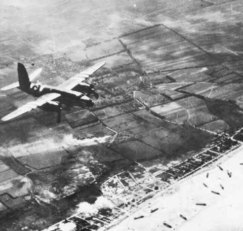
Air power served multiple purposes during the Normandy Invasion. Firstly, it played a pivotal role in clearing the skies of enemy aircraft, ensuring unimpeded aerial access for the Allied forces. The Luftwaffe, Germany's air force, posed a significant threat, and neutralizing it was crucial to protect the landing troops and secure the invasion's objectives.
Secondly, air operations targeted infrastructure, such as railways, bridges, and road networks, to disrupt German reinforcements and hinder the enemy's ability to counter the invasion effectively. Strategic bombing and interdiction missions aimed at weakening the German defenses and isolating their forces in Normandy.
Lastly, air power provided close air support to ground troops during the assault. Aircraft, including fighters, bombers, and attack aircraft, were deployed to provide reconnaissance, suppress enemy fire, and engage in direct attacks on enemy positions. The coordination between air and ground forces allowed for effective battlefield communication and maximized the Allies' chances of success.
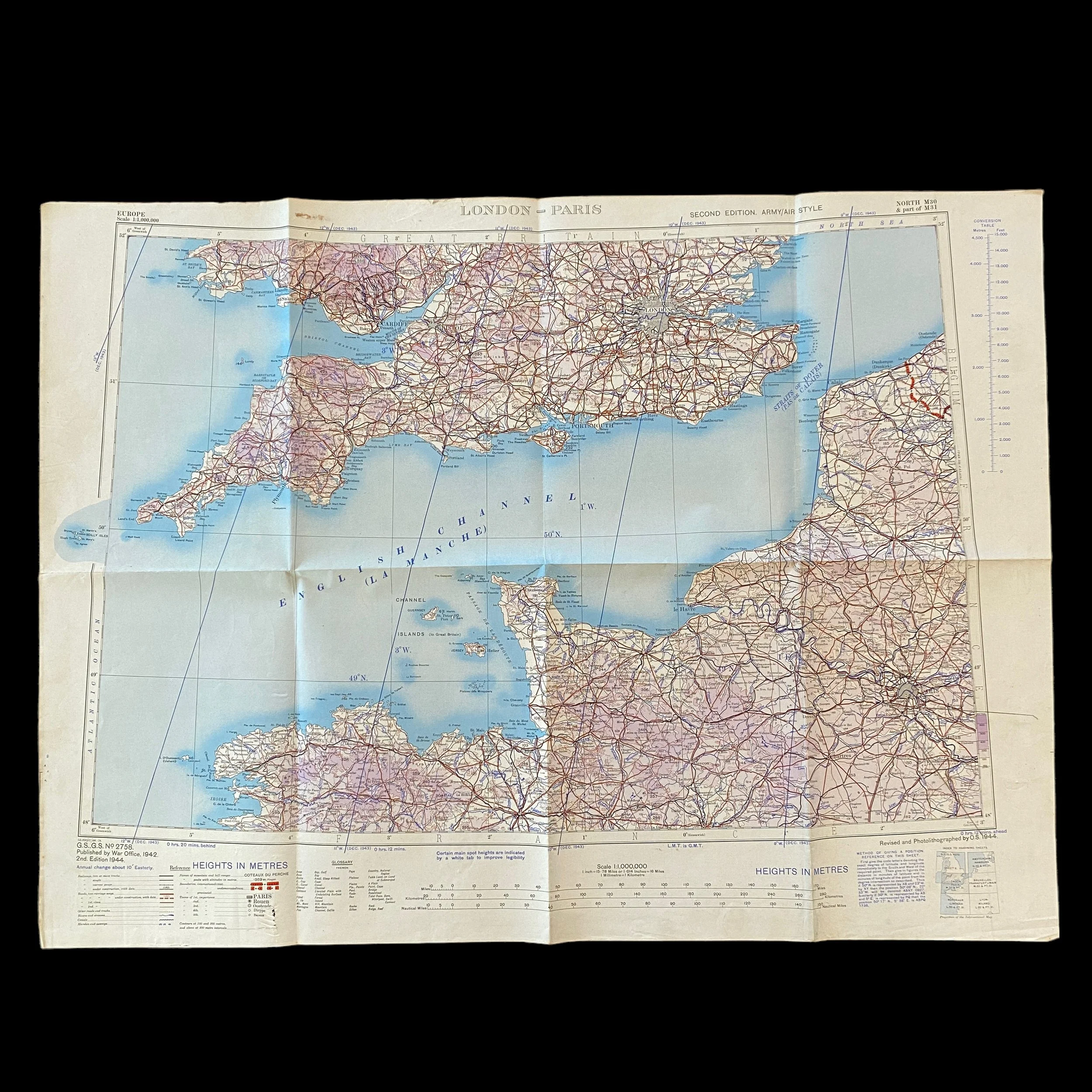
During the Normandy Invasion, the "London - Paris" map served as an invaluable resource for pilots participating in the air campaign. This rare Second Edition Army/Air map, dated 1944, provided detailed information on the region between London and Paris, encompassing the areas crucial to the success of Operation Overlord.
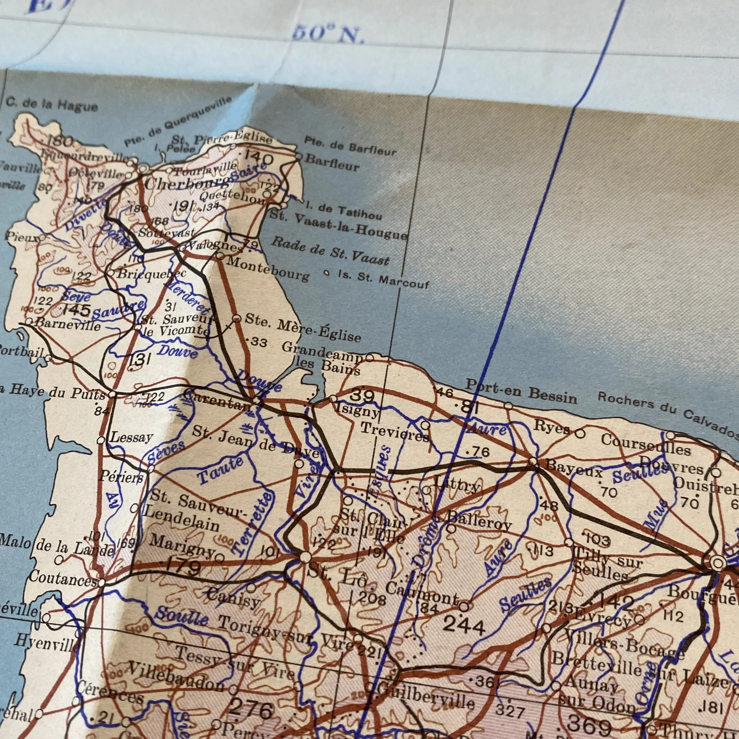
The map likely included various features, such as topographical details, airfields, enemy defenses, target locations, and navigational aids. It would have been used by pilots to plan their routes, identify key targets, and coordinate their operations effectively. The map's accuracy and up-to-date information would have been vital for successful mission execution, enabling pilots to make informed decisions and adapt to changing circumstances.
Furthermore, the "London - Paris" map would have facilitated strategic decision-making at higher levels of command. Air commanders and planners could analyze the map to devise effective air strategies, determine optimal routes, and identify areas for airfield construction and resupply.
The "London - Paris" map would have played a crucial role during the Normandy Invasion by aiding pilots in several ways. Firstly, it would have assisted in mission planning by providing essential information on enemy defenses, such as anti-aircraft installations and radar sites. This knowledge allowed pilots to develop strategies to avoid or neutralize these threats effectively.
Moreover, the map would have highlighted key targets, including German airfields, transportation hubs, and logistical centers. Pilots could use this information to prioritize their attacks and disrupt German operations, hampering their ability to counter the invasion. The map's inclusion of navigational aids would have also helped pilots in accurately locating and reaching their targets.
Additionally, the "London - Paris" map would have been a valuable tool for pilots engaged in close air support missions. It would have allowed them to identify friendly ground units, avoid fratricide incidents, and effectively coordinate with ground forces in real-time.
The Normandy Invasion stands as a testament to the strategic importance of air operations during World War II. The "London - Paris" map, a rare Second Edition Army/Air map from 1944, played a significant role in aiding pilots during this critical phase of the war. By providing vital information on topography, enemy defenses, target locations, and navigational aids, the map facilitated effective mission planning and execution. It empowered pilots to navigate the challenging airspace, neutralize enemy threats, and support the ground forces in their assault.
As a symbol of the indispensable role of air power in the Normandy Invasion, the "London - Paris" map serves as a reminder of the sacrifices made and the strategic brilliance displayed by the Allied forces. By utilizing air superiority and capitalizing on the advantages offered by such invaluable resources, the Allies were able to secure a foothold in Normandy, paving the way for the liberation of Europe and the eventual defeat of Nazi Germany.