RARE! WWII 1944 RESTRICTED "Strait of Dover" Operation Overlord D-Day Invasion Pilot/Navigators Normandy France Mission Air Map


RARE! WWII 1944 RESTRICTED "Strait of Dover" Operation Overlord D-Day Invasion Pilot/Navigators Normandy France Mission Air Map
Comes with C.O.A.
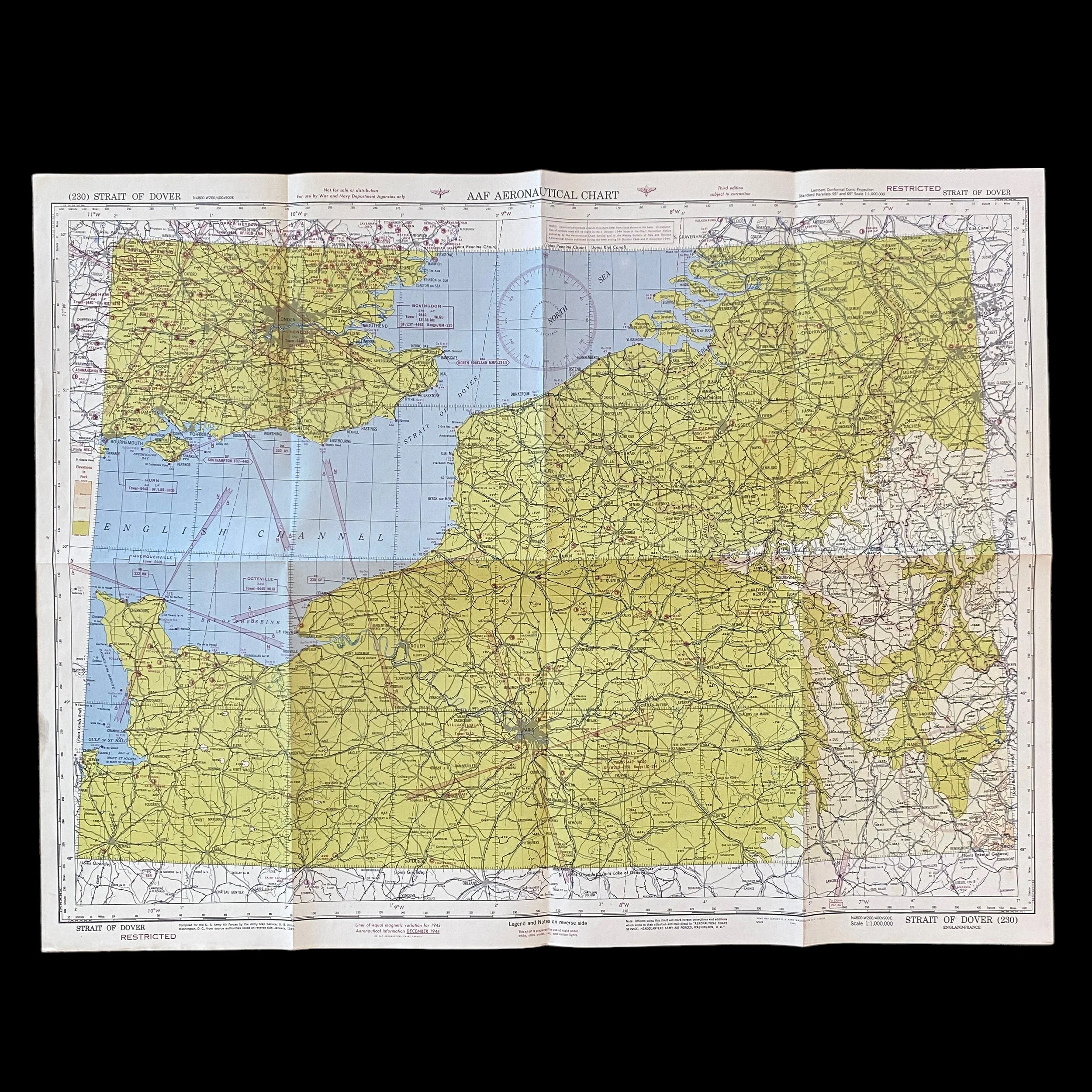
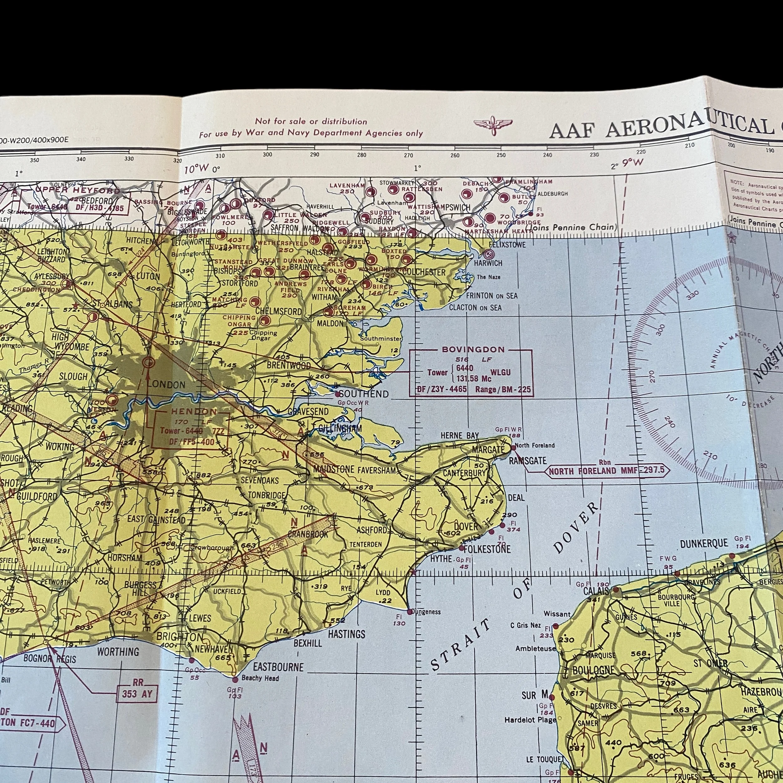
During World War II, the successful execution of the Normandy Invasion, codenamed Operation Overlord, was a pivotal moment that ultimately led to the liberation of Western Europe from Nazi occupation. The invasion required a comprehensive strategy, with air operations playing a vital role in ensuring the success of the mission. Among the crucial tools employed by the Allied forces were specialized maps, including the rare Third Edition "RESTRICTED" marked map titled "Strait of Dover" dated 1944. This essay aims to explore the significance of this unique map in facilitating air operations during the Normandy Invasion and its invaluable contributions to the success of the mission.
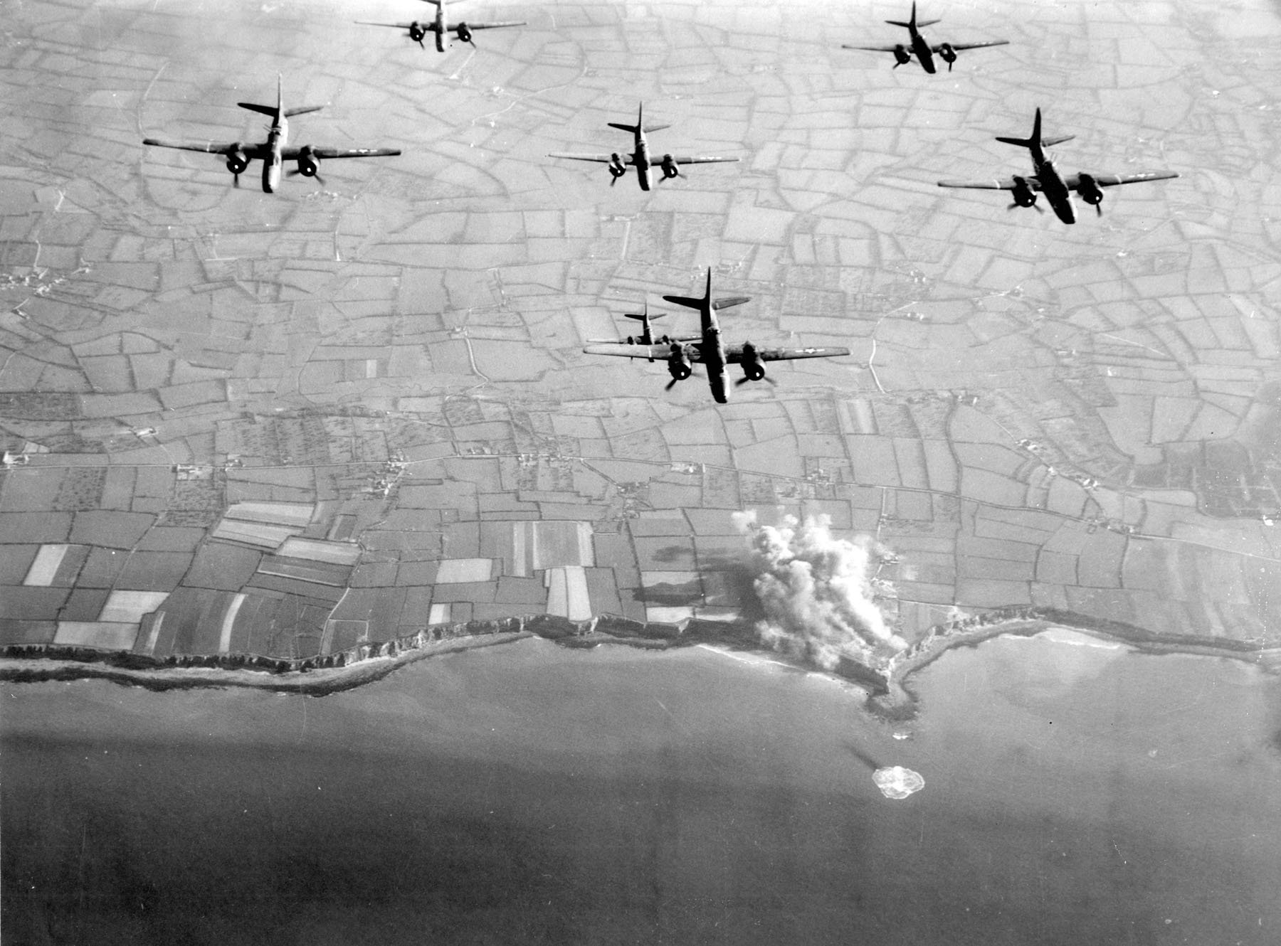
Air superiority was an essential prerequisite for the success of the Normandy Invasion. The Allied forces recognized that control over the skies would allow them to weaken the German defenses, disrupt their lines of communication, and provide crucial support to the ground troops. Air operations were instrumental in achieving these objectives through strategic bombing, interdiction of enemy supply routes, aerial reconnaissance, and close air support.
Maps have always been a fundamental tool for military operations, allowing commanders and troops to navigate, plan, and execute their strategies effectively. During World War II, maps played an indispensable role in guiding aerial missions. They provided pilots with vital information about the terrain, enemy positions, target locations, and friendly forces, enabling them to make informed decisions in real-time.
The Third Edition "RESTRICTED" marked map titled "Strait of Dover," dated 1944, holds immense historical value due to its association with the Normandy Invasion. This map, restricted to authorized personnel only, was carefully prepared and updated to reflect the latest intelligence and operational requirements. Its restricted status ensured that sensitive information was not divulged to the enemy, highlighting the critical nature of the intelligence contained within.
The "Strait of Dover" map was of particular importance for air operations during the Normandy Invasion due to its location and detailed information. The Strait of Dover, separating England and France, served as a strategic chokepoint and a primary route for enemy reinforcements and supplies. The map provided pilots with essential knowledge about this area, including navigational aids, coastal defenses, enemy radar installations, anti-aircraft artillery positions, and minefields. This information was vital for planning and executing effective aerial missions, ensuring that the Allies could establish and maintain air superiority over the English Channel.
Pilots relied on the "Strait of Dover" map to determine optimal flight paths, identify potential threats, and avoid enemy defenses. They used the map to plot courses that minimized exposure to enemy radar and anti-aircraft fire, while also identifying targets for strategic bombing and interdiction operations. The map's accurate depiction of the terrain, including natural landmarks, coastal features, and known enemy strongholds, facilitated precise navigation and target identification.
Furthermore, the "Strait of Dover" map served as a valuable intelligence resource, allowing pilots to stay up-to-date with real-time information. As the Allies constantly gathered intelligence on enemy movements and defenses, the map was continuously updated with new data. Pilots could refer to this information before and during their missions, enabling them to adapt their strategies and tactics to the evolving battlefield conditions.
The rare Third Edition "RESTRICTED" marked map titled "Strait of Dover" dated 1944 played a vital role in supporting air operations during the Normandy Invasion. Its detailed information, restricted status, and continuous updates made it an indispensable tool for pilots, helping them navigate through the Strait of Dover, identify enemy positions, and plan and execute their missions effectively. This map symbolizes the importance of accurate intelligence, strategic planning, and the seamless integration of air power in achieving victory in one of the most significant military campaigns in history. The contributions of air operations, facilitated by maps like the "Strait of Dover," were instrumental in the success of the Normandy Invasion, leading to the liberation of Western Europe and ultimately the end of World War II.