VERY RARE! WWII 1944 D-Day Operation Overlord "RESTRICTED" After-Action Combat Intelligence Report Map - U.S. Airborne & Glider Operations


VERY RARE! WWII 1944 D-Day Operation Overlord "RESTRICTED" After-Action Combat Intelligence Report Map - U.S. Airborne & Glider Operations
Comes with a hand-signed C.O.A. and a multi-page historical researched write-up:
*In total, only 420 copies of this “CONFIDENTIAL” after-action map were created. This is the same original after-action D-Day map that was distributed to Generals Eisenhower, Marshall, Bradley, Ridgeway, Gavin, March, Eaton and other high-ranking officers. SEE LISTING PHOTOS FOR A DIGITAL COPY OF THE SECRET DISTRIBUTION LIST/COUNT.
This EXTREMELY RARE and museum-grade 1944 dated WWII Operation Overlord D-Day artifacts is one of a handful of original D-Day after-action combat report maps to exist detailing the U.S. AIRBORNE and GLIDER assault on D-Day June 6th, 1944. In total, only 420 copies of this “CONFIDENTIAL” after-action map were created.
Under General Eisenhower’s direction, 420 copies of these historical narrative reports were created using the exact “RESTRICTED” D-Day and D-Day + after-action combat reports of the 508th Parachute Infantry Regiment, 325th Glider Infantry Regiment, 82nd Airborne Division, 80th Airborne Antiaircraft Battalion, 307th Airborne Engineer Battalion, 307th Medical Company, and 82nd Airborne Signal Company.
Distributed a few weeks following the Operation Overlord D-Day assault of Normandy and were meant to visually detail the after-action reports of the U.S. Airborne operation in Normandy, France to high-command generals and officers. This was the second most SECRET document set that was produced by the Allies following the secrecy of the “TOP SECRET” BIGOT map distribution.
This very rare U.S. Airborne D-Day after-action combat report map was produced by the 669th Engineer Topographic Company and was created for high-command generals, officers, and Division HQs. What makes this map even more sought after is that there is a very detailed historical account of the exact distribution of each map.
This is the same original after-action D-Day map that was distributed to Generals Eisenhower, Marshall, Bradley, Ridgeway, Gavin, March, Eaton and other high-ranking officers.
Titled “PARACHUTE TAKE OFF FIELDS & GLIDER TAKE OFF FIELDS” this after-action map illustrates the SECRET Operation Overlord take off fields of the U.S. Airborne and Glider units for the D-Day invasion of Normandy.
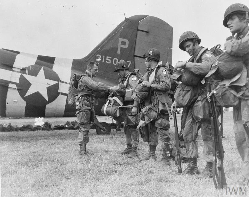
American airborne landings in Normandy were a series of military operations carried by the United States as part of Operation Overlord, the invasion of Normandy by the Allies on June 6, 1944 during World War II. Approximately 13,100 American paratroopers from the 82nd and 101st Airborne Divisions conducted parachute drops, followed by 3,937 glider infantrymen, on June 6.[2] As the opening maneuver of the Normandy landings, the two American airborne divisions were dropped in Normandy via two parachute and six glider missions.
On April 12 a route was approved that would depart England at Portland Bill, fly at low altitude southwest over water, then turn 90 degrees to the southeast and come in "by the back door" over the western coast. At the initial point the 82nd Airborne Division would continue straight to La Haye-du-Puits, and the 101st Airborne Division would make a small left turn and fly to Utah Beach. The plan called for a right turn after drops and a return on the reciprocal route.
Airborne Assault into Normandy:
The airborne assault into Normandy, as part of the D-Day allied invasion of Europe, was the largest use of airborne troops up to that time. Paratroopers of the U.S. 82nd and 101st Airborne Divisions, the British 6th Airborne Division, the 1st Canadian Parachute Battalion, and other attached Allied units took part in the assault. Numbering more than 13,000 men, the paratroopers were flown from bases in southern England to the Cotentin Peninsula in approximately 925 C-47 airplanes. An additional 4,000 men, consisting of glider infantry with supporting weapons, medical, and signal units were to arrive in 500 gliders later on D-Day to reinforce the paratroopers. The parachute troops were assigned what was probably the most difficult task of the initial operation - a night jump behind enemy lines five hours before the coastal landings.
To protect the invasion zone's western extremity and to facilitate the "Utah" landing force's movement into the Cotentin Peninsula, the U.S. 82nd and 101st Airborne Divisions descended on the peninsula by parachute and glider in the early hours of D-Day. The paratroopers were badly scattered. Many were injured and killed during the attack, and much of their equipment was lost, but the brave paratroopers fought fiercely, causing confusion among the German commanders and keeping the German’s troops occupied. Their efforts; hampered by harsh weather, darkness and disorganization, and initiative of resourceful Soldiers and leaders, ensured that the Utah Beach assault objectives were eventually accomplished. The British and Canadian attacks also accomplished their primary goal of securing the left flank of the invasion force.
D-Day Plans and Revisions:
Plans for the invasion of Normandy went through several preliminary phases throughout 1943, during which the Combined Chiefs of Staff (CCS) allocated 13½ U.S. troop carrier groups to an undefined airborne assault. The actual size, objectives, and details of the plan were not drawn up until after General Dwight D. Eisenhower became Supreme Allied Commander in January 1944. In mid-February Eisenhower received word from Headquarters U.S. Army Air Forces that the TO&E of the C-47 Skytrain groups would be increased from 52 to 64 aircraft (plus nine spares) by April 1 to meet his requirements. At the same time the commander of the U.S. First Army, Lieutenant General Omar Bradley, won approval of a plan to land two airborne divisions on the Cotentin Peninsula, one to seize the beach causeways and block the eastern half at Carentan from German reinforcements, the other to block the western corridor at La Haye-du-Puits in a second lift. The exposed and perilous nature of the La Haye de Puits mission was assigned to the veteran 82nd Airborne Division ("The All-Americans"), commanded by Major General Matthew Ridgway, while the causeway mission was given to the untested 101st Airborne Division ("The Screaming Eagles"), which received a new commander in March, Brigadier General Maxwell D. Taylor, formerly the commander of the 82nd Airborne Division Artillery who had also been temporary assistant division commander (ADC) of the 82nd Airborne Division, replacing Major General William C. Lee, who suffered a heart attack and returned to the United States.
Bradley insisted that 75 percent of the airborne assault be delivered by gliders for concentration of forces. Because it would be unsupported by naval and corps artillery, Ridgway, commanding the 82nd Airborne Division, also wanted a glider assault to deliver his organic artillery. The use of gliders was planned until April 18, when tests under realistic conditions resulted in excessive accidents and destruction of many gliders. On April 28 the plan was changed; the entire assault force would be inserted by parachute drop at night in one lift, with gliders providing reinforcement during the day.
The Germans, who had neglected to fortify Normandy, began constructing defenses and obstacles against airborne assault in the Cotentin, including specifically the planned drop zones of the 82nd Airborne Division. At first no change in plans were made, but when significant German forces were moved into the Cotentin in mid-May, the drop zones of the 82nd Airborne Division were relocated, even though detailed plans had already been formulated and training had proceeded based on them.
Just ten days before D-Day, a compromise was reached. Because of the heavier German presence, Bradley, the First Army commander, wanted the 82nd Airborne Division landed close to the 101st Airborne Division for mutual support if needed. Major General J. Lawton Collins, commanding the VII Corps, however, wanted the drops made west of the Merderet to seize a bridgehead. On May 27 the drop zones were relocated 10 miles (16 km) east of Le Haye-du-Puits along both sides of the Merderet. The 101st Airborne Division's 501st Parachute Infantry Regiment (PIR), which had originally been given the task of capturing Sainte-Mère-Église, was shifted to protect the Carentan flank, and the capture of Sainte-Mère-Église was assigned to the veteran 505th PIR of the 82nd Airborne Division.
For the troop carriers, experiences in the Allied invasion of Sicily the previous year had dictated a route that avoided Allied naval forces and German anti-aircraft defenses along the eastern shore of the Cotentin. On April 12 a route was approved that would depart England at Portland Bill, fly at low altitude southwest over water, then turn 90 degrees to the southeast and come in "by the back door" over the western coast. At the initial point the 82nd Airborne Division would continue straight to La Haye-du-Puits, and the 101st Airborne Division would make a small left turn and fly to Utah Beach. The plan called for a right turn after drops and a return on the reciprocal route.
However the change in drop zones on May 27 and the increased size of German defenses made the risk to the planes from ground fire much greater, and the routes were modified so that the 101st Airborne Division would fly a more southerly ingress route along the Douve River (which would also provide a better visual landmark at night for the inexperienced troop carrier pilots). Over the reluctance of the naval commanders, exit routes from the drop zones were changed to fly over Utah Beach, then northward in a 10 miles (16 km) wide "safety corridor", then northwest above Cherbourg. As late as May 31 routes for the glider missions were changed to avoid overflying the peninsula in daylight.
D-Day Mission:
The assault lift (one air transport operation) was divided into two missions, "Albany" and "Boston", each with three regiment-sized landings on a drop zone. The drop zones of the 101st were northeast of Carentan and lettered A, C, and D from north to south (Drop Zone B had been that of the 501st PIR before the changes of May 27). Those of the 82nd were west (T and O, from west to east) and southwest (Drop Zone N) of Sainte-Mère-Eglise.
Each parachute infantry regiment (PIR), a unit of approximately 1800 men organized into three battalions, was transported by three or four serials, formations containing 36, 45, or 54 C-47s, and separated from each other by specific time intervals. The planes, sequentially designated within a serial by chalk numbers (literally numbers chalked on the airplanes to aid paratroopers in boarding the correct airplane), were organized into flights of nine aircraft, in a formation pattern called "vee of vee's" (vee-shaped elements of three planes arranged in a larger vee of three elements), with the flights flying one behind the other. The serials were scheduled over the drop zones at six-minute intervals. The paratroopers were divided into sticks, a plane load of troops numbering 15-18 men.
To achieve surprise, the parachute drops were routed to approach Normandy at low altitude from the west. The serials took off beginning at 22:30 on June 5, assembled into formations at wing and command assembly points, and flew south to the departure point, code-named "Flatbush". There they descended and flew southwest over the English Channel at 500 feet (150 m) MSL to remain below German radar coverage. Each flight within a serial was 1,000 feet (300 m) behind the flight ahead. The flights encountered winds that pushed them five minutes ahead of schedule, but the effect was uniform over the entire invasion force and had negligible effect on the timetables. Once over water, all lights except formation lights were turned off, and these were reduced to their lowest practical intensity.
Twenty-four minutes 57 miles (92 km) out over the channel, the troop carrier stream reached a stationary marker boat code-named "Hoboken" and carrying a Eureka beacon, where they made a sharp left turn to the southeast and flew between the Channel Islands of Guernsey and Alderney. Weather over the channel was clear; all serials flew their routes precisely and in tight formation as they approached their initial points on the Cotentin coast, where they turned for their respective drop zones. The initial point for the 101st at Portbail, code-named "Muleshoe", was approximately 10 miles (16 km) south of that of the 82d, "Peoria", near Flamanville.