WWII D-Day Operation Neptune Planning (“CHERBOURG - COTENTIN SECTOR” ) Amphibious Landing Craft Navigational Fathom Chart


WWII D-Day Operation Neptune Planning (“CHERBOURG - COTENTIN SECTOR” ) Amphibious Landing Craft Navigational Fathom Chart
Comes with hand-signed C.O.A.
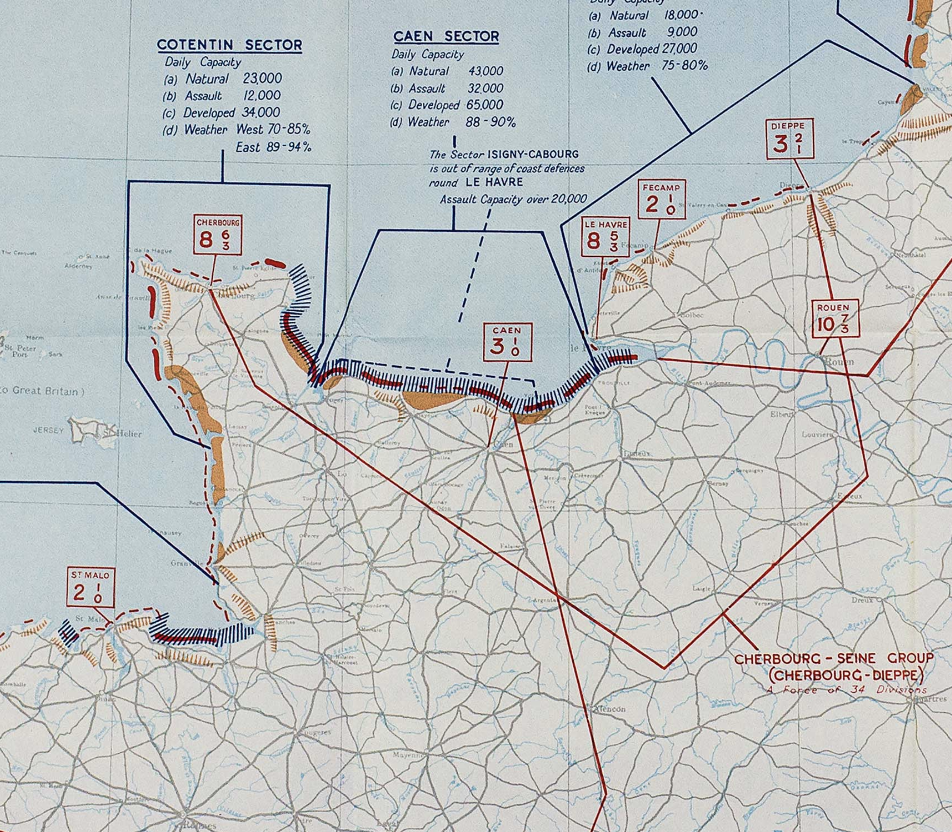
This original, exceptionally rare and museum-grade WWII amphibious fathom chart (dated April 15th, 1943) was created as a part of the SECRET Allied Operation Neptune and the June 6th, 1944 D-Day Invasion of Normandy. This Operation Neptune planning chart was BIGOT labelled as the “COTENTIN SECTOR” and was being considered as possible landing beaches for the D-Day landings as of 1943 and early 1944.
The planning for Operation Neptune began in 1943 when Allied leaders began discussing the possibility of a large-scale invasion of Europe. The planning involved a wide range of military, political, and logistical considerations, including the selection of a suitable location for the invasion. Several potential landing sites were considered, including Pas-de-Calais, Brittany, and Normandy. Pas-de-Calais was the closest point to England and was heavily fortified by the Germans, making it a risky choice for the invasion. Brittany was another potential location, but it was farther from England and lacked suitable ports for the large-scale landing of troops and supplies. Ultimately, Normandy was selected as the location for the invasion due to its relative proximity to England and its suitability for a large-scale amphibious landing. Once Normandy was selected, the planning process intensified. The invasion required a massive buildup of troops, equipment, and supplies, which had to be coordinated and transported across the English Channel. The logistics of the operation were complex and required the construction of temporary harbors, known as Mulberries, to enable the rapid offloading of troops and supplies.
The planning for the invasion also involved extensive reconnaissance of the Normandy coastline. Allied intelligence officers gathered information on the German defenses, including the locations of bunkers, artillery positions, and minefields. This information was used to develop detailed invasion plans, which included the selection of landing sites, the timing of the attack, and the deployment of troops. In addition to military planning, Operation Neptune also involved extensive political coordination. The invasion required the cooperation of multiple Allied nations, including the United States, Great Britain, Canada, and others. This coordination involved the allocation of troops and resources, as well as the establishment of a unified command structure.
As the date of the invasion approached, the preparation intensified. The troops were trained and equipped, and final preparations were made for the landing. The weather was a significant factor in the planning, and the invasion was delayed several times due to adverse weather conditions. Despite the challenges and risks involved, the planning and preparation paid off, and the Allied forces were successful in their invasion of Normandy. The invasion marked a turning point in the war, and it helped to pave the way for the eventual defeat of Germany.
The planning and preparation that went into Operation Neptune were extensive and complex. The selection of Normandy as the location for the invasion was the result of careful consideration of a range of factors, including geography, military strategy, and logistical considerations. The success of the invasion was due in large part to the meticulous planning and preparation that went into it, as well as the bravery and dedication of the Allied troops who carried it out.
This fathom map was created to be used in this area of France for the possible D-Day landing beaches. It would have been used for the direct navigation onto the beachheads by the LCVP (Landing Craft Vehicle & Personal Higgins), LCI (Landing Craft Infantry), LCM (Landing Craft Medium), and LST (Landing Ship Tank).
This double-sided amphibious beachhead chart vividly illustrates the intensive planning and operational accuracy that was behind Operation Neptune, the largest amphibious seaborne invasion in history. This particular amphibious chart were created under the direction of Vice-Admiral Sir John Edgell. Edgell oversaw all of the mapping projects related to World War II, and paid special attention to the TOP SECRET maps/charts his office prepared for Operation Neptune and Overlord (the larger Allied mission to re-take France).
Their smaller size was intentionally done as they were carried in a waterproof booklet and used a reference guides on the battlefields/landing areas as it even has an area for a compass to be placed for even more accurate navigation to the beach.