RARE WWII 11th Airborne Task Force Gypsy Appari C-47 C-46 CG-13 Glider Air Support Chart Map No. 1

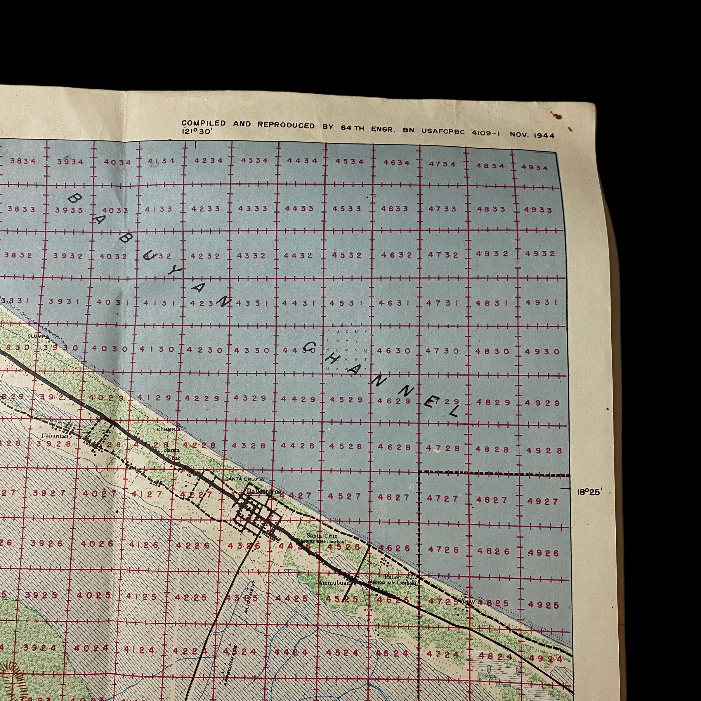


RARE WWII 11th Airborne Task Force Gypsy Appari C-47 C-46 CG-13 Glider Air Support Chart Map No. 1
Size: 15 x 24 inches
Compiled from A.M.S. (Army Map Services) Series S712 - Sept. 1944 this extremely rare WWII map was used in support of the last American combat air assault operation of WWII. Titled “Air Support Chart No. 1 Appari ” this CONFIDENTIAL marked 1944 dated Pacific Theater air navigational and altitude map was compiled and reproduced by the 64th Engineer Topographic Battalion USAFCPBC. This is one of very few that exist today from the rare ‘Air Support Appari’ series used during the bitter fighting for Northern Luzon, Philippines in the final months of World War II. It was here where the 37th Infantry Division (Ohio National Guard) was tasked flanking the main Japanese positions and seizing the coastal town of Aparri. This was the scene of one of the first Japanese amphibious landings in the 1941-42 campaign. General Walter Krueger decided to commit elements of the 11th Airborne Division to the attack, which he hoped would ultimately surround one of the last major Japanese army formations on the island (Shobu Group with about 50,000 men).
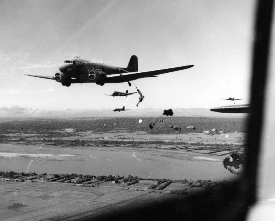
The operation began on June 21, 1945 when a small group of Pathfinders air assaulted onto Camalaniugan Airfield to prep the LZ. Two days later, on the morning of June 23rd, the men of Task Force Gypsy climbed into sixty-seven C-47’s and C-46 transports for the short flight to the LZ. As the aircraft arrived overhead, the Pathfinders on the group popped colored smoke to mark the drop zones. Heavy winds hampered the parachutists. Two were killed and at least another seventy suffered injuries as they were buffeted by the winds and thrown into trees or other terrain features on the ground. The airfield itself was poorly developed and the uneven ground proved treacherous. A half dozen Waco CG-4 gliders landed after the parachutists got on the ground. They carried the task force’s heavy weapons and jeeps, giving Gypsy a bit of mobility.
The task force quickly assembled and began patrolling south of the airfield, where the paratroops ran into determined resistance. For three days, the men of the 511th and 457th Parachute Field Artillery Bn (attacked to TF Gypsy), burned out bunkers with flame throwers, destroyed pillboxes with 75mm pack howitzer fire and waited for the 37th to reach them. It took until June 26th for the two American elements to link up, but when they did, the Shobu Group’s escape route to the coast had been cut off. The Japanese troops faced a grim fate: starvation, death or surrender.
The Aparri operation was the last American combat air assault operation of WWII. A number of combat cameramen joined the mission, taking extensive film and photographs while in the LZ. Below is one reel of uncut, unedited footage shot by one of those men on June 23, 1945.
The 11th Airborne Campaign On Aparri:
Northern Luzon is bounded on the north and east by the Pacific Ocean and on the west by Lingayen Gulf and the South China Sea. The Cagayan Valley, averaging 40 miles in width, stretches from Aparri on the north coast to Bambang in the south, a distance of 200 miles. This fertile valley, resting between the Cordillera Mountain Range on the west and the Sierra Madre Range on the east coast, provided much of the food for northern Luzon. Except for the beaches at Aparri, only tortuous trails over narrow mountain passes allowed access into the boxed valley in 1945. This was the natural stronghold selected by General Yamashita and his Shobo Group of 152,000 men, determined to defend Northern Luzon by concentrating his Japanese detachments at various approaches to the Cagayan Valley with his headquarters at Baguio, 20 miles northeast of Rosario.
In June 1945, the 37th Division was attacking up the Cagayan Valley, to block the Japanese escape by sea, General Swing (the CG of the 11th Airborne Division) formed Task Force Gypsy. It was composed of the 1st Battalion of the 511th PIR, as the major element with "G" and "I" companies, from the 3rd Bn. attached. Supporting units attached were, Battery "C" of the 457th, a platoon from the 127th Airborne Engineer Bn., and teams from the 221st Medics, 511th Signal Company, the Language Detachment, the CIC, and the 11th Parachute Maintenance Company. Colonel Henry Burgess, the XO of the 511th PIR was placed in command.
Lipa Airstrip, built by the Japanese in 1943 was selected as the staging area. It had a concrete runaway, and it made its name when it was used by the Japanese in December 1944 when they made a parachute assault on the 11th Airborne on the San Pablo airstrips on Leyte. For the assault, the 317th Troop Carrier Group, under the command of Colonel John Lackey assembled 54 C-47s, 13 C-46s, seven CG-4A and one CG-13 gliders at Lipa Airstrip. This was the first and only use of gliders in the Pacific Theatre, in WWII. On June 21, 1945 the Pathfinders from the 11th contacted Colonel Volckmann and his guerrillas. On the night before the drop, they slipped across the Cagayan River and prepared to mark the drop zone at Camalaniugan.
The Task Force began loading at 0430 on the 23 of June for a 0600 take off. As the force was heading toward Aparri, it was shielded by the mountains to the south and by smoke laid down by supporting fighter aircraft. The pathfinders popped the green smoke for Burgess's Task Force at 0900. The winds over the drop zone area were 20 to 25 knots, and the terrain on the drop zone was flooded with rice paddies, caribou wallows, bomb craters and tall kunai grass. Jump casualties were high (two men killed and 70 injured), a rate of about seven percent. Burgess assembled his men and started the march south against relatively little enemy opposition.
On June 26, Task Force gypsy's point men ran into the lead elements of the 37th Division near the Paret River, about 35 miles south of the Camalaniugan drop zone.
*PLEASE NOTE THE BLACK AND WHITE PHOTOS ARE DIGITAL HISTORICAL REFERENCE PHOTOS.