RARE! WWII Allied Bombing Campaign Bremen Germany Navigators HEAVILY MARKED Mission Map


RARE! WWII Allied Bombing Campaign Bremen Germany Navigators HEAVILY MARKED Mission Map
Comes with C.O.A.
*In just over five years, the Allies carried out a total of 173 air raids on Bremen, dropping 5,513 tons of explosive devices, and killing more than 4,000 residents. In addition to the city center, almost 65,000 houses and apartments were destroyed, corresponding to around 62 percent of the city's residential accommodation. The west of Bremen with the districts of Walle and Gröpelingen was particularly hard hit.
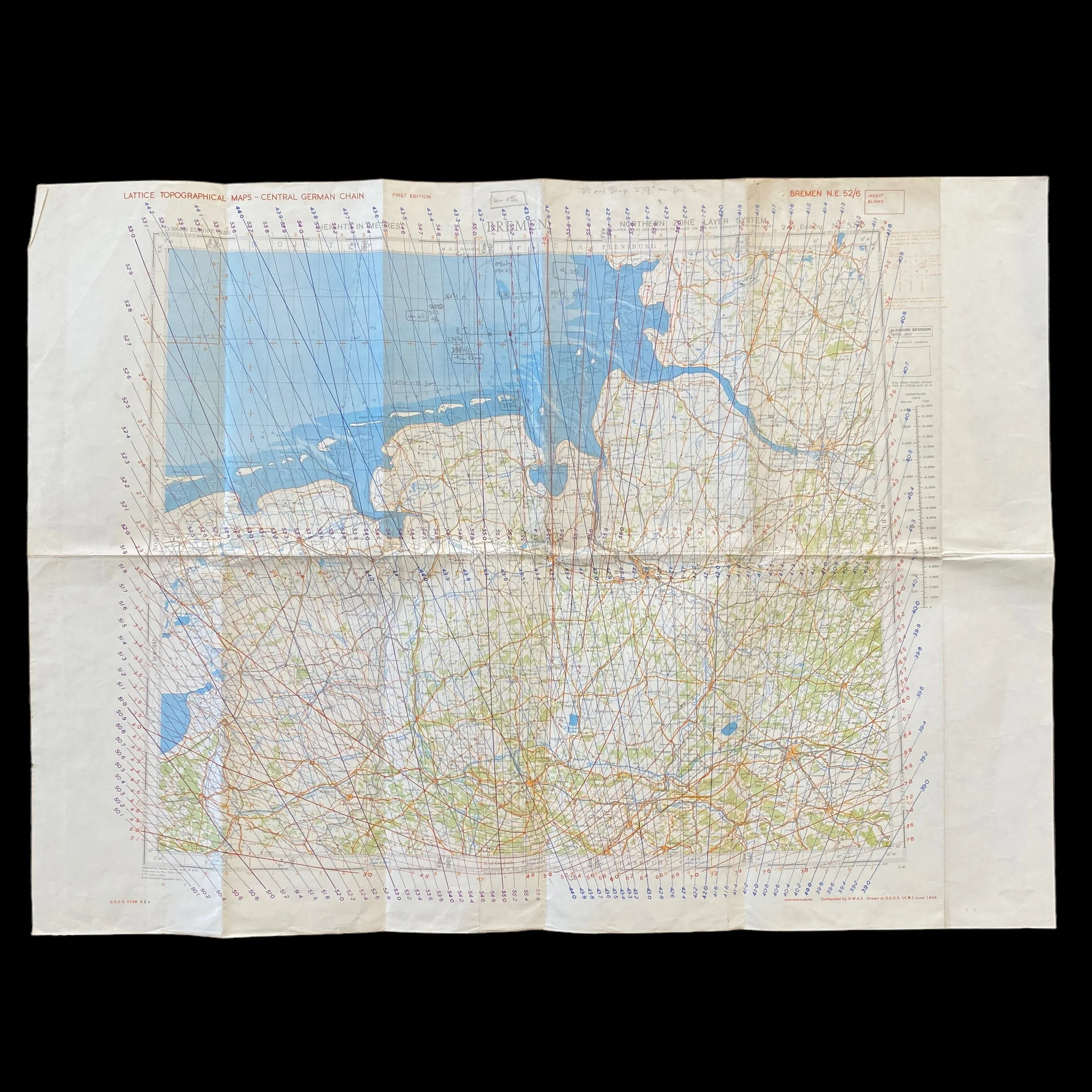
This incredibly rare and museum-grade World War II “LATTICE - TOPOGRAPHICAL MAP “ titled Bremen is a Allied navigators heavily missions marked from Allied bombing raids on Bremen, Germany during World War II.
The Bombing of Bremen in World War II by the British Royal Air Force (RAF) and US Eighth Air Force involved both indiscriminate "area bombing" and, as capacity improved, more targeted raids upon the city's military-industrial facilities. These included the shipyards of Vulkan, AG Weser and Atlas Werke, the Valentin submarine pens, oil refineries and the aircraft works of Focke-Wulf. Early RAF raids on Bremen beginning in May 1940 had sought out these industrial and military targets but the efforts proved costly and, given limited navigation and target-location capabilities, impractical. From September 1941 the RAF switched to night-time "area bombing". In the spring of 1942 new directives from Bomber Command under Air Marshal Arthur Harris formalised the change of strategy. Purporting to draw lessons from the German Blitz on Britain, Bomber Command concluded that rather than being "collateral damage", the destruction of residential districts and the killing of civilians served the legitimate purpose of weakening enemy morale. To demonstrate the effectiveness of area bombing, Bomber Command sought to overwhelm city defences with "1,000 bomber" raids. The first of these mounted against Bremen was on 25 June 1942. Six hundred houses were destroyed but civil defence measures kept civilian casualties to 88. Flak and Luftwaffe fighters were able to shoot down 49 RAF bombers. Subsequent attacks were carried out by fewer but improved aircraft, and as Bremen's air-defence depleted (fighter aircraft were redeployed to the eastern front), these caused significantly more damage. At the beginning of 1943, the daytime targeting of industrial and military facilities returned with the arrival over Bremen of the 8th US Air Force. In the first year, the "Mighty Eighth" suffered considerable losses. The German authorities began to evacuate industrial facilities from the city as a precaution. On 8 October 1943, the British began a new wave of heavy night attacks. The heaviest air raid of the entire war hit the city on the night of August 18–19, 1944. In just 34 minutes 274 aircraft dropped 1,120 tons of bombs over the densely built-up west of the city killing 1,059 people, destroying 8,248 residential buildings, and leaving 50,000 homeless.
The Strategic Significance of WWII Lattice Topographical Maps in Allied Bombing Campaigns over Germany
World War II marked a pivotal moment in the history of warfare, introducing unprecedented technological innovations that reshaped the dynamics of conflict. One such innovation that played a crucial role in Allied bombing campaigns over Germany was the use of lattice topographical maps. These intricate and detailed maps, characterized by their grid-like structure, provided Allied bombing aircraft with essential information for navigation, target identification, and strategic planning.
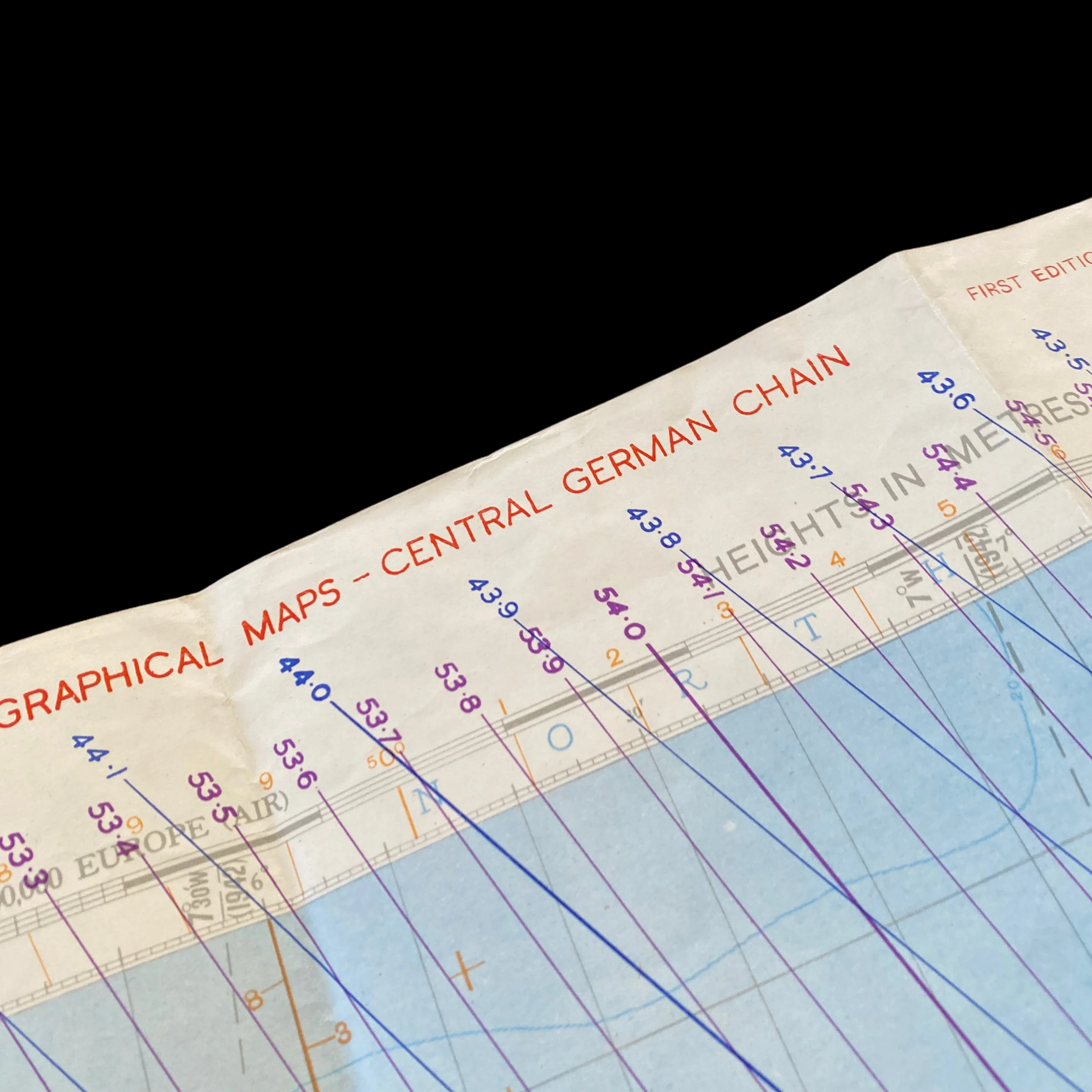
Lattice topographical maps were a product of advanced cartographic techniques that emerged during the early stages of World War II. These maps were characterized by a grid pattern overlaying traditional topographical features, enabling precise location identification and navigation for aircrews. The development of these maps was a collaborative effort between military intelligence, cartographers, and aerial reconnaissance units, seeking to overcome the challenges posed by the complex and rapidly changing terrain of wartime Europe.
The lattice structure allowed for quick and accurate coordination of bombing missions. Each square on the grid corresponded to a specific geographical area, facilitating communication between aircrews and ground control. This innovation was particularly crucial in the context of bombing campaigns over Germany, where the landscape varied significantly, from densely populated urban areas to industrial complexes and military installations.
One of the primary advantages of lattice topographical maps was their contribution to precision bombing. Unlike earlier maps, which lacked the level of detail necessary for accurate target identification, lattice maps provided aircrews with a comprehensive view of the terrain, including key landmarks, infrastructure, and potential military targets. This precision was instrumental in minimizing collateral damage and civilian casualties, a factor that became increasingly important as the war progressed.
The intricate grid system also played a crucial role in target coordination. Ground control and aircrews could communicate with precision, ensuring that each mission was directed toward specific strategic objectives. This level of coordination was essential in disrupting German war production, crippling transportation networks, and eroding the morale of both the military and civilian populations.
The use of lattice topographical maps significantly influenced strategic planning for Allied bombing campaigns over Germany. The detailed information provided by these maps allowed military planners to identify key targets, assess the vulnerability of enemy defenses, and plan routes that optimized the chances of mission success. As a result, the Allies were able to execute more effective and targeted bombing raids, ultimately contributing to the erosion of Germany's industrial and military capabilities.
Moreover, the ability to navigate through the intricate lattice grid allowed Allied aircraft to exploit weaknesses in German air defenses. By selecting routes that avoided heavily fortified areas and anti-aircraft emplacements, Allied aircrews increased their chances of survival and mission success. This strategic advantage, coupled with the precision enabled by lattice topographical maps, played a pivotal role in shaping the outcome of the air war over Germany.
The use of lattice topographical maps during World War II represented a significant leap forward in the field of military cartography and aerial reconnaissance. These maps played a crucial role in enhancing the precision of bombing missions, minimizing collateral damage, and contributing to the overall success of Allied strategic bombing campaigns over Germany. The intricate grid system facilitated efficient communication and coordination between aircrews and ground control, allowing for more effective targeting of key military and industrial installations. As a result, lattice topographical maps stand as a testament to the ingenuity and adaptability of military strategy during one of the most transformative periods in modern history.