VERY RARE! Original 1903 New York City - Laurel Hill - Long Island City Queens Early 1900's NYC Blueprint Map (PLATE 21)*
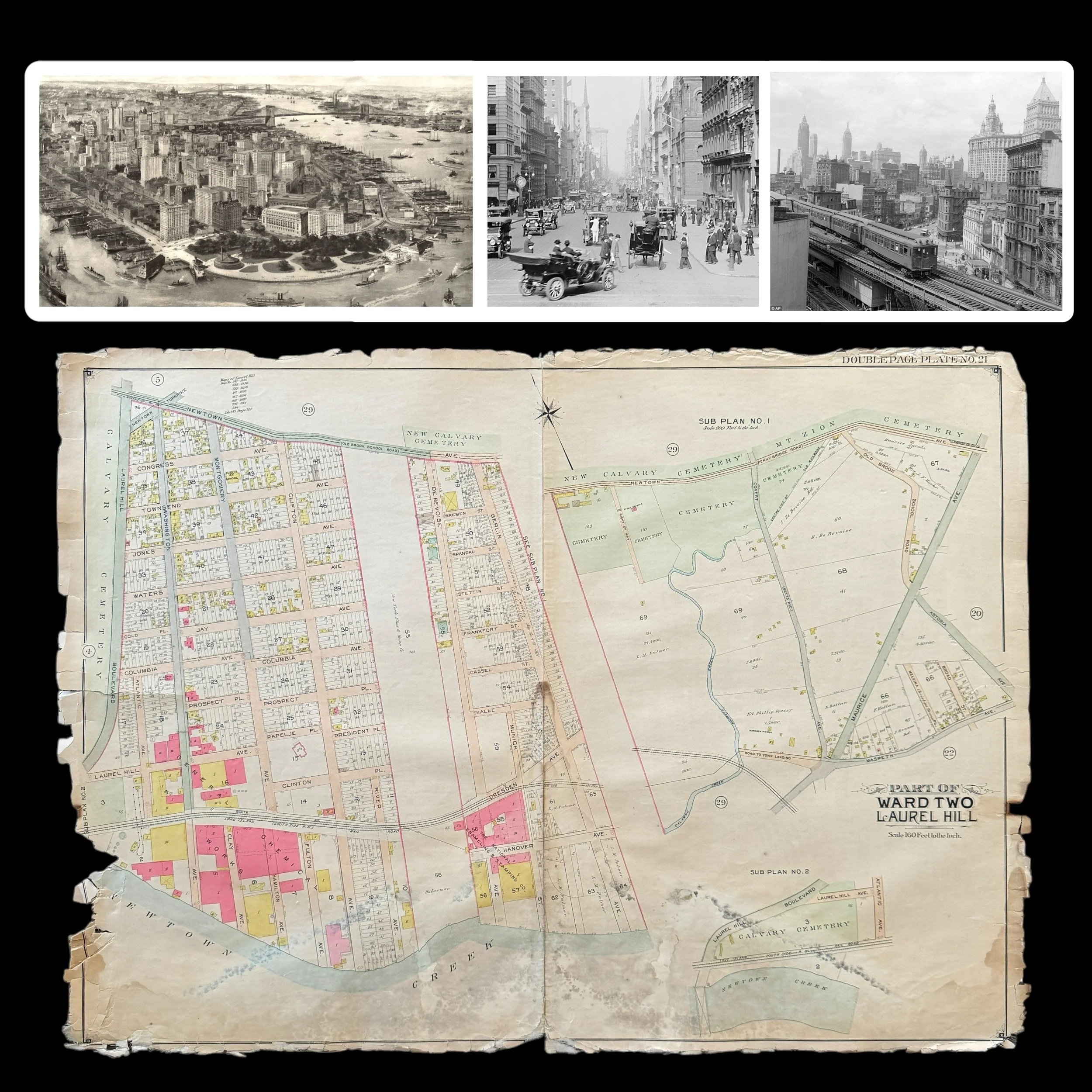
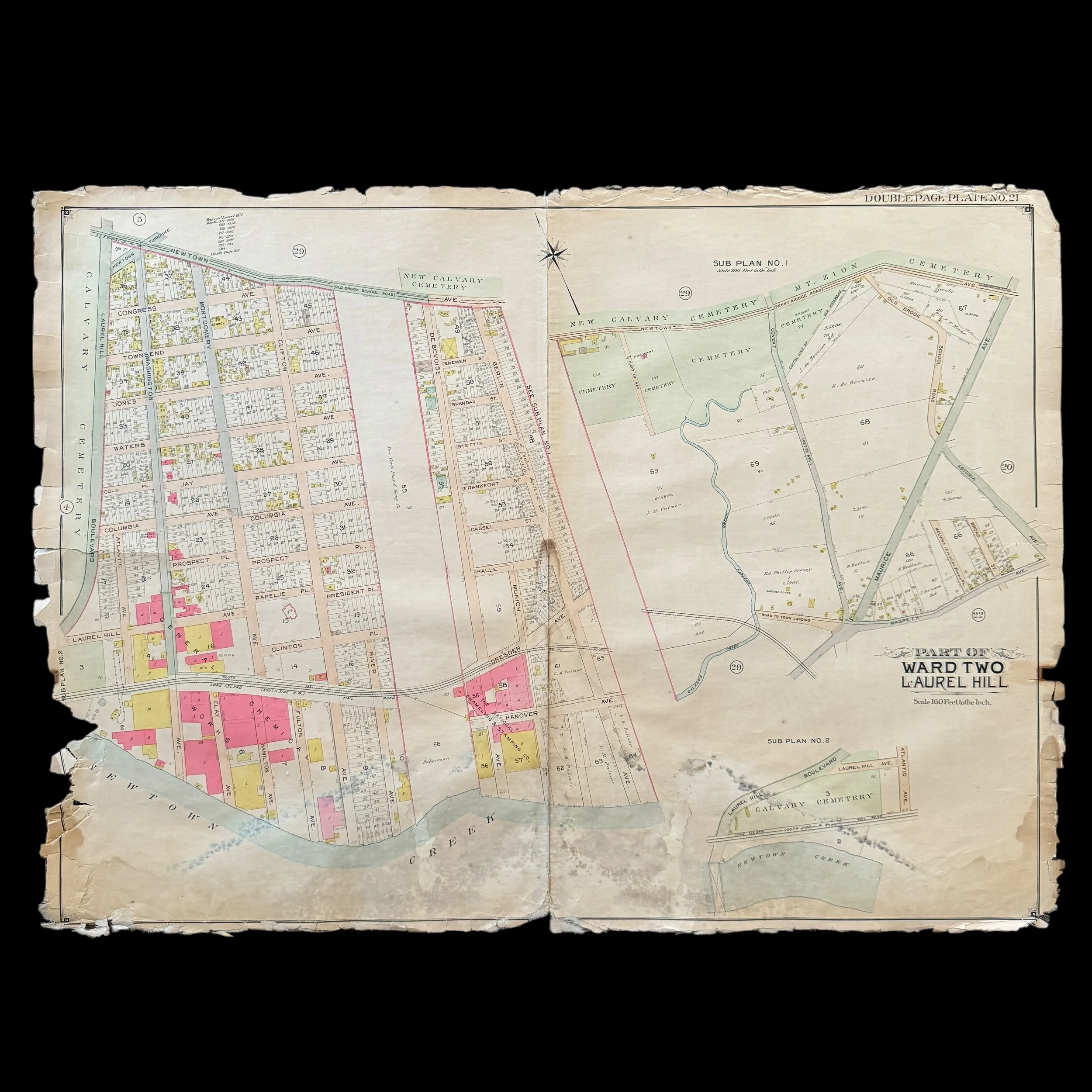
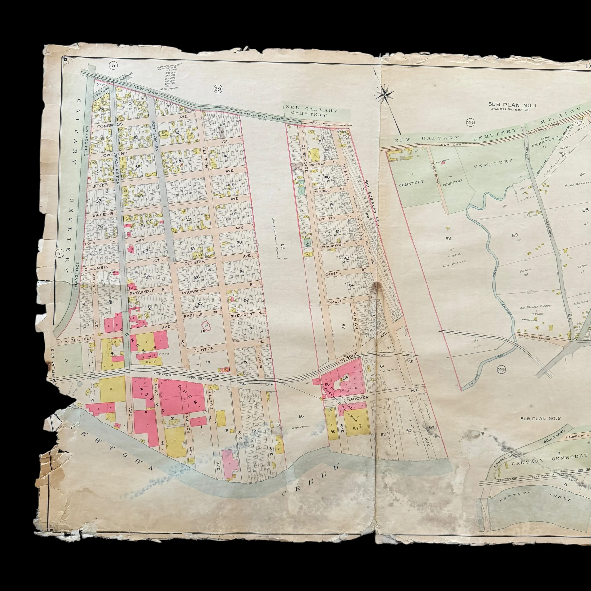
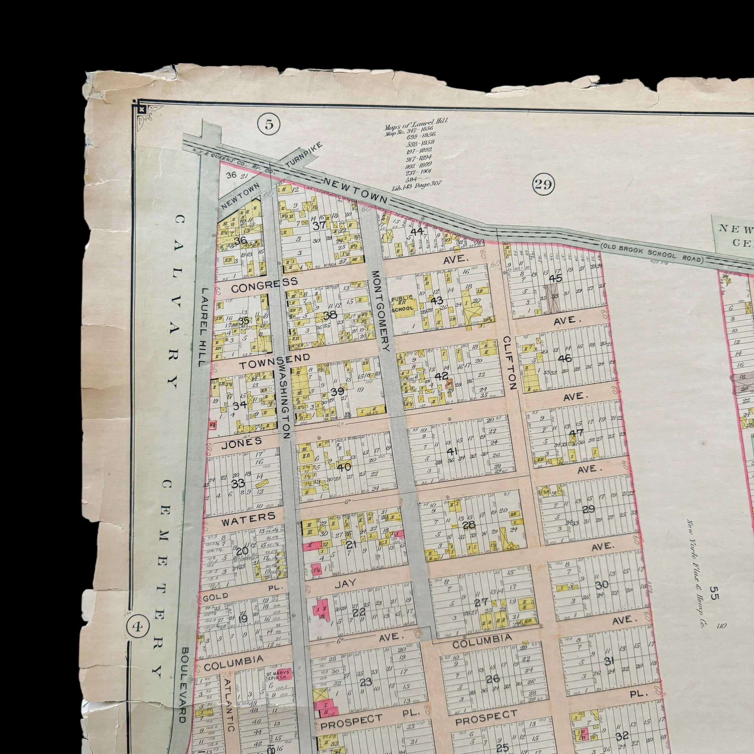
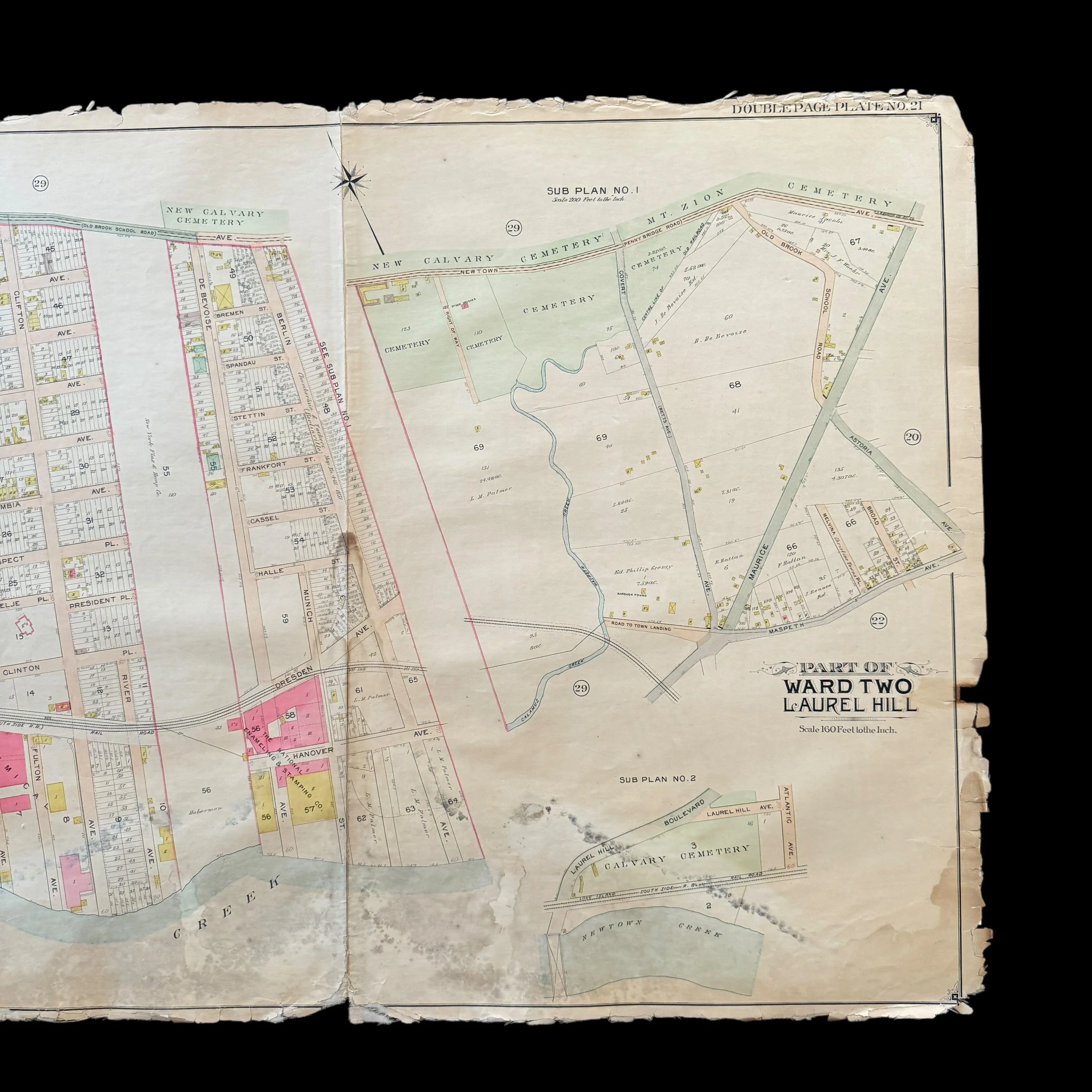
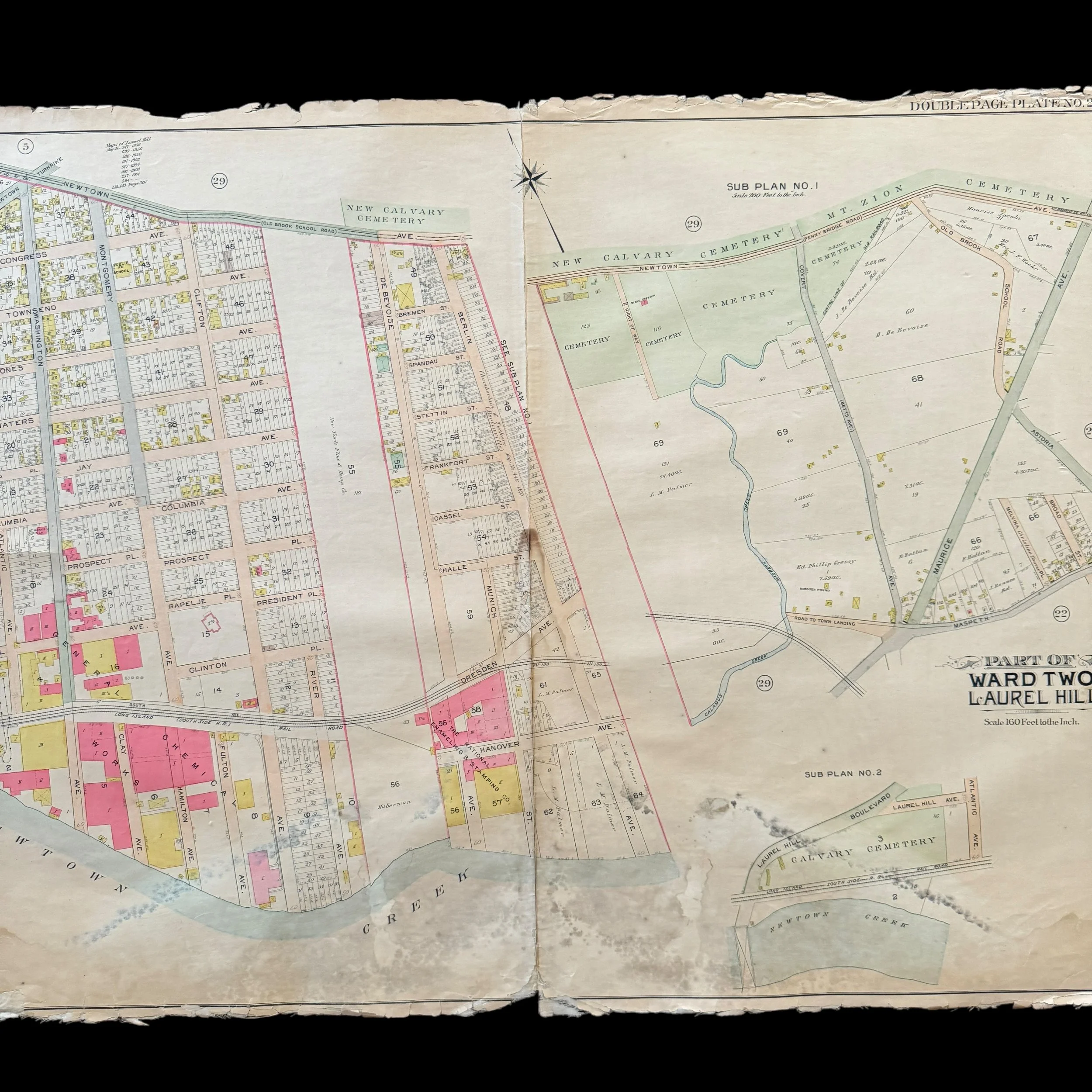
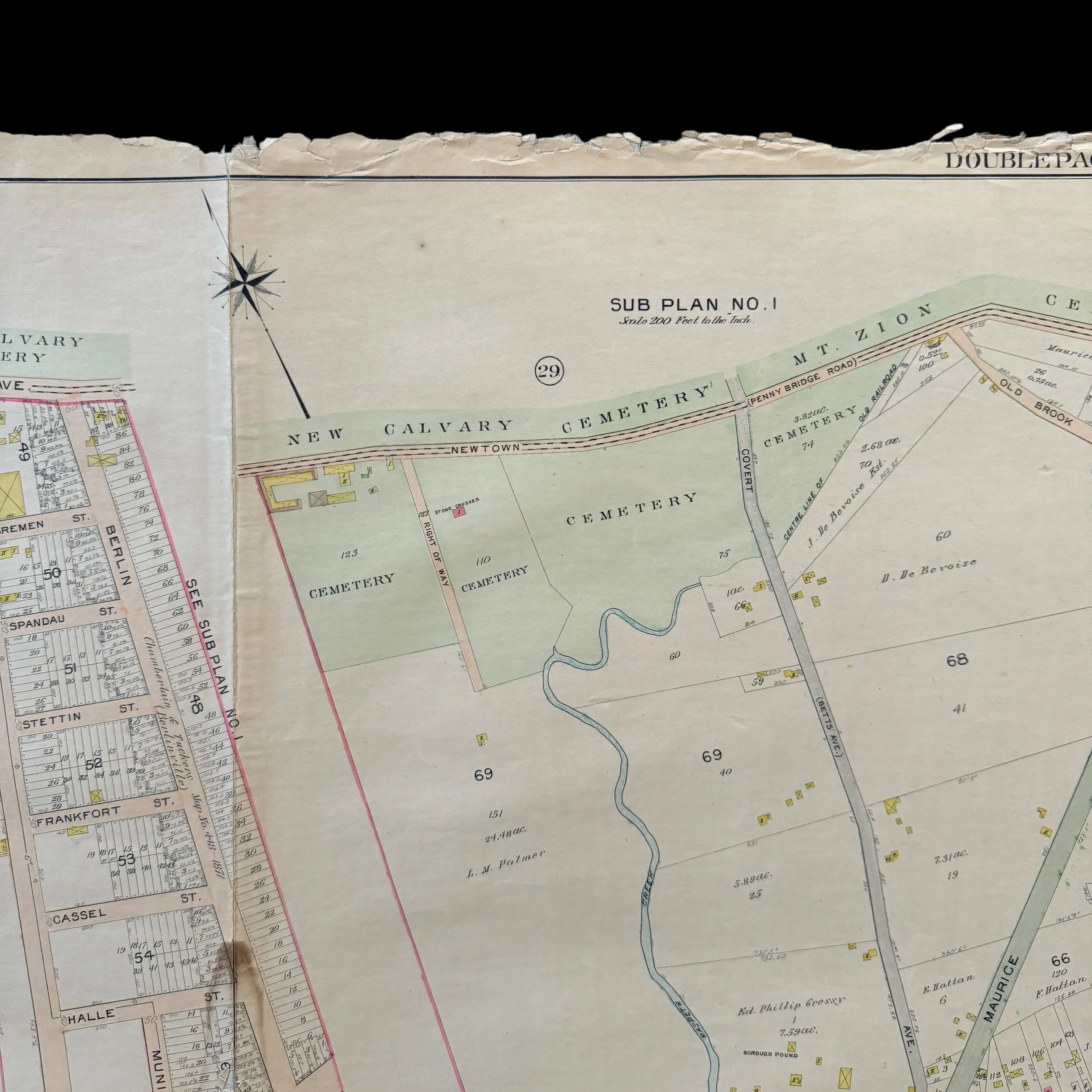
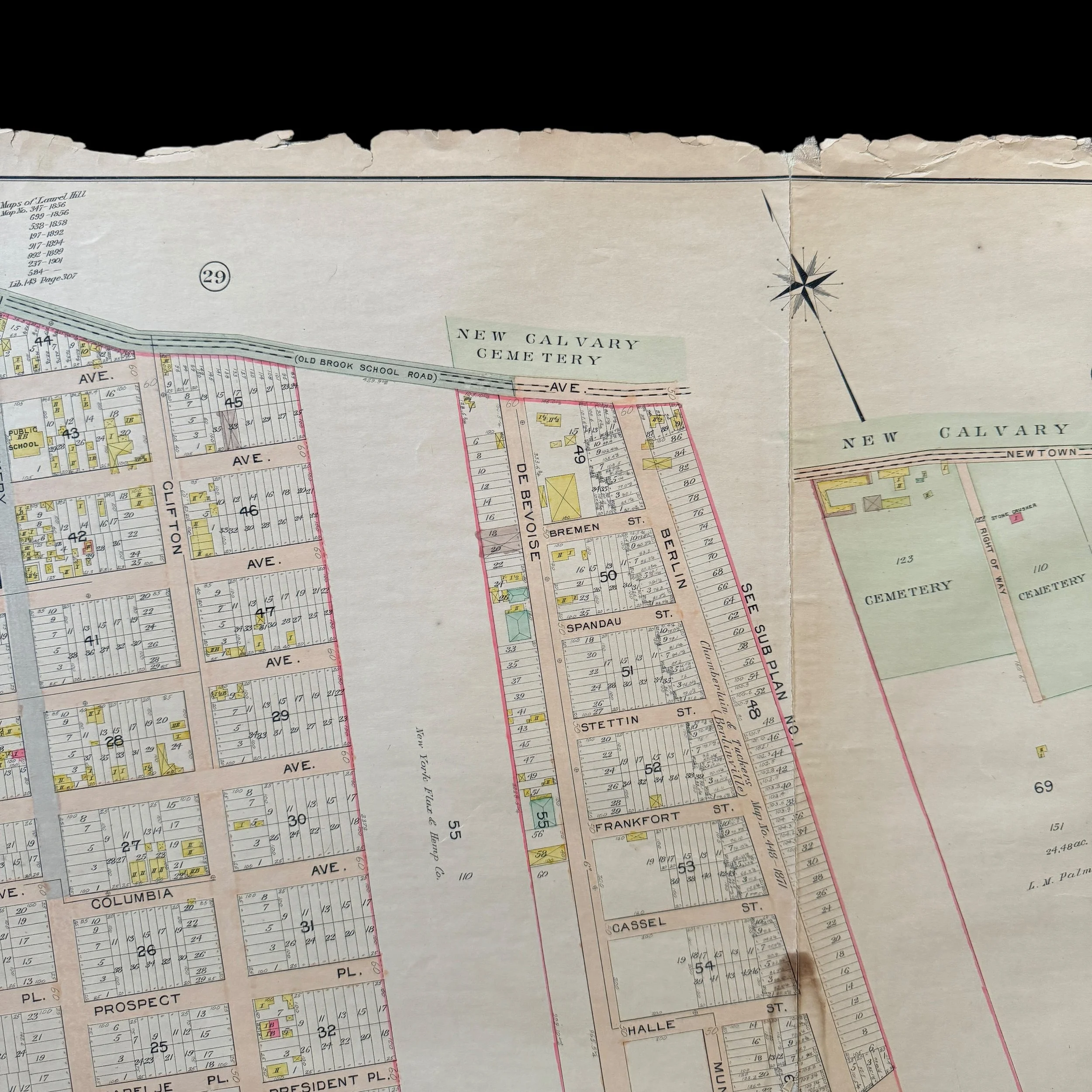

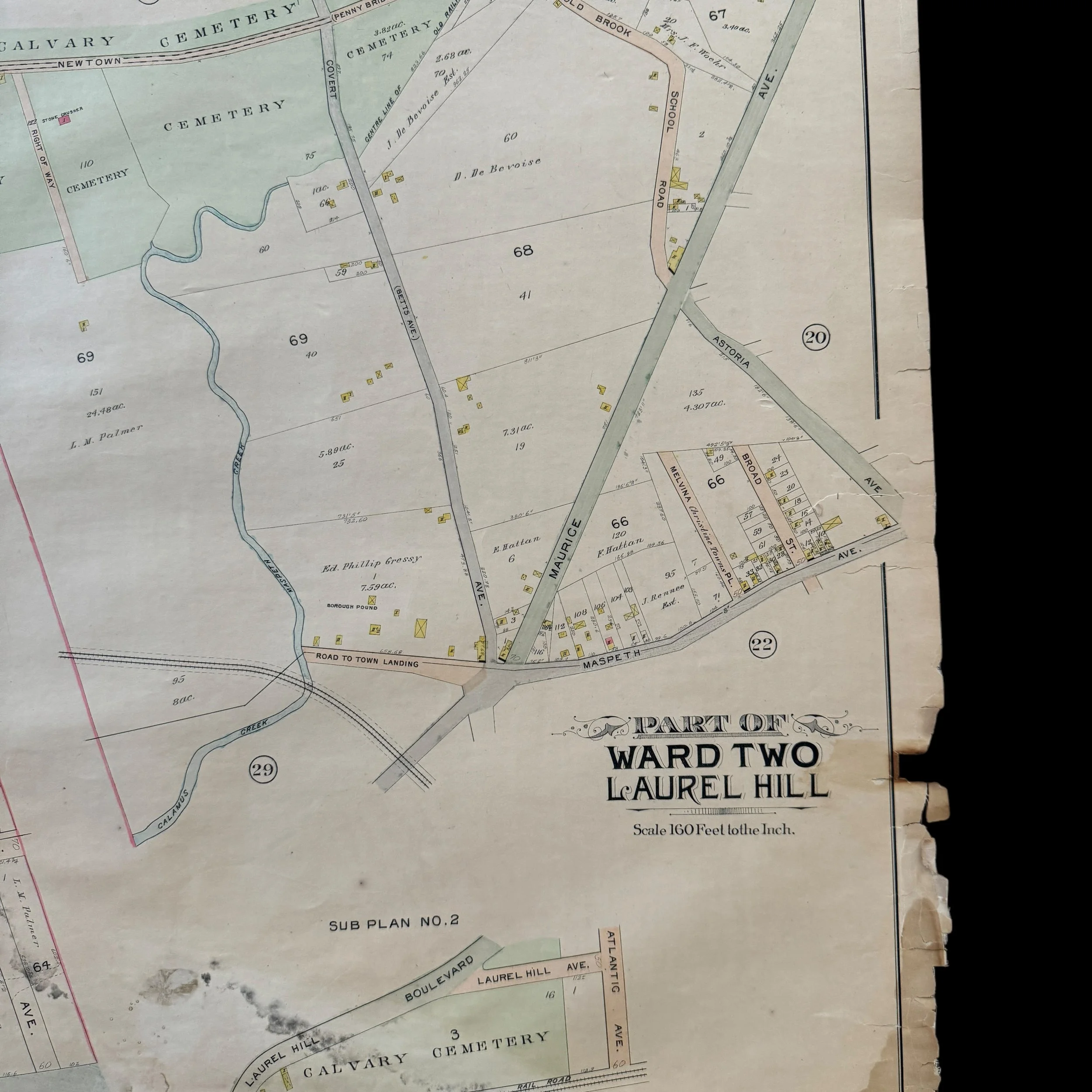
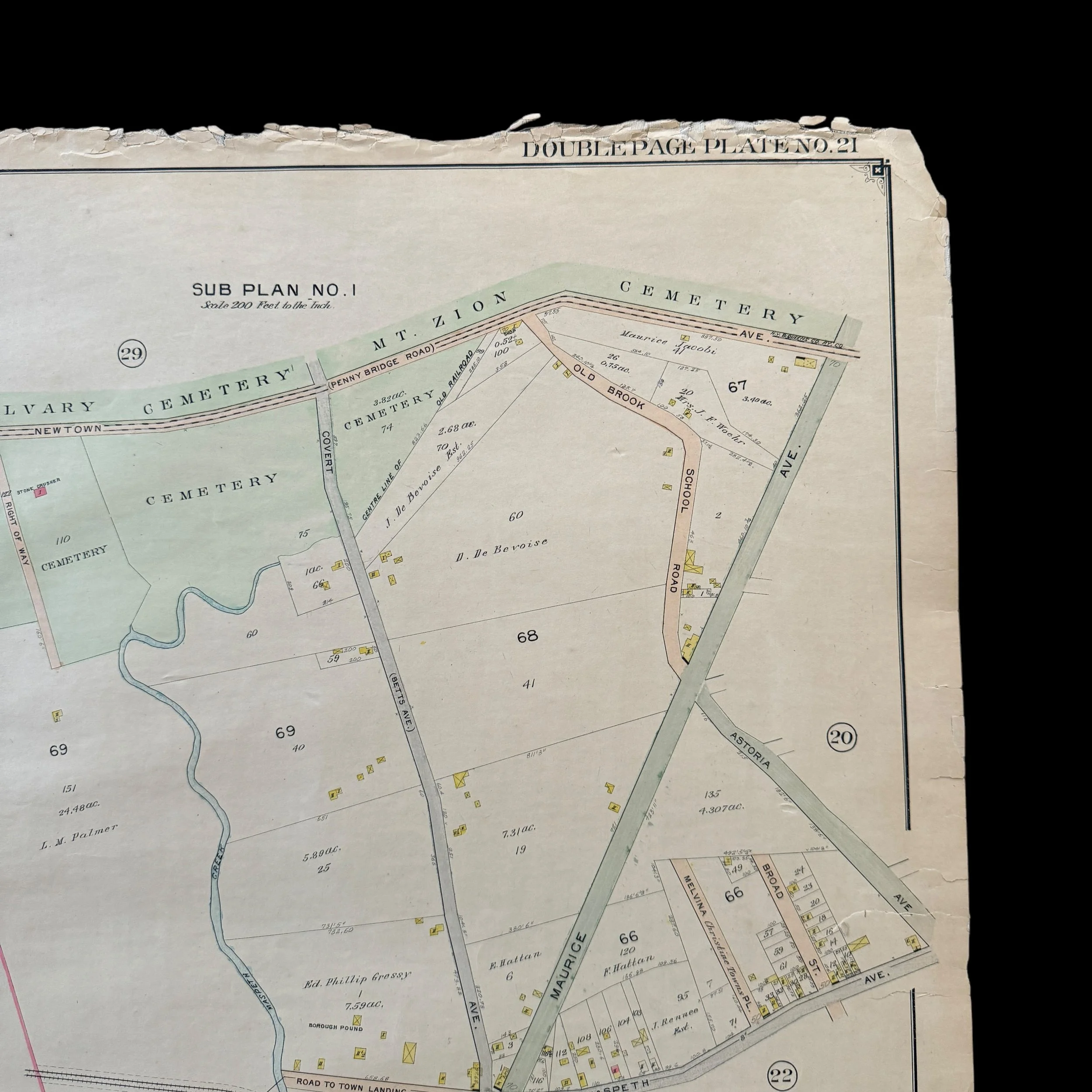
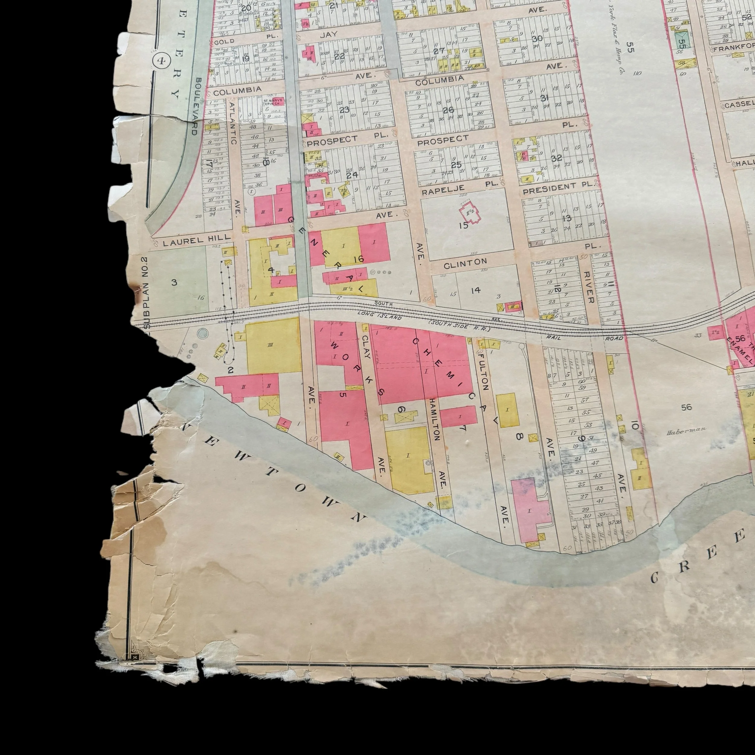
VERY RARE! Original 1903 New York City - Laurel Hill - Long Island City Queens Early 1900's NYC Blueprint Map (PLATE 21)*
Comes with a hand-signed C.O.A.
*This is an extremely rare piece of original early 1900s New York City history that would make a stunning centerpiece in any collection. Framed and displayed, this original 1903 NYC blueprint would not only serve as a captivating conversation piece but also as a tangible link to the city’s past. Its detailed craftsmanship and historical significance make it perfect for anyone passionate about New York City's rich architectural and urban development history. Whether featured in a private collection, office, or historical space, this rare blueprint is sure to become a treasured heirloom that celebrates the evolution of one of the world's greatest cities.
Size: 27 × 37 inches
Dated: 1903
Place: New York - Brooklyn - Queens
Publisher: E. Belcher Hyde
Features: Newtown Ave., Berlin Ave., Newtown Creek; Including Laurel Hill Ave., Laurel Hill Boulevard]; Sub Plan No. 1; [Map bounded by Newtown Ave., Maurice Ave., Old Brook School Road, Astoria Ave.; Including Maspeth Ave., Calamus Creek, Maspeth Creek]; Sub Plan No. 2; Laurel Hill Boulevard, Laurel Hill Ave., Atlantic Ave., Newtown Creek
This extremely rare, museum-grade artifact from early 1900s New York City is an original 1903 blueprint map that is a heavily used and marked blueprint was created by the renowned cartographer and publisher E. Belcher Hyde, whose detailed real estate and property maps of New York City and Long Island in the late 19th and early 20th centuries are revered for their precision and historical significance.
At more than 100 years old, this original NYC blueprint is part of a larger series that meticulously documented various sections of New York City, including Queens, Brooklyn, and other boroughs. These maps captured the rapid urban development during a time of major transformation for the city.
In 1903, NYC was at the heart of significant change, having been incorporated into Greater New York City just five years earlier in 1898. The area was transitioning from a largely industrial and residential neighborhood into a more integrated part of the bustling metropolis. Detailed blueprints like this one were vital to guiding that development, serving as indispensable tools for real estate professionals, city planners, and developers.
E. Belcher Hyde's blueprint for NYC offered a wealth of information, from property boundaries and building footprints to street layouts, lot numbers, and ownership details. The blueprint also included railways, waterways, and industrial zones, making it an essential resource for planning new developments and infrastructure. These blueprints were not just practical but legal documents, often used to resolve disputes over property lines and land use.
Hyde’s attention to detail and accuracy in cartography ensured that his blueprints reflected the rapidly changing landscape of New York City at the turn of the century. Today, the 1903 blueprint is a valuable historical artifact, offering a detailed glimpse into the urban planning and development of Long Island City during this pivotal era.
Maps published by E. Belcher Hyde are now considered some of the most important historical documents of the time, providing an unparalleled snapshot of New York City’s growth, land use, and infrastructure at the height of their transformation into a global metropolis.
This is truly a once-in-a-lifetime opportunity to own a one-of-a-kind piece of New York City history. This original 1903 E. Belcher Hyde blueprint is the only known version available for purchase in the public sector. With the majority of these rare blueprints held in private museum collections, opportunities like this are exceedingly rare, making this a unique chance to own an authentic artifact of New York’s early 20th-century development.
Laurel Hill, a neighborhood in the western part of Queens, New York City, provides a unique historical perspective on the growth of the outer boroughs during the early 20th century. Known today as part of the greater Long Island City and Maspeth areas, Laurel Hill played an integral role in Queens’ development from a semi-rural landscape to a bustling industrial hub. In the early 1900s, the neighborhood underwent significant transformation driven by the expansion of industry, infrastructure, and transportation networks, all of which reshaped the area and set the stage for its later evolution. Although the name "Laurel Hill" has largely faded from contemporary maps, the area’s legacy endures in the industrial and transportation landscape of modern Queens.
Origins and Early Development
Laurel Hill’s early history is rooted in the Dutch and English colonial periods, with the region originally settled in the 17th century as part of Newtown (later Elmhurst). By the 1800s, Laurel Hill was largely agricultural, but its location on the East River made it ideal for industry and transportation developments, which would prove to be transformative. The name “Laurel Hill” was likely inspired by the picturesque terrain, as was common in the naming of many early American neighborhoods. It remained sparsely populated and rural until the latter part of the 19th century, when the expansion of New York City’s industrial zones into Queens began.
Laurel Hill gained its first industrial foothold in the mid-1800s when factories and warehouses were constructed along Newtown Creek, which formed a natural boundary between Brooklyn and Queens. Newtown Creek was critical for transporting goods and materials, and its presence spurred further industrialization in the surrounding areas, including Laurel Hill. As the need for industrial space increased in Manhattan, more factories and storage facilities relocated to Queens, taking advantage of its proximity and available land.
Infrastructure and Industrial Expansion in the Early 1900s
The early 20th century marked a period of profound change for Laurel Hill, driven by New York City’s expanding infrastructure and a growing demand for industrial spaces. The construction of transportation networks—including the Long Island Rail Road (LIRR) and the opening of new bridges—fueled the rapid industrialization of Queens. Laurel Hill became a focal point for industries due to its strategic position near Newtown Creek and its connectivity to both Brooklyn and Manhattan.
In 1909, the Queensboro Bridge was completed, connecting Queens to Manhattan for the first time. This development was transformative for neighborhoods like Laurel Hill, as it made commuting and goods transportation more efficient. Factories sprang up along the waterfront, and warehouses lined Newtown Creek, turning Laurel Hill into a hive of industrial activity. The area became home to numerous manufacturing plants, including metalworks, chemical factories, and paint manufacturers, all of which were vital to the city’s economy. The proximity to rail lines allowed easy shipment of goods to other parts of New York and beyond, creating a booming industrial economy that drew workers from across the region.
The Influence of Transportation on Development
The expansion of transportation networks had a profound impact on Laurel Hill’s development. The Long Island Rail Road (LIRR) played a significant role in making the area accessible and attractive to industry. In the early 1900s, the LIRR had established multiple lines that passed through Queens, enabling easier commutes for workers and facilitating the transport of raw materials and finished goods. The nearby rail yards in Sunnyside also became a major freight hub, further enhancing the industrial potential of the surrounding neighborhoods.
The presence of Newtown Creek was another critical factor in Laurel Hill’s development. A tidal estuary connecting the East River with the inland neighborhoods of Brooklyn and Queens, Newtown Creek became a significant transportation artery. In the early 1900s, it was heavily trafficked by barges and cargo vessels, providing factories with direct water access. Many of these factories built piers and docks along the creek, allowing goods to be shipped in and out with relative ease. This waterway access allowed Laurel Hill to develop a robust industrial economy, as industries could capitalize on both the rail and water transportation systems available to them.
Community and Living Conditions
While Laurel Hill was predominantly industrial, it also hosted a small residential community, largely composed of immigrant laborers who worked in the nearby factories. Many of these residents came from European countries, particularly Ireland, Italy, and Eastern Europe. The neighborhood offered affordable housing near their places of employment, making it an attractive option for working-class families. However, living conditions in early 1900s Laurel Hill were often challenging. The proximity to factories meant that residents were exposed to pollution from industrial activities, including air pollution from smokestacks and chemical runoff into Newtown Creek, which was heavily polluted by this time.
Housing was basic and often crowded, with many families living in tenement-style buildings that were inexpensive but lacked modern amenities. The local community faced difficulties related to poor sanitation and limited access to clean water, as well as the persistent issue of industrial noise. Despite these hardships, the working-class population of Laurel Hill formed tight-knit communities, with social clubs, religious organizations, and family networks providing support in times of need. Churches, particularly Catholic and Eastern Orthodox, served as important centers for social gatherings and mutual assistance, helping residents cope with the demanding and sometimes dangerous nature of industrial labor.
Environmental Impact and Health Concerns
As Laurel Hill grew into a major industrial center, the environmental impact of its factories became increasingly apparent. Newtown Creek, once a valuable natural resource, suffered from severe pollution caused by industrial waste disposal. Factories dumped chemical byproducts and other waste directly into the creek, contaminating the water and contributing to health issues for both workers and residents. By the 1910s, the creek was already one of the most polluted waterways in New York City, an issue that persisted well into the 20th century. The contamination impacted not only the environment but also the health of those living and working in the area, as air and water pollution became pressing concerns.
The pollution of Newtown Creek led to frequent public health issues, with residents suffering from respiratory illnesses and other pollution-related ailments. These conditions made life difficult for those who called Laurel Hill home, but the area's economic importance as an industrial hub meant that little was done to curb industrial pollution until many decades later.
Decline of the Industrial Era and Transition
By the mid-20th century, Laurel Hill, like many industrial areas in New York, began to experience a decline in manufacturing as industries moved elsewhere or closed altogether. Advances in transportation and shifts in the economy made the dense industrial areas of New York less attractive to manufacturers, who sought cheaper land outside the city. As factories closed or moved, employment opportunities dwindled, and the area underwent a gradual transformation.
Despite the industrial downturn, the legacy of Laurel Hill’s early 1900s development is still visible. While much of the heavy industry left by the late 20th century, the infrastructure built during the early 1900s remains an enduring part of Queens’ landscape. Today, the area is dotted with warehouses, distribution centers, and repurposed industrial spaces, some of which have been transformed into modern commercial or residential developments. Newtown Creek continues to be a key environmental issue, with ongoing cleanup efforts aimed at addressing the historical pollution that began during Laurel Hill’s industrial boom.
Legacy of Laurel Hill
Laurel Hill’s history in the early 1900s reflects the broader industrialization and suburban expansion that characterized New York City’s development in this period. The neighborhood's growth was propelled by advances in transportation, the expansion of manufacturing, and the hard work of immigrant communities who formed the backbone of its industrial economy. Although Laurel Hill is no longer an official neighborhood on contemporary maps, its legacy lives on in the industrial districts of Queens and in the memory of the working-class communities that built it.
Laurel Hill's development illustrates the dual forces of progress and environmental degradation that often accompanied industrial growth in early New York City. The factories and warehouses that brought jobs and economic activity also brought pollution and difficult living conditions, a trade-off that defined the experience of many working-class New Yorkers in the early 20th century. Today, as the area continues to evolve, the story of Laurel Hill serves as a reminder of the resilience of the communities that have called this part of Queens home, shaping the neighborhood’s history and identity in the face of significant challenges.
In summary, Laurel Hill’s history in the early 1900s captures the spirit of industrial New York, highlighting the rise of factories, the expansion of transportation networks, and the determination of immigrant communities. Though the neighborhood as it was may no longer exist in name, its contributions to Queens’ economic and social fabric are unmistakable, marking it as an essential chapter in the story of New York City's development.