VERY RARE! WWII 1944 U.S. Allied Field Printed SPECIAL MAP PARIS-BERLIN Captured German Map


VERY RARE! WWII 1944 U.S. Allied Field Printed SPECIAL MAP PARIS-BERLIN Captured German Map
Comes with C.O.A.
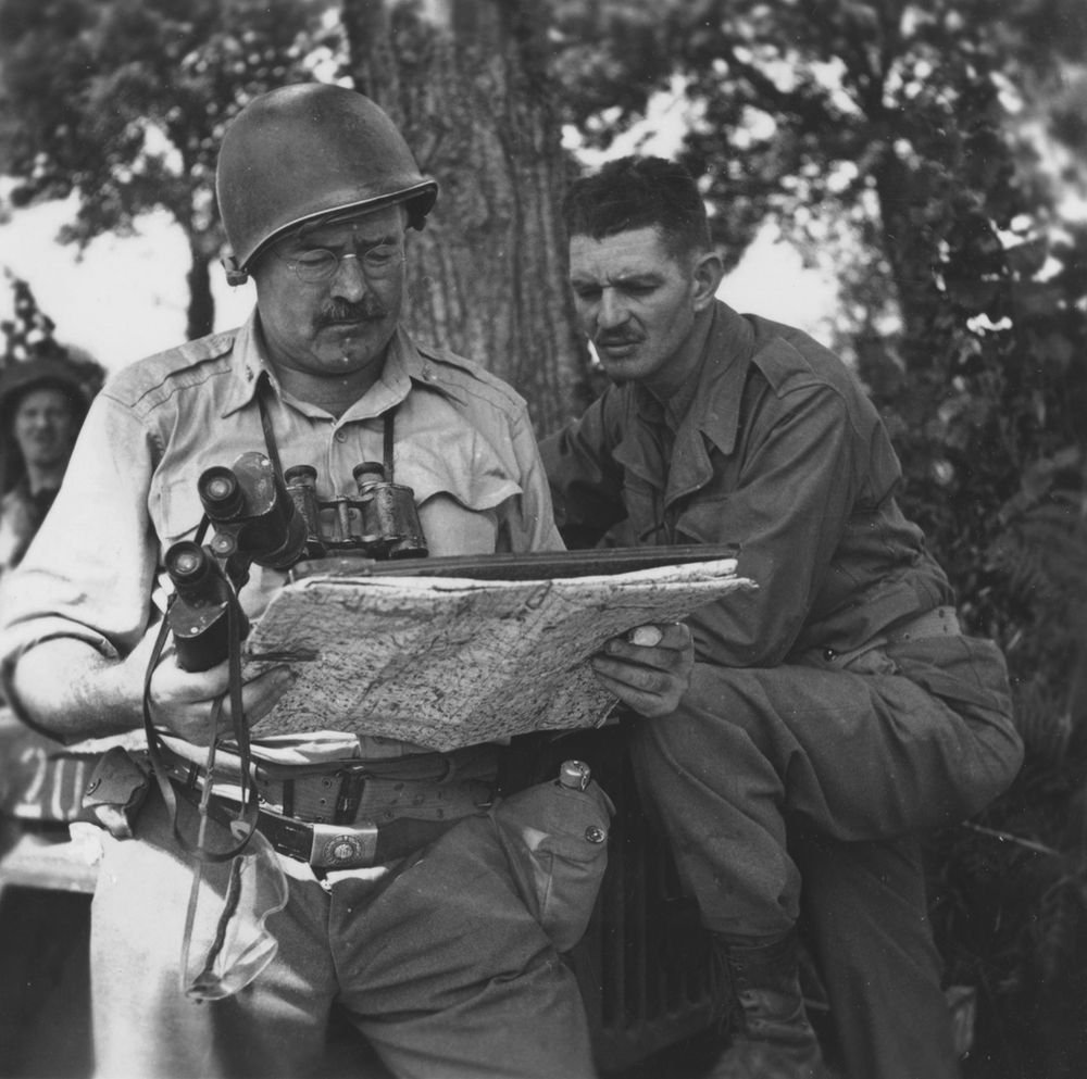
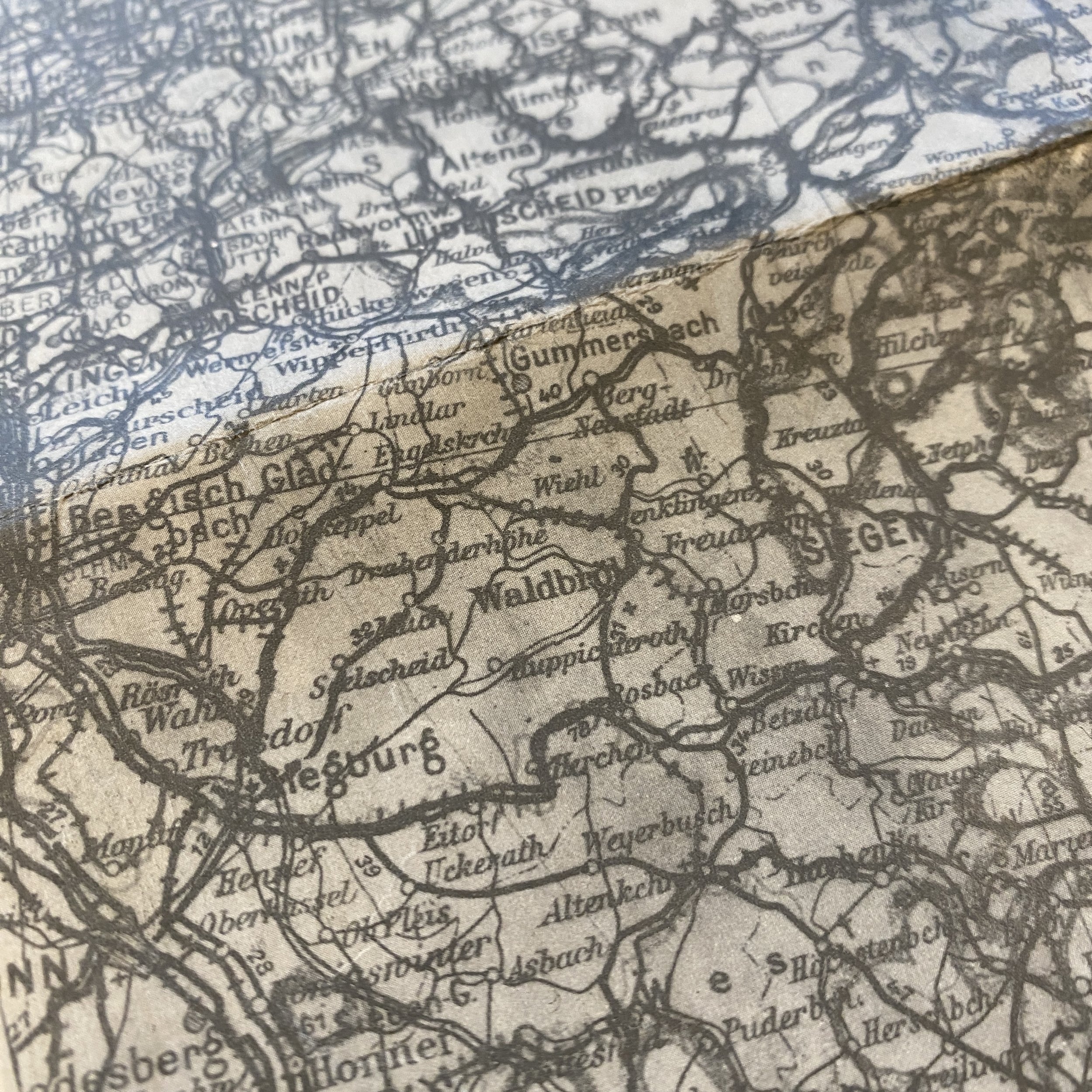
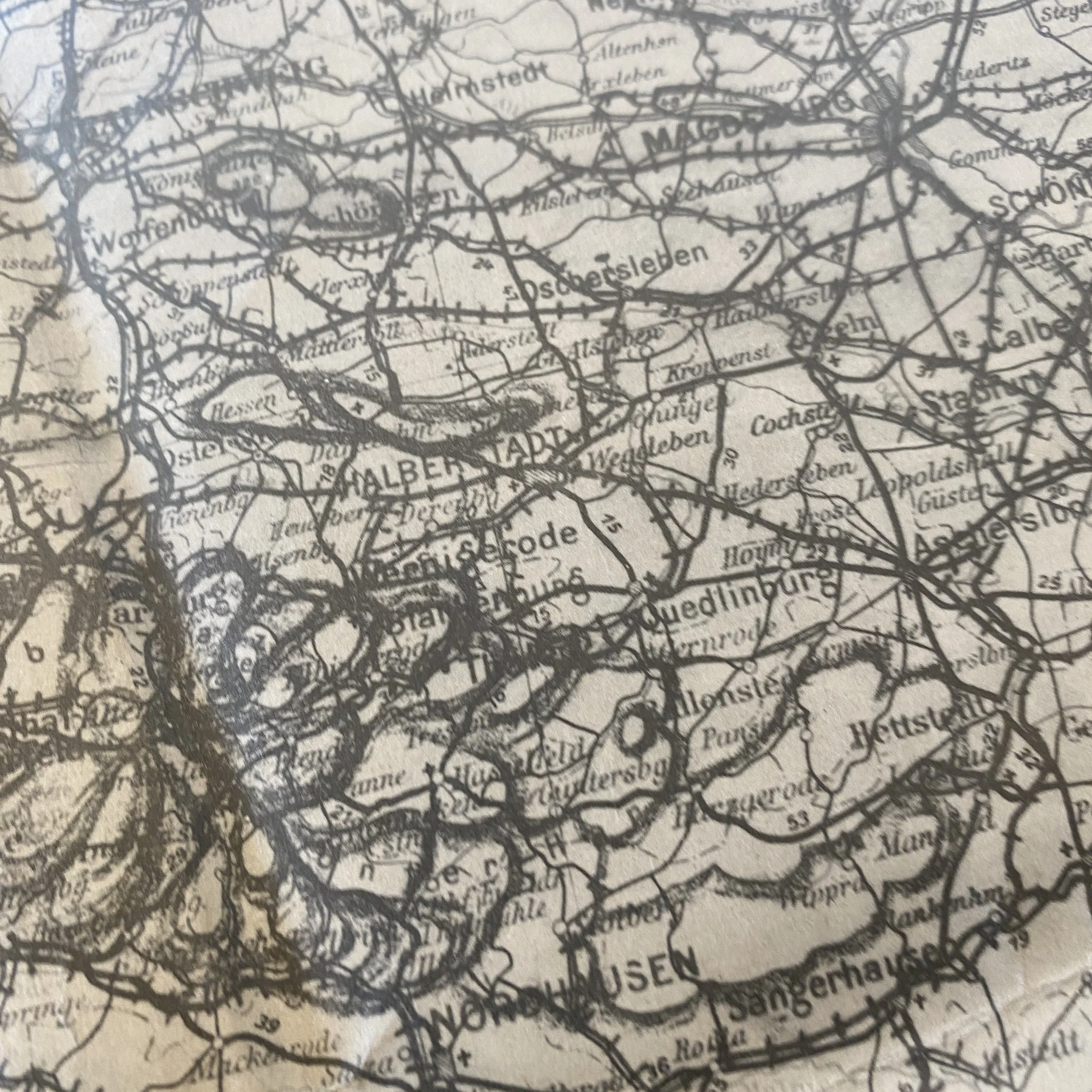
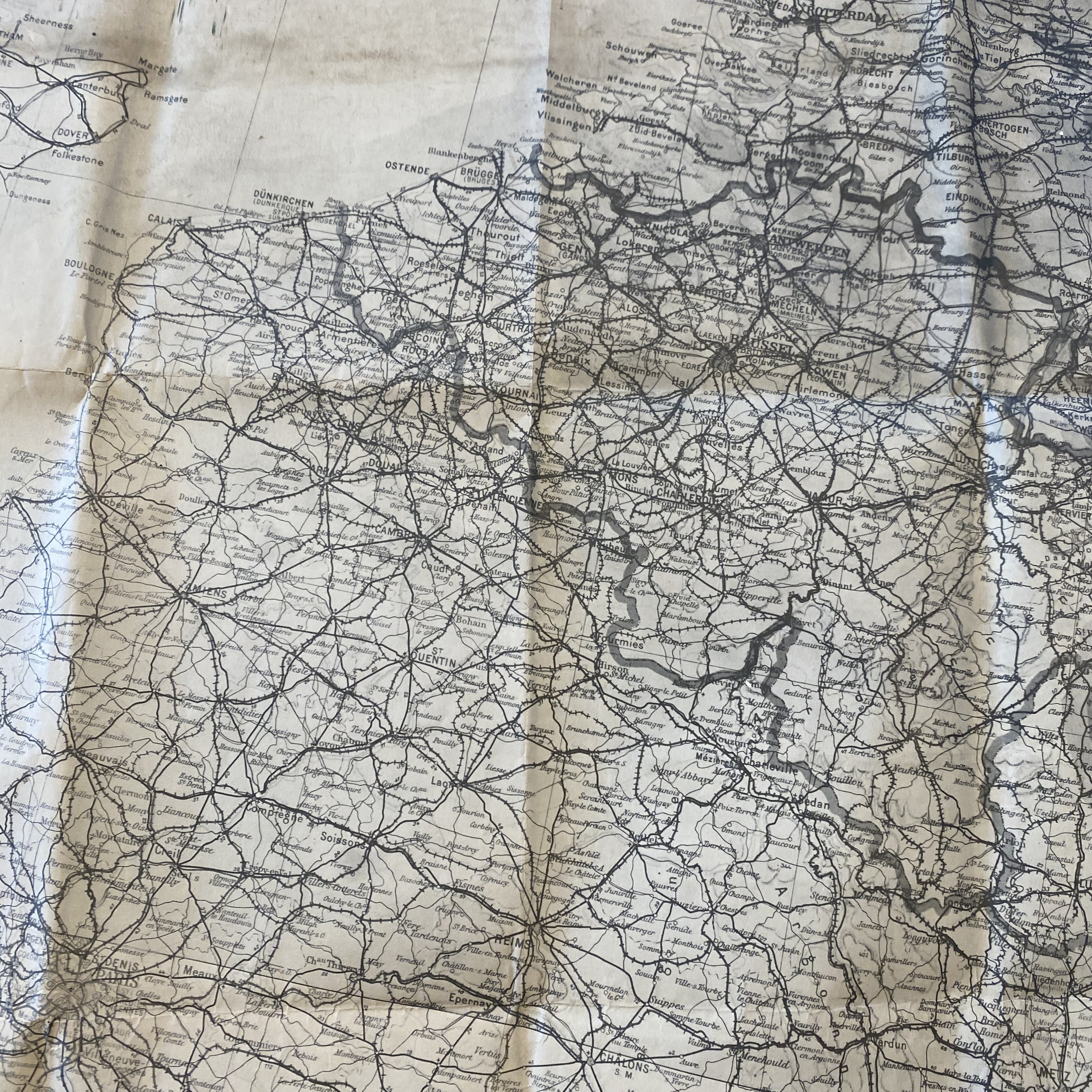
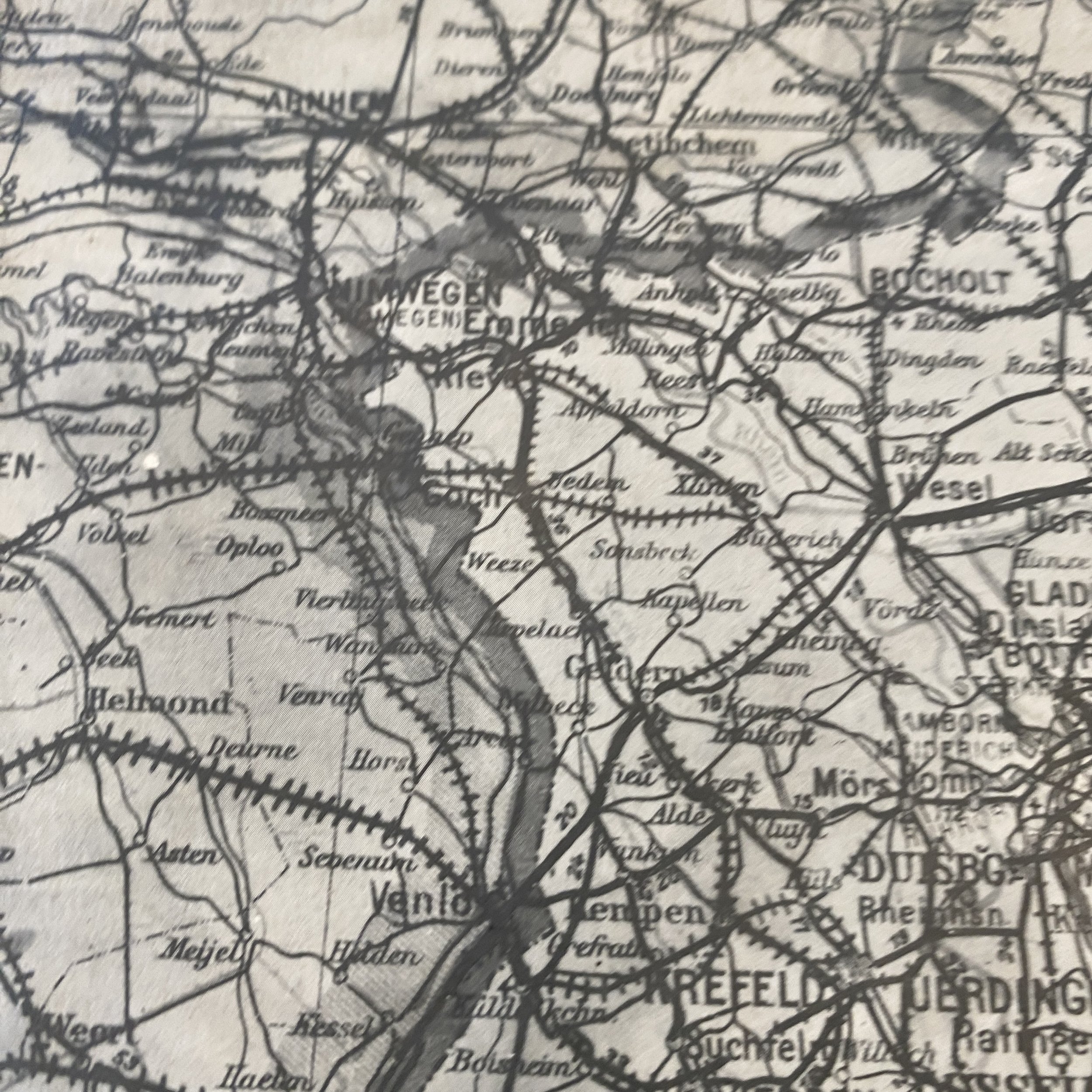
This incredibly rare and museum grade World War II heavily used combat map titled “SPECIAL MAP PARIS-BERLIN” is an extremely rare U.S. field printed map dated 1944. This double sided US Allied map was printed as the US and other allied forces advanced on Paris as well as Belgium, and Germany in later 1944 following the Allied D-Day invasion of Normandy on June 6th, 1944. What makes this extremely limited and very rare map extremely sought after is that this map was created and re-printed from a captured German map.
List of major U.S. and Allied ETO operations this map was used for:
Liberation of Paris (August 19-25, 1944): This operation involved the liberation of the French capital from German occupation by Allied forces, including U.S. troops. General Charles de Gaulle led the Free French Forces, and this operation marked a turning point in the Western European campaign.
Operation Market Garden (September 17-25, 1944): While primarily a British operation, U.S. forces participated in this massive airborne and ground assault into the Netherlands, attempting to secure a series of bridges to advance into Germany. It did not achieve all of its objectives.
Battle of the Bulge (December 16, 1944 - January 25, 1945): This was a major German counteroffensive in the Ardennes region of Belgium, Luxembourg, and France. U.S. forces played a pivotal role in defending against this surprise attack, which ultimately led to the liberation of Bastogne and the eventual push into Germany.
Operation Nordwind (January 1-25, 1945): This was a German counteroffensive in the Alsace region of France and parts of western Germany. U.S. forces were involved in defending against this attack.
Rhineland Campaign (February 8 - March 21, 1945): U.S. forces, along with other Allied units, advanced across the Rhine River into western Germany, making significant progress in the campaign to defeat Germany.
Operation Varsity (March 24, 1945): This was the largest single-day airborne drop in history and was part of the larger Allied crossing of the Rhine River. U.S. forces participated in this operation to secure bridgeheads east of the Rhine.
Western Allied invasion of Germany (late 1944 - May 8, 1945): This is a broader campaign that involved multiple operations and offensives by the Western Allies, including the United States, to advance through Germany and ultimately reach Berlin. These operations included crossing the Rhine, capturing key cities, and dealing with remaining pockets of German resistance.
World War II was a global conflict that demanded unprecedented coordination, innovation, and resourcefulness from the Allied forces. Among the numerous challenges faced during the war, the need for accurate and up-to-date maps was of paramount importance, especially as the Allies advanced through Western Europe following the D-Day landings in Normandy. In the absence of readily available maps, Allied troops turned to field-printed maps, some of which were created using captured German maps. These field-printed maps played a pivotal role in guiding the Allied forces through the complex and constantly changing terrain of Europe, where traditional supply lines were often disrupted, and resources were scarce.
The Necessity of Field-Printed Maps
As Allied forces pushed eastward through Europe after the successful Normandy landings in June 1944, they encountered diverse landscapes and urban environments that were often unfamiliar. The success of military operations depended heavily on having accurate maps that could provide essential information about roads, bridges, rivers, towns, and other geographic features. However, producing traditional maps on a large scale and distributing them to troops in real-time was a logistical challenge, especially as the frontlines shifted rapidly.
Moreover, the wartime destruction of infrastructure, including transportation and communication networks, made it difficult to maintain a steady supply of printed maps. Therefore, field-printed maps became an invaluable solution to address these challenges. These maps could be quickly generated with available resources and tailored to the specific needs of the advancing troops.
Captured German Maps as a Resource
One of the ingenious sources for field-printed maps was captured German maps. The German military was known for its meticulous cartography, and they had detailed maps of various European regions. When Allied forces captured German territories or depots, they seized valuable cartographic resources that could be repurposed for their own use.
These captured German maps had several advantages:
Accuracy: German maps were renowned for their precision and detail. They contained valuable information on terrain, infrastructure, and potential defensive positions, making them highly valuable for the Allies.
Familiarity with Enemy Territory: As the Allies advanced through German-occupied territories, captured maps allowed them to become intimately acquainted with the regions they were conquering, helping them plan strategic movements and avoid potential pitfalls.
Resource Efficiency: Printing new maps from scratch required valuable resources, such as paper and ink. By repurposing existing maps, the Allies could conserve these resources for other critical needs.
Speed of Production: Field-printed maps using captured German maps as templates could be produced rapidly and deployed to front-line units quickly, ensuring that troops had the most up-to-date information.
Customization: The Allies could annotate the captured maps with their own markings, adding critical information such as troop positions, minefields, and obstacles to help navigate and coordinate military operations effectively.
The Process of Field-Printing Maps
Creating field-printed maps involved several steps:
Map Selection: Captured German maps were selected based on the region of operation and the specific needs of the advancing forces.
Reproduction: Field-printing units would reproduce the selected maps using available printing equipment. This could involve the use of mobile printing presses or even improvised methods, such as stencil duplication.
Annotation: Once printed, the maps were annotated to include updated information, such as friendly and enemy positions, road conditions, and tactical markings.
Distribution: The newly created field-printed maps were distributed to the units that needed them most, often to front-line troops and reconnaissance teams.
Importance and Impact
Field-printed maps had a profound impact on the success of Allied operations following the D-Day landings. They played a crucial role in numerous aspects of military strategy and execution:
Tactical Advantage: Accurate maps provided a significant tactical advantage, allowing commanders to make informed decisions about troop movements and engagements with enemy forces.
Maneuverability: Field-printed maps facilitated rapid and precise maneuvers, enabling the Allies to exploit weaknesses in German defenses and respond quickly to changing situations.
Reduced Risk: Detailed maps helped reduce the risk of ambushes, navigational errors, and friendly fire incidents, which were critical in minimizing casualties.
Psychological Boost: Armed with up-to-date maps, soldiers had greater confidence in their abilities and the strategies employed, boosting morale on the frontlines.
In the tumultuous theater of World War II, field-printed maps created from captured German maps emerged as an essential tool for the Allied forces advancing through Western Europe. These maps provided accurate, up-to-date information that was vital for planning and executing military operations. The ability to adapt and produce maps in the field using available resources was instrumental in maintaining the momentum of the Allied advance towards Germany, especially when traditional supply lines were disrupted and resources were scarce.
Field-printed maps not only highlighted the resourcefulness of the Allied forces but also demonstrated the importance of adaptability and innovation in wartime. They served as a testament to the determination and ingenuity of the men and women who fought in World War II and the critical role that geographic information played in their ultimate victory.