RARE! WWII 1944 Dated 10th Reconnaissance Photographic Group (9th Air Force) European Theater Aerial Reconnaissance Mission Photograph*


RARE! WWII 1944 Dated 10th Reconnaissance Photographic Group (9th Air Force) European Theater Aerial Reconnaissance Mission Photograph*
Comes with a hand-signed C.O.A. and a full historical write-up research document
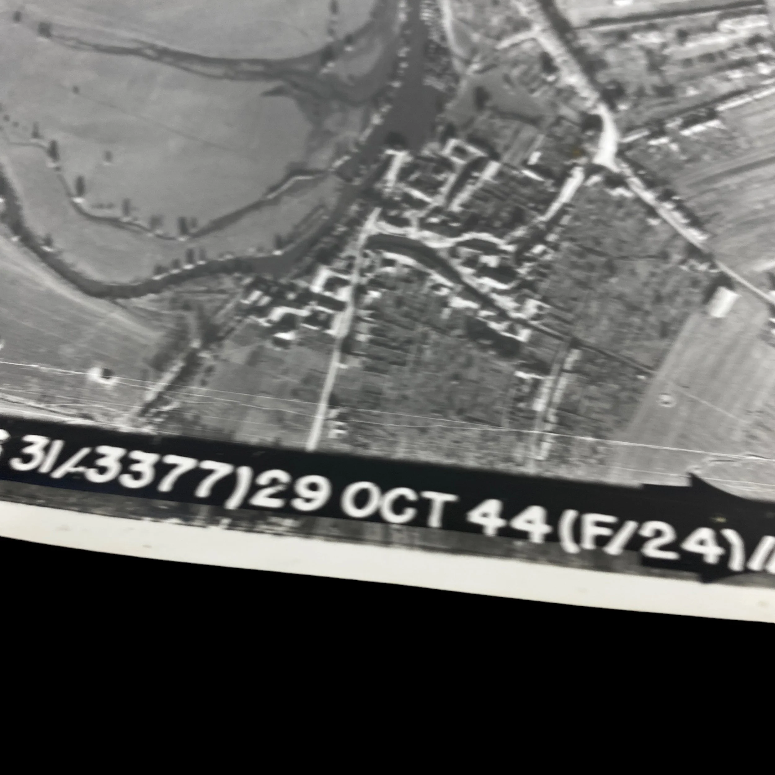
Mission Date: October 29th, 1944
10th Photogroup Campaigns. American Theater; Air Offensive, Europe; Normandy; Northern France; Rhineland; Ardennes-Alsace; Central Europe.
Decorations. Distinguished Unit Citation: France, 6-20 May 1944.
This incredibly rare and museum-grade World War II European Theater Allied aerial reconnaissance mission photograph was taken by one of the most decorated Tactical Reconnaissance Groups of the European Theater. The U.S. 10th Photographic Group (Reconnaissance) of the Ninth Air Force used F-3, F-5, F-6, L-1, L-4, and L-5 aircraft for their aerial recon missions on the ETO. From February 1944 to May 1945 the 10th Photographic Group flew SECRET aerial recon mission to photograph German airfields, coastal defences, and ports, and made bomb-damage assessment photographs of airfields, marshalling yards, bridges, and other targets.
In preparation for the D-Day Normandy invasion on June 6th, 1944 the 10th Photographic Group received a DUC for flying at low altitude to photograph the coast from Blankenberghe to Dunkirk and from Le Touquet to St-Vaast-la-Hougue from 6-20 May 1944. The 10th Photographic Group went on to support the Operation Overlord D-Day invasion in June by making visual and photographic reconnaissance of France bridges, artillery, road and railroad junctions, traffic centers, airfields, and other targets. The 10th Photographic Group continued to provide the most accurate and updated aerial recon photos to Allied high command as the Allies drove toward the German border during the summer and early fall of 1944. It was here the 10th Photographic Group flew daylight and night photographic missions. They also performed tactical reconnaissance for ground and air units, directing artillery to enemy positions and fighter bombers to opportune targets. The 10th Photographic Group aided the Third Army and other Allied organizations in the battle to breach the Siegfried Line from Sep-Dec 1944. The 10th Photographic Group participated in the Battle of the Bulge from Dec 1944 to Jan 1945, by flying reconnaissance missions in the combat zone. From Feb 1945 to V-E Day, the 10th Photographic Group went on to assist the advance of Third Army across the Rhine, to Czechoslovakia, and into Austria.
This aerial photofraph provided Allied commanders, high-ranking officers, and intelligence officials with vital intelligence information that they used to direct future bombing missions and strategical advantages to out-guess the enemy. Thousands of pilots and aircrew throughout the war risked their lives to take photographs such as this one right here. During World War Two, aerial reconnaissance was one of the key methods of obtaining intelligence about the enemy and their activities. Photographs provided concrete evidence - fast. Within hours of a reconnaissance sortie, the film could be developed, printed and interpreted. Allied reconnaissance, for the most part, was classified under two main headings: mapping and damage assessment. Enemy activity was recorded and new installations were located, so that accurate maps, to be used by the ground forces, could be made. From damage assessment photographs, the exact moment when a target that had been previously hit should be re-attacked could be calculated, and the effectiveness of the enemy's rebuilding programme could be assessed. Photographic reconnaissance and intelligence work played a tremendous role in helping the Allies to victory in World War Two. Significantly, in 1938 General Werner Von Fritsch of the German High Command prophetically observed: 'The military organisation with the best aerial reconnaissance will win the next war.'
Full Combat History of the 10th Photo Group:
The 10th Reconnaissance Group served with the Ninth Air Force in Europe from May 1944 until the end of the fighting, helping to support the D-Day landings, the advance across France and the invasion of Germany. The group was originally formed as the 73rd Observation Group in August 1941. It spent several years based in the United States, taking part in the Tennessee Manoeuvres of 1943 and preparing for action overseas. During this period the group changed name several times, becoming the 10th Photographic Group (Reconnaissance) in December 1943. In January-February 1944 the group moved to Europe to join the Ninth Air Force, entering combat in February. At that stage it contained the 30th and 39th Photographic Reconnaissance Squadrons, but it quickly expanded. In March the 31st and 34th joined although the 39th left. In May the 33rd and 155th joining, bringing it up to five squadrons. In June 1944 the group lost the 30th and 33rd but gained the 12th and 15th. The 34th went in October 1944, reducing to four squadrons. In February 1945 it gained the 39th but lost the 155th. In March it lost the 39th and in April it briefly gained the 162nd. The group was heavily involved in the preparations for the D-Day landings. In May it flew ten particularly dangerous missions to take very low level photos of the landing beaches and nearby shallow waters, in an attempt to map out the underwater obstacles being built. These were flow from as little as 15ft, and won the unit a Presidential unit citation (as well as costing the life of one pilot). The group also photographed German installations along and just behind wide areas of the French coast. During the D-Day assault itself the group helped direct naval gunfire and also covered vital German transport links. By the end of July 1944 the group had completed the move to France. The unit took part in the siege of Brest (August-September 1944), helping to direct the Allied artillery fire. During the breakout from Normandy the group helped support the advancing troops, once again directly artillery fire onto German targets. In September-December 1944 the group was used to support the Third Army as it attacked the German western fortifications of the Siegfried Line. In the period before the battle of the Bulge the group spotted some German movement behind their lines, but not enough to reveal the upcoming attack. Poor weather limited their efforts in early December, stopping all flying on four days. Once the attack began the group was used over the battle area. By 1945 the group's main task was to direct the fighter-bombers and medium bombers that were roaming behind German lines, supporting the advance of the Third Army into southern Germany, Austria and Czechoslovakia.
Main Bases:
Chalgrove, England: Feb 1944
Rennes/St- Jacques, France: c. 11 Aug 1944
Chateaudun, France: c. 24 Aug 1944
St-Dizier/ Robinson, France: Sep 1944
Conflans/ Doncourt, France: Nov 1944
Trier/Evren, Germany: Mar 1945
Ober Olm, Germany: c. 5 Apr 1945
Furth, Germany: c. 28 Apr 1945
Full History of WWII Aerial Photographs:
World War II stands as one of the most pivotal moments in human history, with its impact reverberating across the globe for decades to come. Amidst the tumultuous battles and strategies of this era, aerial reconnaissance emerged as a critical tool that would prove instrumental in shaping the course of the conflict. The Allied forces, recognizing its potential, harnessed the power of aerial photography to gather intelligence, make informed decisions, and ultimately secure victory against their adversaries.
Aerial reconnaissance, the practice of obtaining visual information from the skies, rapidly established itself as an essential method of gathering intelligence during World War II. The speed and accuracy with which reconnaissance photographs could be obtained and analyzed revolutionized the way military operations were conducted. The European Theater, where Allied forces clashed with the Axis powers, witnessed the extensive utilization of aerial reconnaissance photographs that played a decisive role in shaping strategic decisions.
At its core, Allied aerial reconnaissance in World War II can be classified into two primary categories: mapping and damage assessment. Mapping involved capturing high-resolution images of enemy territories to create accurate and up-to-date maps. These maps proved invaluable for ground forces, enabling them to navigate and strategize effectively in unfamiliar terrain. The rapidity with which aerial reconnaissance photos could be developed and interpreted meant that front-line troops could receive critical geographical information within hours of the photographs being taken. This ability to promptly supply accurate maps endowed Allied commanders with a substantial advantage, facilitating swift and decisive movements across the battlefield.
Beyond mapping, damage assessment was another vital application of aerial reconnaissance. As targets were attacked by Allied forces, aerial photographs captured the destruction and allowed analysts to evaluate the extent of the damage inflicted on enemy installations, such as factories, supply lines, and infrastructure. This capability not only aided in gauging the effectiveness of previous strikes but also helped determine when a target should be re-attacked. The ability to time subsequent strikes accurately based on the analysis of reconnaissance photographs was a crucial aspect of optimizing offensive efforts and weakening the enemy's ability to rebuild and regroup.
The significance of photographic reconnaissance and intelligence work during World War II cannot be overstated. One of the most remarkable aspects was the speed at which valuable information could be obtained and disseminated. Within hours of a reconnaissance mission, film could be developed, prints produced, and photographs analyzed. This level of efficiency provided commanders with a near-real-time understanding of enemy movements, installations, and strengths, enabling them to adapt their strategies swiftly.
In the European Theater, where the conflict unfolded on a grand scale, aerial reconnaissance proved to be a game-changer. The landscapes across Western Europe were diverse, ranging from densely populated cities to vast rural expanses. Aerial photographs allowed Allied forces to comprehend the lay of the land, which was especially crucial during the Normandy invasion in 1944. The famous Operation Overlord, which marked the Allied landing in Normandy, was meticulously planned with the aid of reconnaissance photographs. These images provided invaluable insights into the geography, terrain, and enemy fortifications, facilitating the strategic decisions that led to the successful establishment of a beachhead and the eventual liberation of Western Europe.
General Werner Von Fritsch's observation in 1938, that the military organization with superior aerial reconnaissance would triumph in the next war, echoed with prophetic accuracy throughout World War II. The Allies embraced this principle wholeheartedly, harnessing the power of aerial photography to gain a decisive edge over their adversaries. By diligently cataloging enemy activities, locating new installations, and assessing damages, they ensured that their strategic decisions were informed by concrete evidence. The intelligence derived from reconnaissance photographs enabled them to allocate resources effectively, target key enemy assets, and adjust their tactics swiftly in response to changing circumstances.
In conclusion, World War II Allied aerial reconnaissance photographs stand as a testament to the potency of intelligence-gathering methods in shaping the course of history. The swift acquisition, analysis, and utilization of visual information from the skies enabled the Allies to make informed decisions and secure victory against formidable odds. Through mapping and damage assessment, they gained a critical advantage on the battlefield, optimizing their strategies and hastening the path to triumph. The legacy of their pioneering efforts in aerial reconnaissance continues to reverberate in the annals of military history, demonstrating the pivotal role that intelligence-gathering techniques play in shaping the outcomes of conflict.