VERY RARE! Original 1903 New York City - Glendale & St. James Park - Early 1900's NYC Blueprint Map (PLATE 25)*
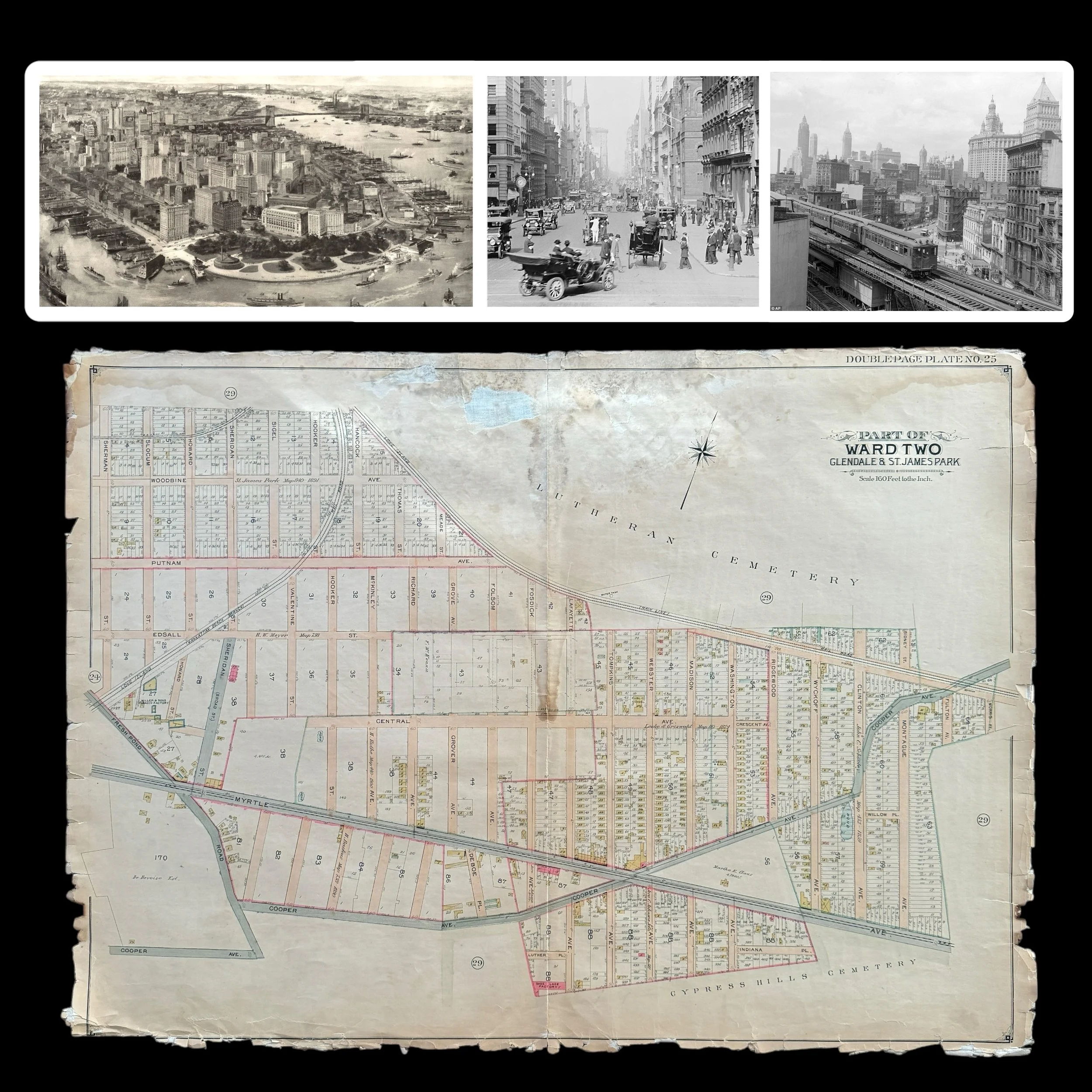
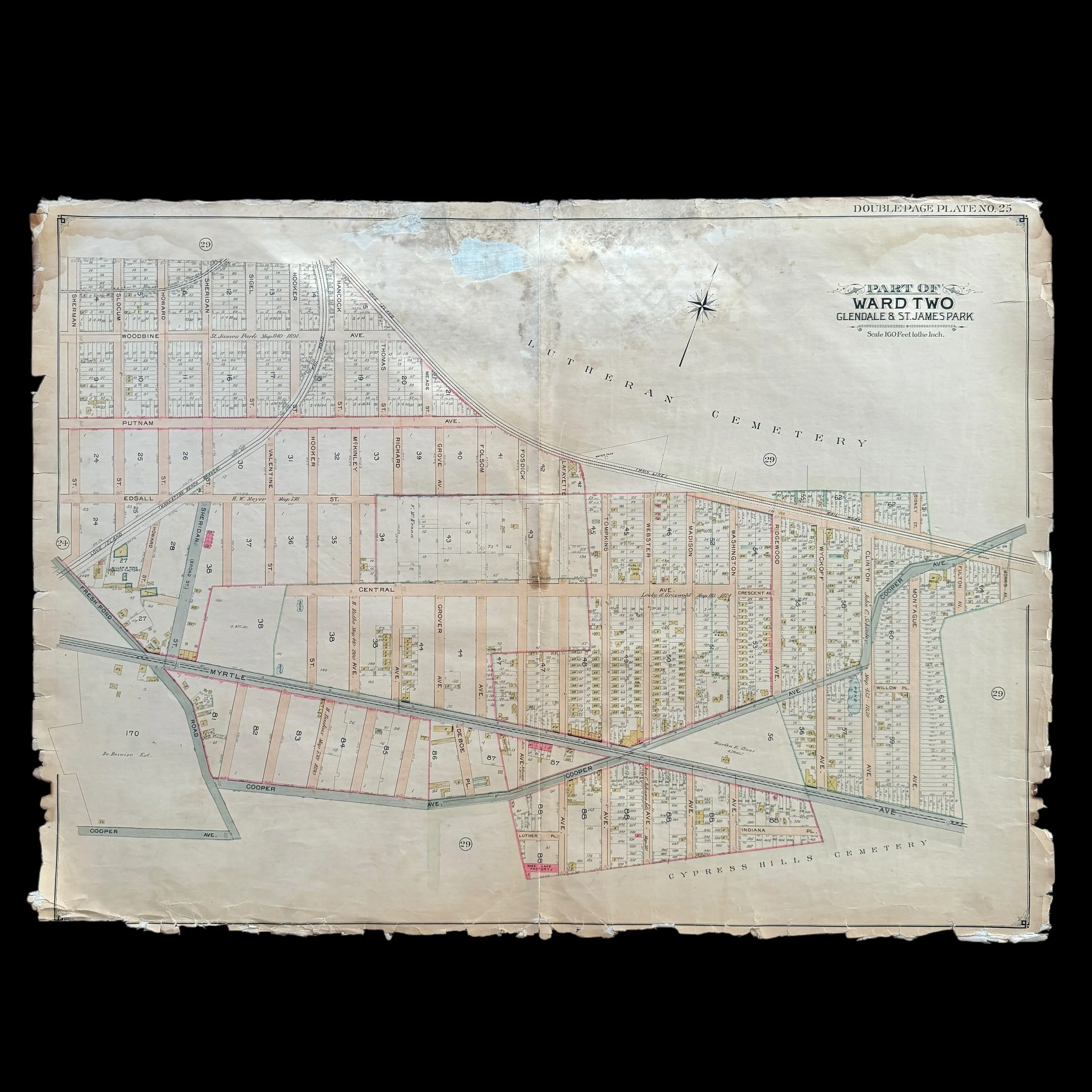
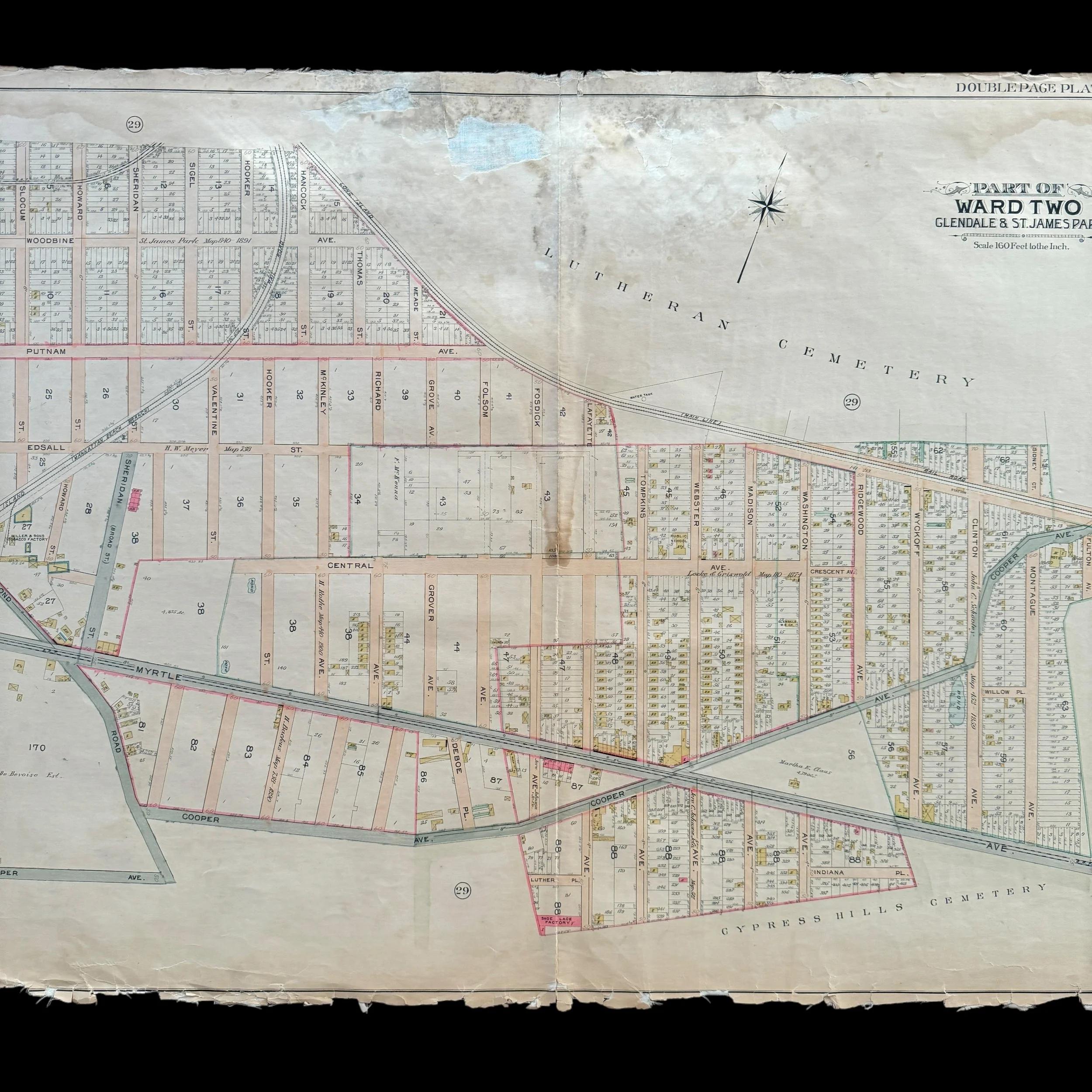
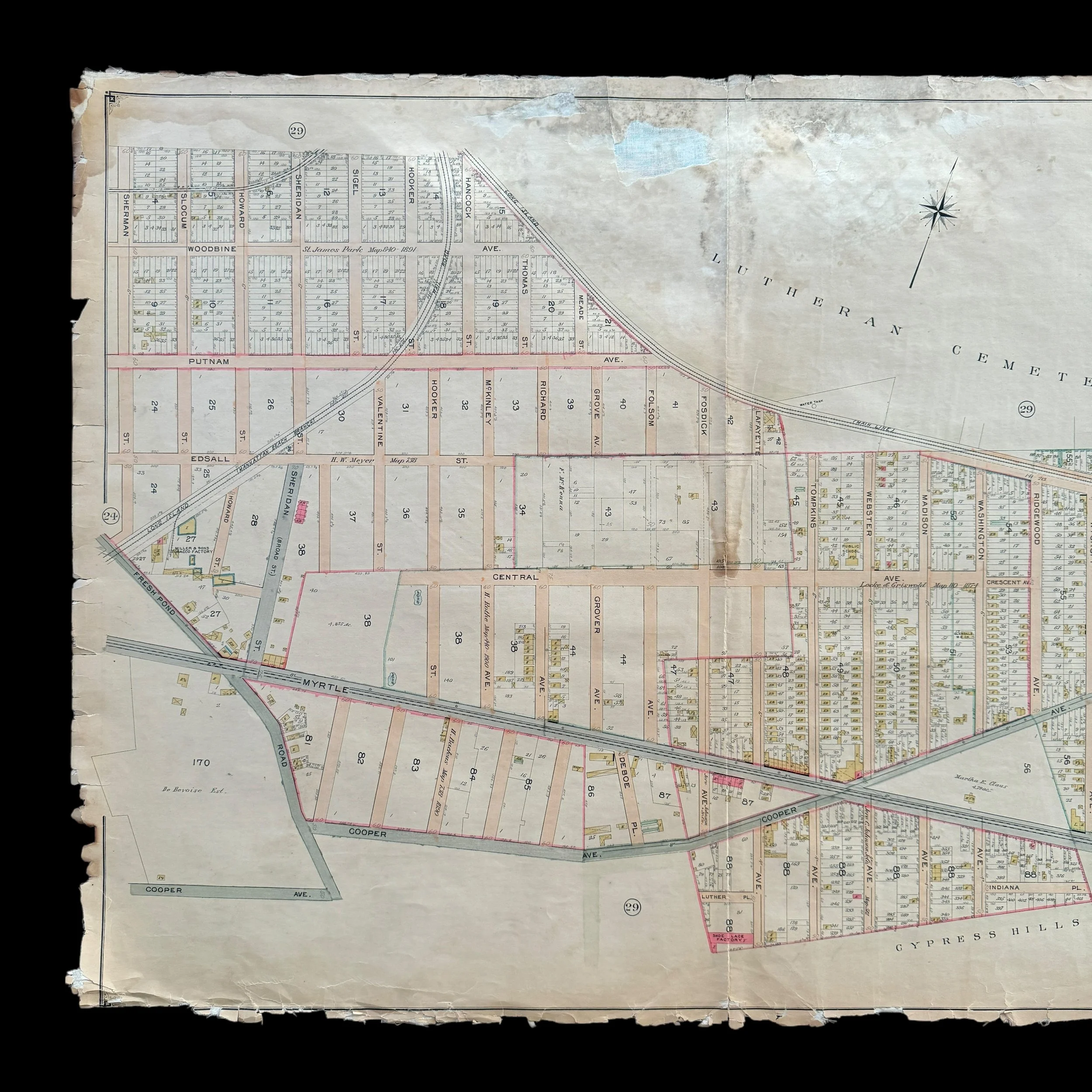


VERY RARE! Original 1903 New York City - Glendale & St. James Park - Early 1900's NYC Blueprint Map (PLATE 25)*
Comes with a hand-signed C.O.A.
*This is an extremely rare piece of original early 1900s New York City history that would make a stunning centerpiece in any collection. Framed and displayed, this original 1903 NYC blueprint would not only serve as a captivating conversation piece but also as a tangible link to the city’s past. Its detailed craftsmanship and historical significance make it perfect for anyone passionate about New York City's rich architectural and urban development history. Whether featured in a private collection, office, or historical space, this rare blueprint is sure to become a treasured heirloom that celebrates the evolution of one of the world's greatest cities.
Size: 27 × 37 inches
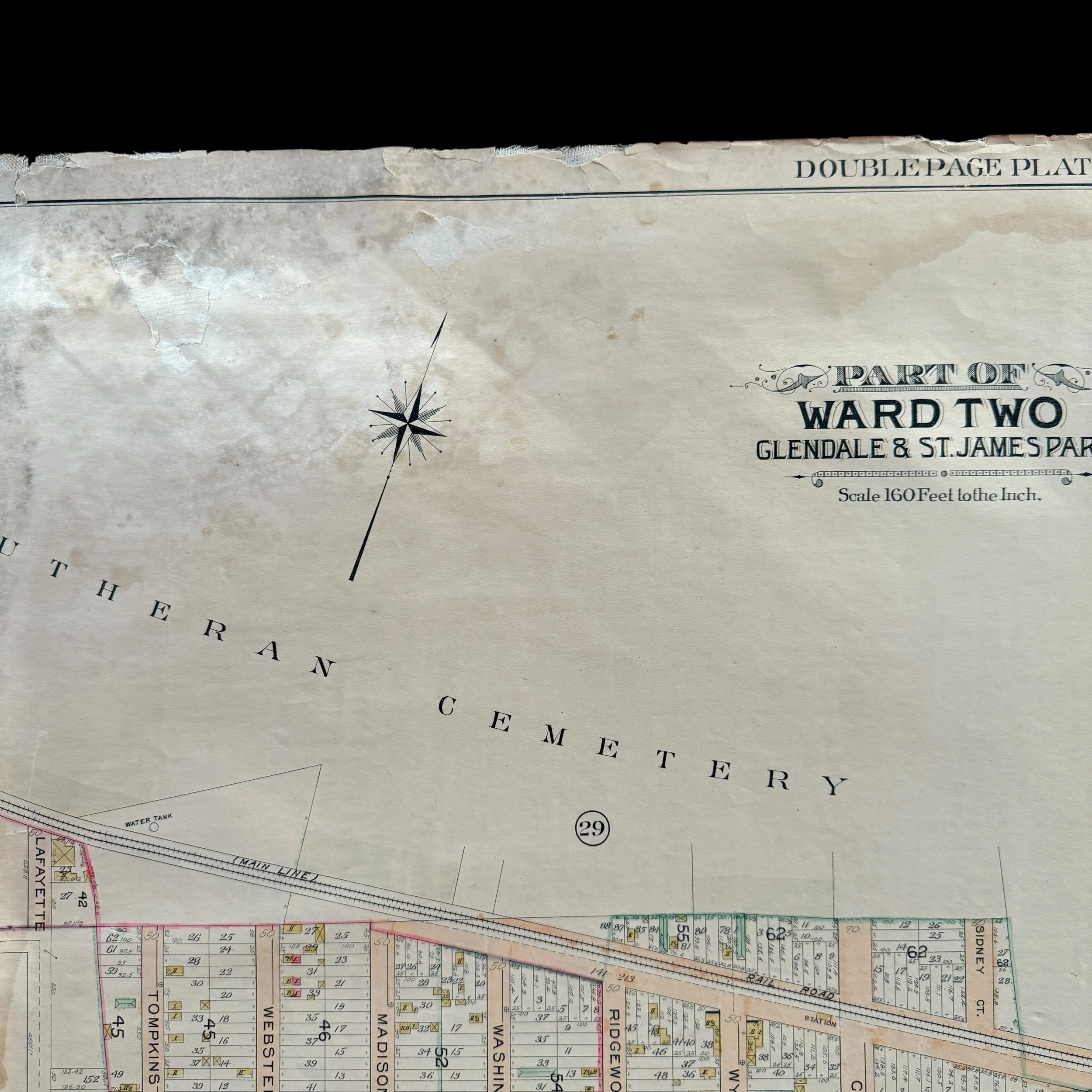
Dated: 1903
Place: New York - Brooklyn - Queens
Publisher: E. Belcher Hyde
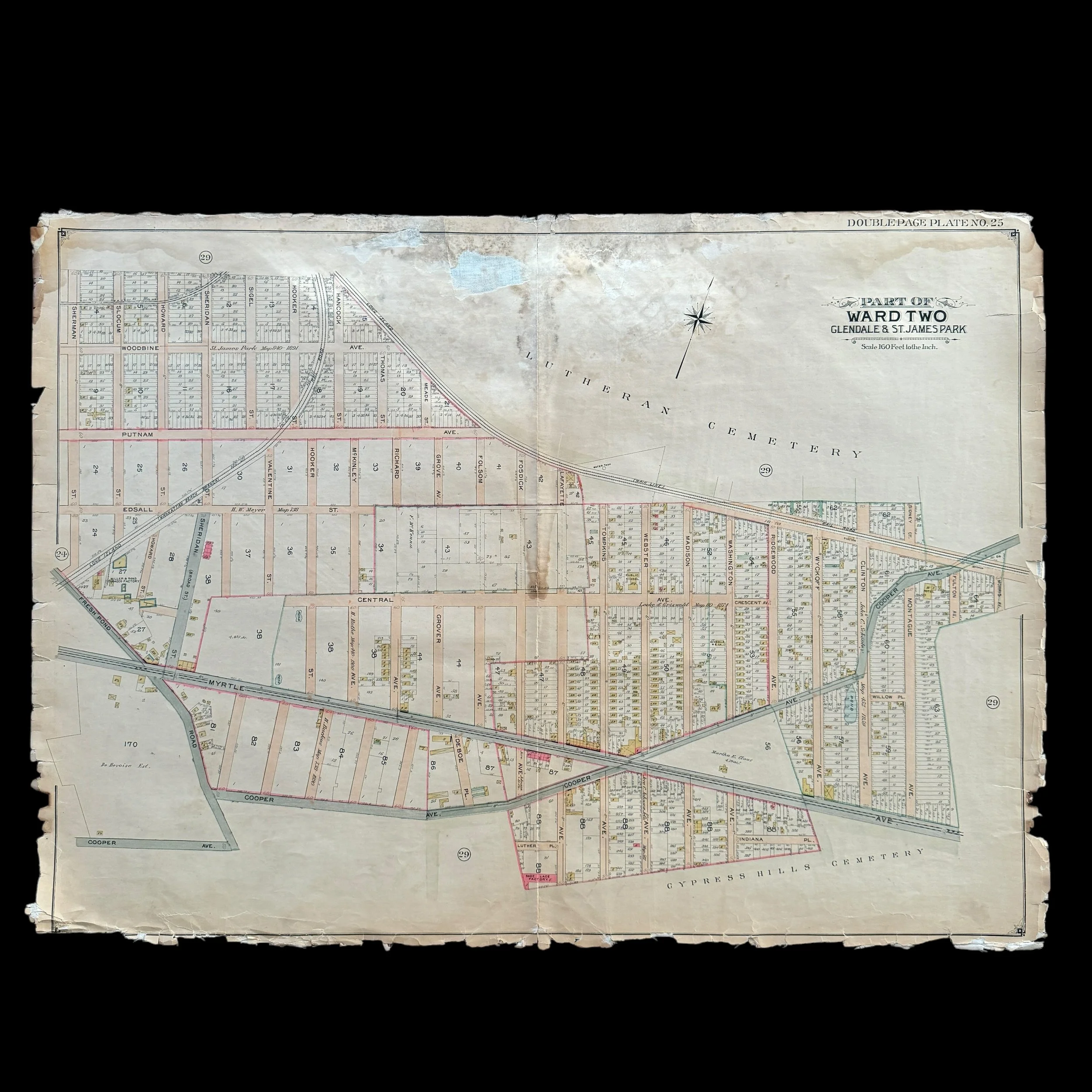
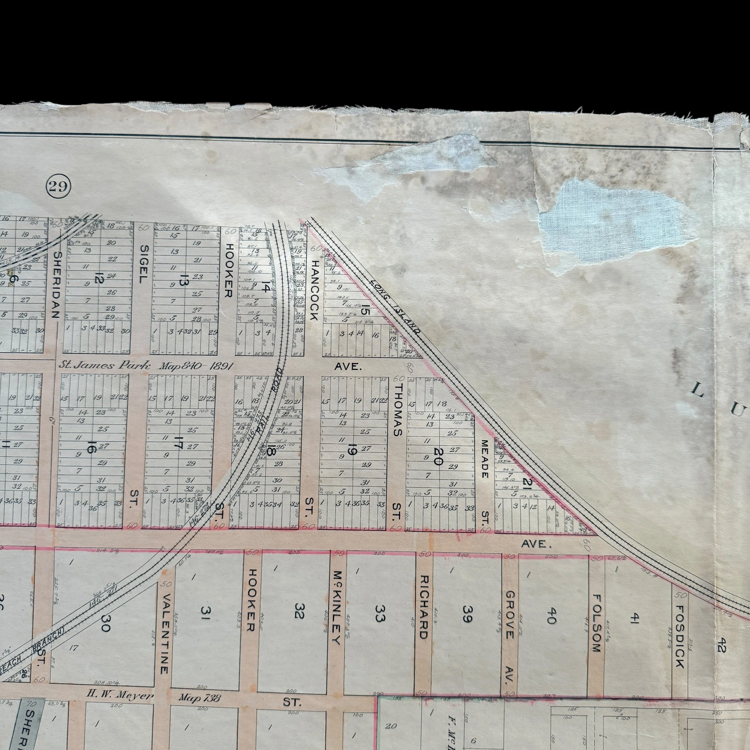
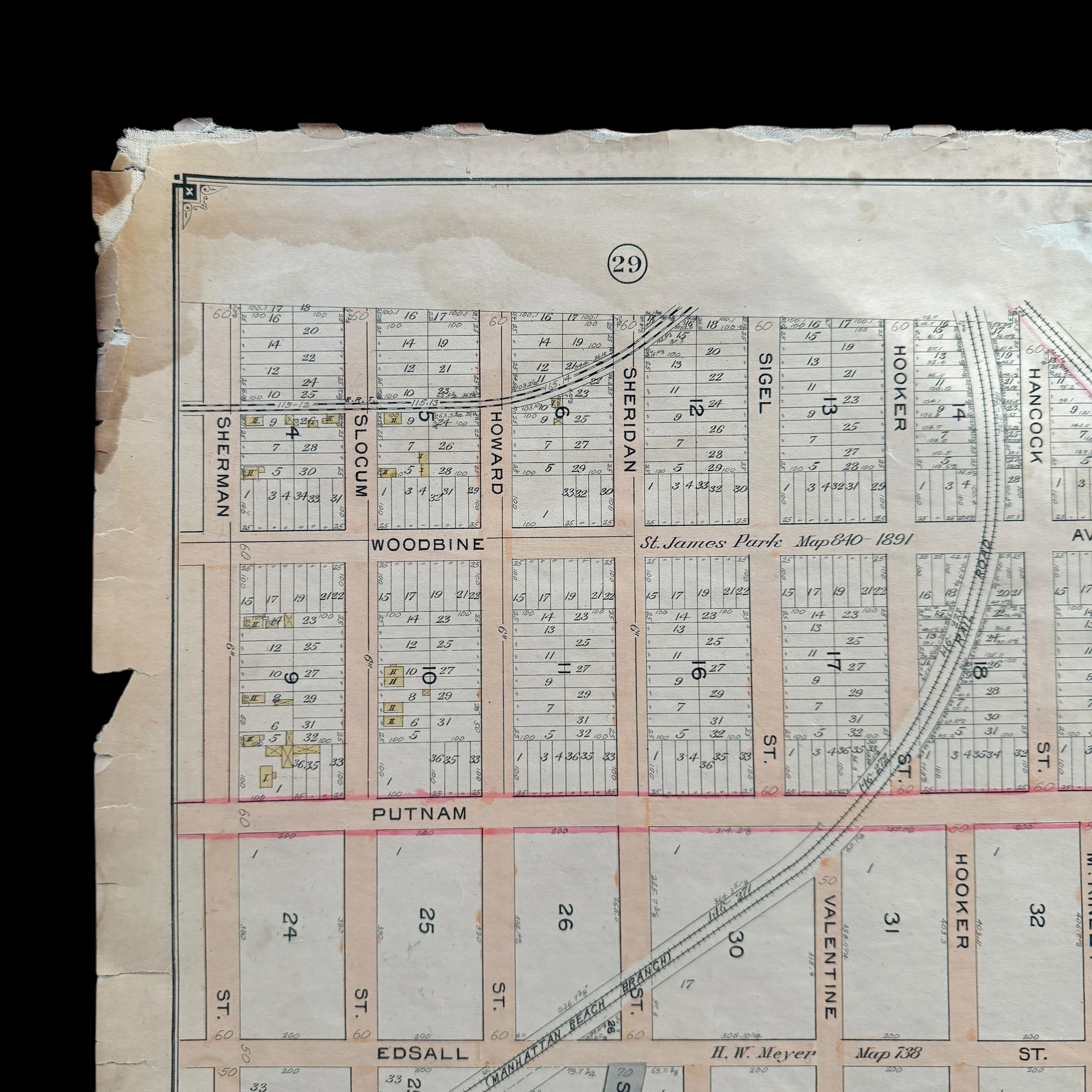
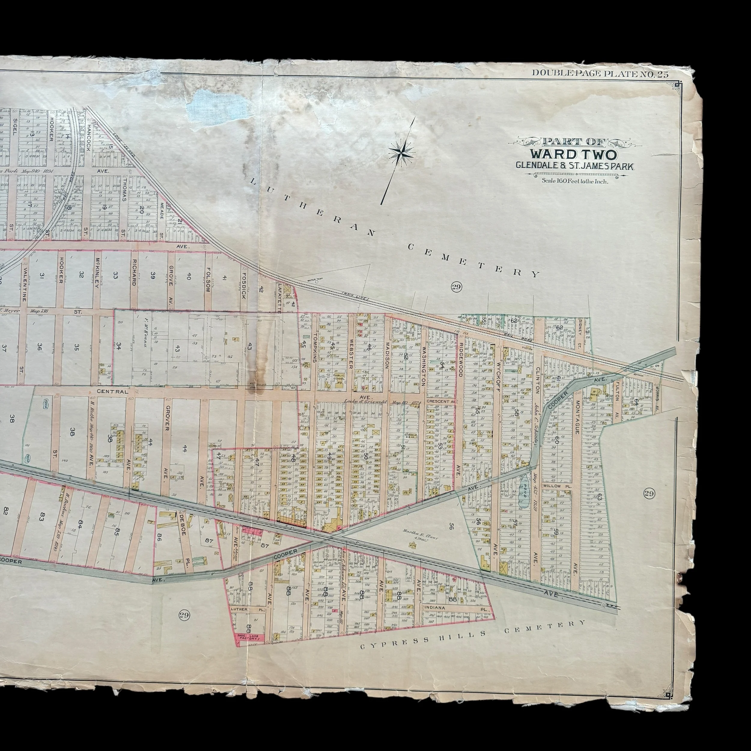
This extremely rare, museum-grade artifact from early 1900s New York City is an original 1903 blueprint map that is a heavily used and marked blueprint was created by the renowned cartographer and publisher E. Belcher Hyde, whose detailed real estate and property maps of New York City and Long Island in the late 19th and early 20th centuries are revered for their precision and historical significance.
At more than 100 years old, this original NYC blueprint is part of a larger series that meticulously documented various sections of New York City, including Queens, Brooklyn, and other boroughs. These maps captured the rapid urban development during a time of major transformation for the city.
In 1903, NYC was at the heart of significant change, having been incorporated into Greater New York City just five years earlier in 1898. The area was transitioning from a largely industrial and residential neighborhood into a more integrated part of the bustling metropolis. Detailed blueprints like this one were vital to guiding that development, serving as indispensable tools for real estate professionals, city planners, and developers.
E. Belcher Hyde's blueprint for NYC offered a wealth of information, from property boundaries and building footprints to street layouts, lot numbers, and ownership details. The blueprint also included railways, waterways, and industrial zones, making it an essential resource for planning new developments and infrastructure. These blueprints were not just practical but legal documents, often used to resolve disputes over property lines and land use.
Hyde’s attention to detail and accuracy in cartography ensured that his blueprints reflected the rapidly changing landscape of New York City at the turn of the century. Today, the 1903 blueprint is a valuable historical artifact, offering a detailed glimpse into the urban planning and development of Long Island City during this pivotal era.
Maps published by E. Belcher Hyde are now considered some of the most important historical documents of the time, providing an unparalleled snapshot of New York City’s growth, land use, and infrastructure at the height of their transformation into a global metropolis.
This is truly a once-in-a-lifetime opportunity to own a one-of-a-kind piece of New York City history. This original 1903 E. Belcher Hyde blueprint is the only known version available for purchase in the public sector. With the majority of these rare blueprints held in private museum collections, opportunities like this are exceedingly rare, making this a unique chance to own an authentic artifact of New York’s early 20th-century development.
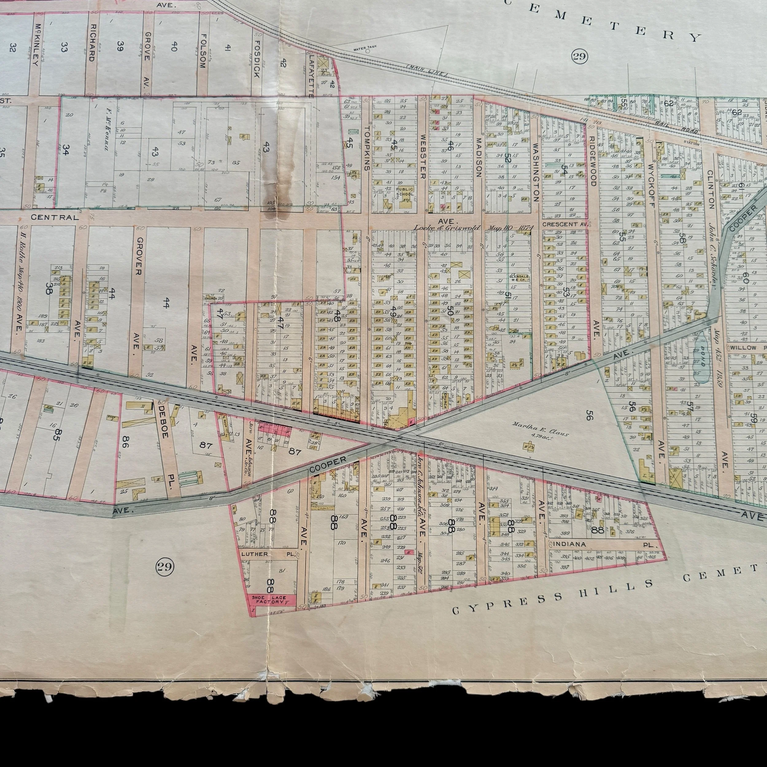
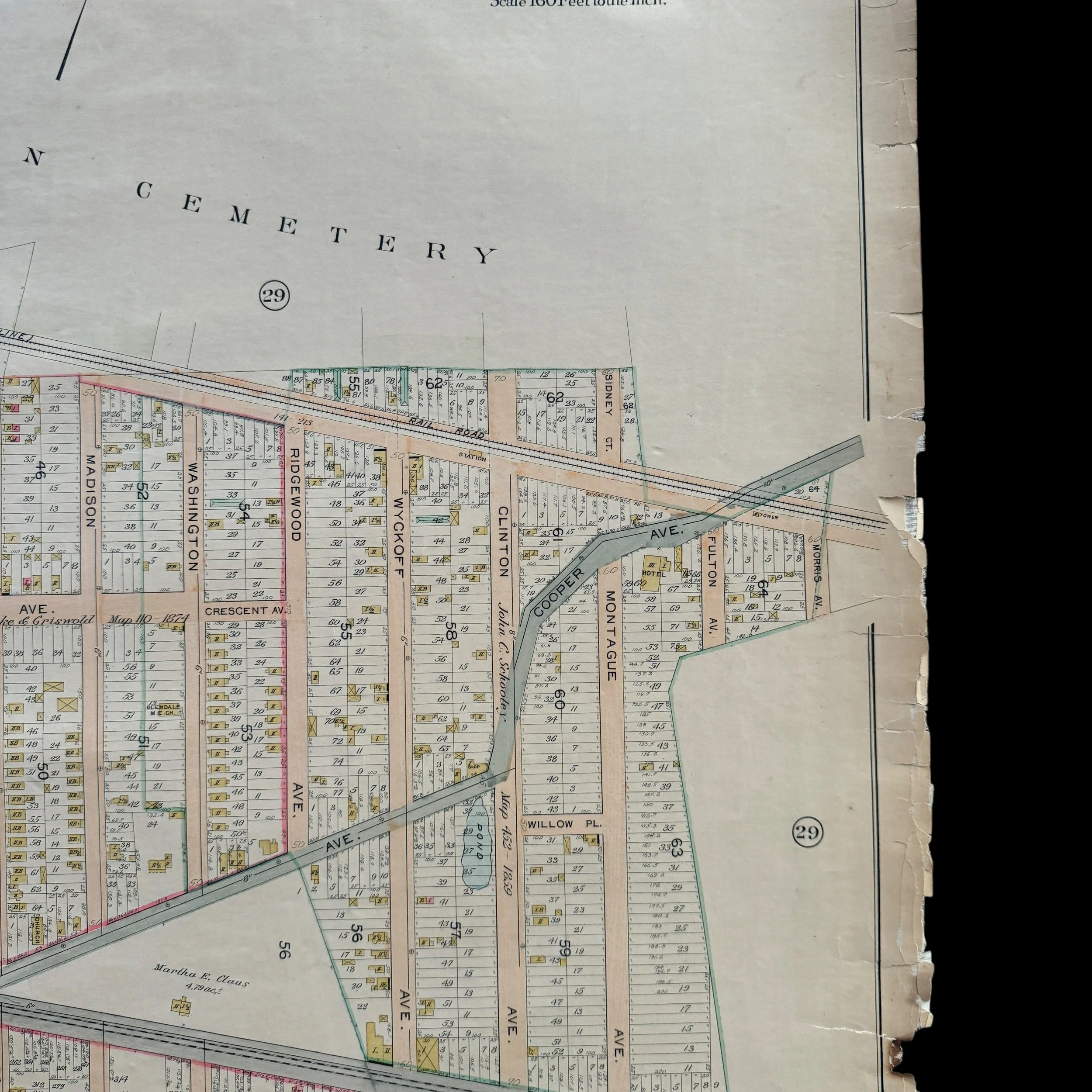
Glendale, Queens, and St. James Park, located in the Bronx, offer unique perspectives on New York City’s evolution in the early 1900s. Glendale, a neighborhood in western Queens, experienced rapid growth during this period as it transitioned from rural farmland to a bustling suburban community. Meanwhile, St. James Park, a public park in the Bronx, became a beloved recreational area for residents of nearby neighborhoods, reflecting the city's emphasis on public green spaces and community life. Together, these areas illustrate New York City’s early 20th-century transformation, spurred by suburban expansion, the rise of recreational spaces, and the influx of diverse immigrant communities.
Glendale: From Farmland to Suburban Neighborhood
Glendale was originally settled in the mid-19th century, largely as an agricultural community. Named after the scenic valleys of Scotland, Glendale remained predominantly rural into the late 1800s, with fields, farms, and small settlements defining its landscape. This began to change in the early 1900s, as New York City’s population boom led to increased demand for suburban housing. Glendale’s location, close enough to Manhattan to accommodate commuting but far enough to offer space and affordability, made it an attractive choice for new residents seeking suburban-style living.
The extension of transportation networks was crucial in Glendale’s transformation. The Long Island Rail Road (LIRR) provided a direct link to Manhattan, while trolley lines made the area easily accessible to other parts of Queens and Brooklyn. By the early 1900s, these connections led to the development of new housing tracts and the arrival of working- and middle-class families. Real estate developers marketed Glendale as a suburban retreat, ideal for families who desired proximity to the city but wanted a quieter, more spacious environment.
Industrialization and Community Life in Glendale
Though Glendale was increasingly suburban in the early 20th century, it also experienced industrial growth, which influenced its character and economy. Factories and warehouses began to spring up along its borders, including major employers like the Atlas Terminal, which became one of the largest industrial complexes in Queens. Factories in Glendale produced various goods, from glass and textiles to foods and chemicals, creating job opportunities that attracted residents from diverse backgrounds.
Immigrant communities, particularly German, Italian, and Eastern European families, became a significant part of Glendale’s population during this period. These immigrants brought with them a rich cultural heritage, establishing churches, social clubs, and local businesses that reflected their traditions. St. Pancras Church, founded by German immigrants, became a cultural and social center in Glendale, providing not only religious services but also social events and community support. Local bakeries, delis, and butchers also catered to the diverse cultural backgrounds of Glendale's residents, making the neighborhood a lively mix of cultural influences.
Community life in Glendale flourished in the early 1900s, with schools, parks, and social organizations fostering a strong sense of neighborhood identity. As the population grew, the need for public services and infrastructure led to the establishment of schools, libraries, and recreational facilities. Schools like PS 91 provided education for local children, while parks and community centers offered places for residents to gather, socialize, and relax. Glendale’s identity as a close-knit, family-oriented neighborhood began to solidify during this period, a legacy that remains evident in the area today.
St. James Park: A Public Green Space in the Bronx
In contrast to Glendale's suburban development, St. James Park in the Bronx serves as an example of New York City’s commitment to creating public recreational spaces. Established in the late 19th century, St. James Park became a cherished public park in the early 1900s, serving the needs of Bronx residents in the surrounding neighborhoods of Fordham, Kingsbridge, and Bedford Park. The park was named after St. James Episcopal Church, a historic congregation founded nearby in the 1800s. Initially a modest green space, the park was expanded and improved over time to accommodate a growing urban population in the Bronx.
In the early 20th century, St. James Park reflected the broader City Beautiful movement, which emphasized the importance of public parks and green spaces in urban areas. City planners and reformers believed that parks could improve the quality of life, provide a refuge from the hustle and bustle of urban life, and promote public health. St. James Park’s design included open lawns, walking paths, and shaded areas, making it a welcoming space for relaxation and recreation. It was one of several parks established in the Bronx, which was undergoing rapid population growth and urban development.
Recreation and Community Events in St. James Park
As New York City's population increased, public parks like St. James became important community hubs, especially for the working-class and immigrant residents of the Bronx who had limited access to private leisure spaces. St. James Park offered a range of recreational facilities and became a popular spot for family outings, picnics, and social gatherings. The park’s lawns and open spaces provided room for sports, informal games, and community events, while walking paths allowed residents to enjoy a peaceful escape from city life.
In the early 1900s, St. James Park also became a venue for cultural events and public celebrations. Festivals, concerts, and holiday gatherings drew large crowds, reflecting the park’s role as a gathering place for the diverse communities of the Bronx. The park’s facilities evolved over time to meet the needs of residents, with playgrounds, sports courts, and picnic areas added to enhance its recreational offerings. St. James Park was, and remains, a vital green space that fosters community connections and serves as a symbol of the city's dedication to public recreational facilities.
Transportation and Urban Development in the Bronx
The Bronx, like Queens, was experiencing rapid development in the early 1900s, largely due to advancements in transportation. The extension of subway lines, particularly the 3rd Avenue Elevated Railway, made the Bronx more accessible from Manhattan, drawing residents to neighborhoods around St. James Park. The expansion of subway and trolley lines enabled commuting, facilitating the Bronx’s transformation from a relatively rural area into a bustling urban center.
With improved transportation, the Bronx attracted a diverse population of new residents, including Irish, Italian, and Eastern European immigrants. These communities settled near St. James Park and nearby neighborhoods, contributing to the area’s vibrant cultural landscape. The proximity of St. James Park allowed residents to enjoy a green space amid the urban expansion, providing a quality-of-life benefit that became increasingly important as the borough grew.
Legacy of Early 20th Century Development
The early 1900s left an enduring legacy in both Glendale and St. James Park. Glendale’s suburban growth, combined with its industrial presence, established it as a unique neighborhood that balanced residential life with economic activity. The immigrant communities that settled in Glendale laid the foundations for a close-knit neighborhood identity that remains today, while the area's blend of industrial and suburban characteristics shaped its urban fabric.
St. James Park, meanwhile, became a symbol of the Bronx’s transformation and New York City’s commitment to public parks. As the Bronx urbanized, the park provided residents with a vital green space for recreation and community events. It remains a beloved park, reflecting the city’s early dedication to creating public spaces that serve the community's needs.
The early 1900s were transformative for both Glendale, Queens, and St. James Park in the Bronx, each reflecting unique aspects of New York City’s growth. Glendale’s evolution from farmland to suburban neighborhood, supported by industrialization and immigrant communities, made it a distinctive part of Queens with a lasting family-oriented character. St. James Park, on the other hand, exemplified the city’s vision for public green spaces, providing Bronx residents with a refuge and social center as their neighborhoods expanded. Together, Glendale and St. James Park highlight New York City’s efforts to balance residential, industrial, and recreational spaces during a period of rapid change, preserving community well-being amid urban growth.