VERY RARE! Original 1903 New York City Long Island Brooklyn Queens Early 1900's NYC Blueprint Map (PLATE 10)
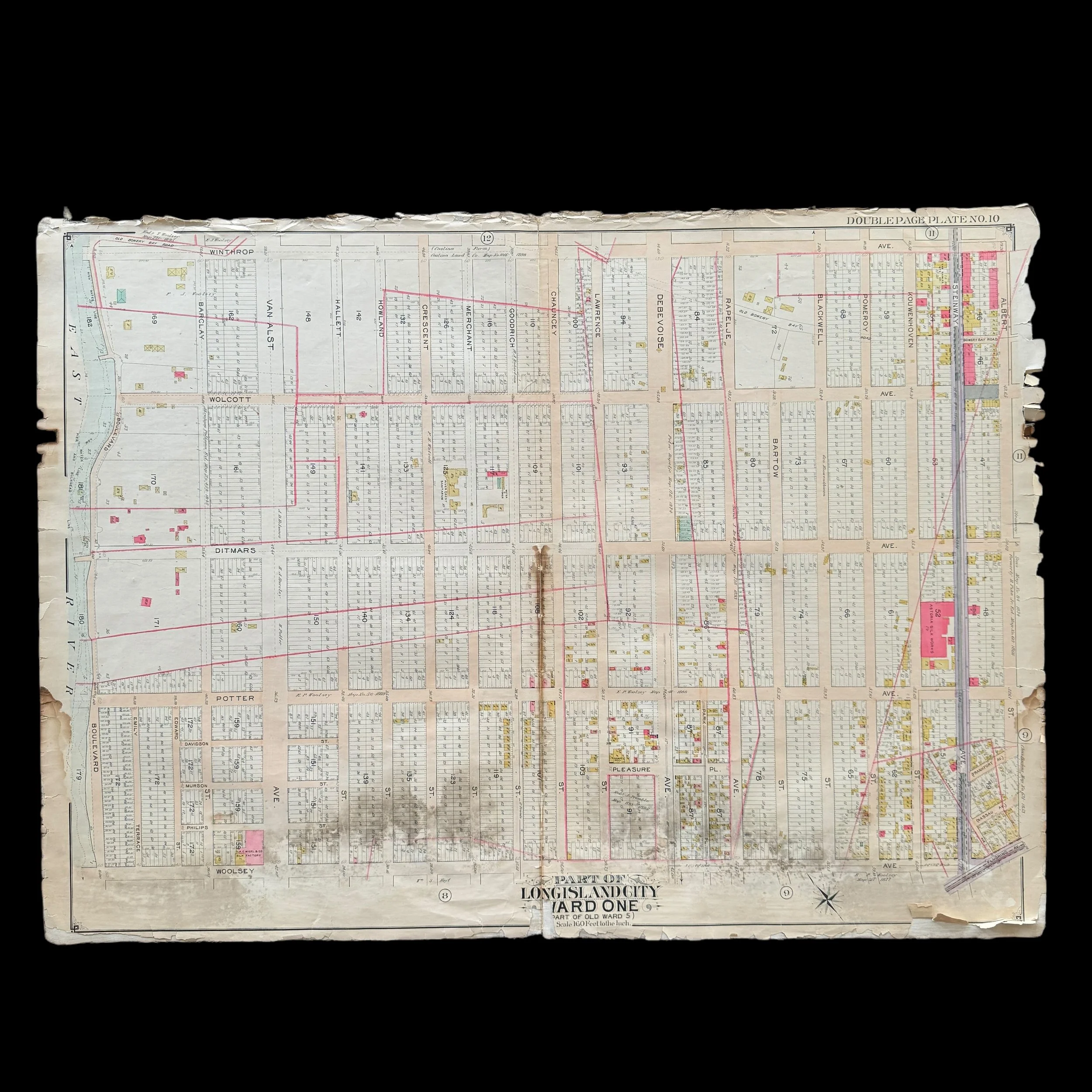

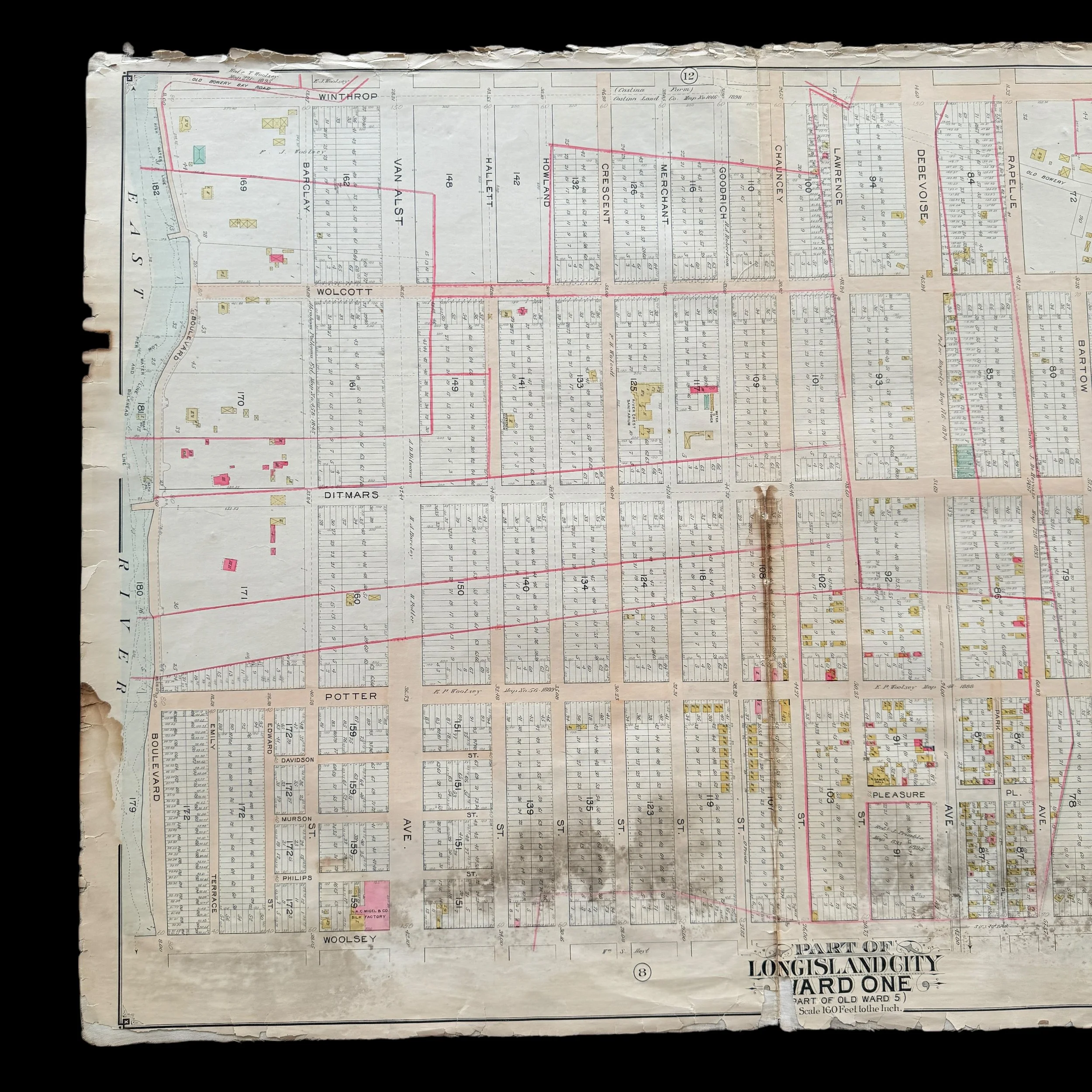
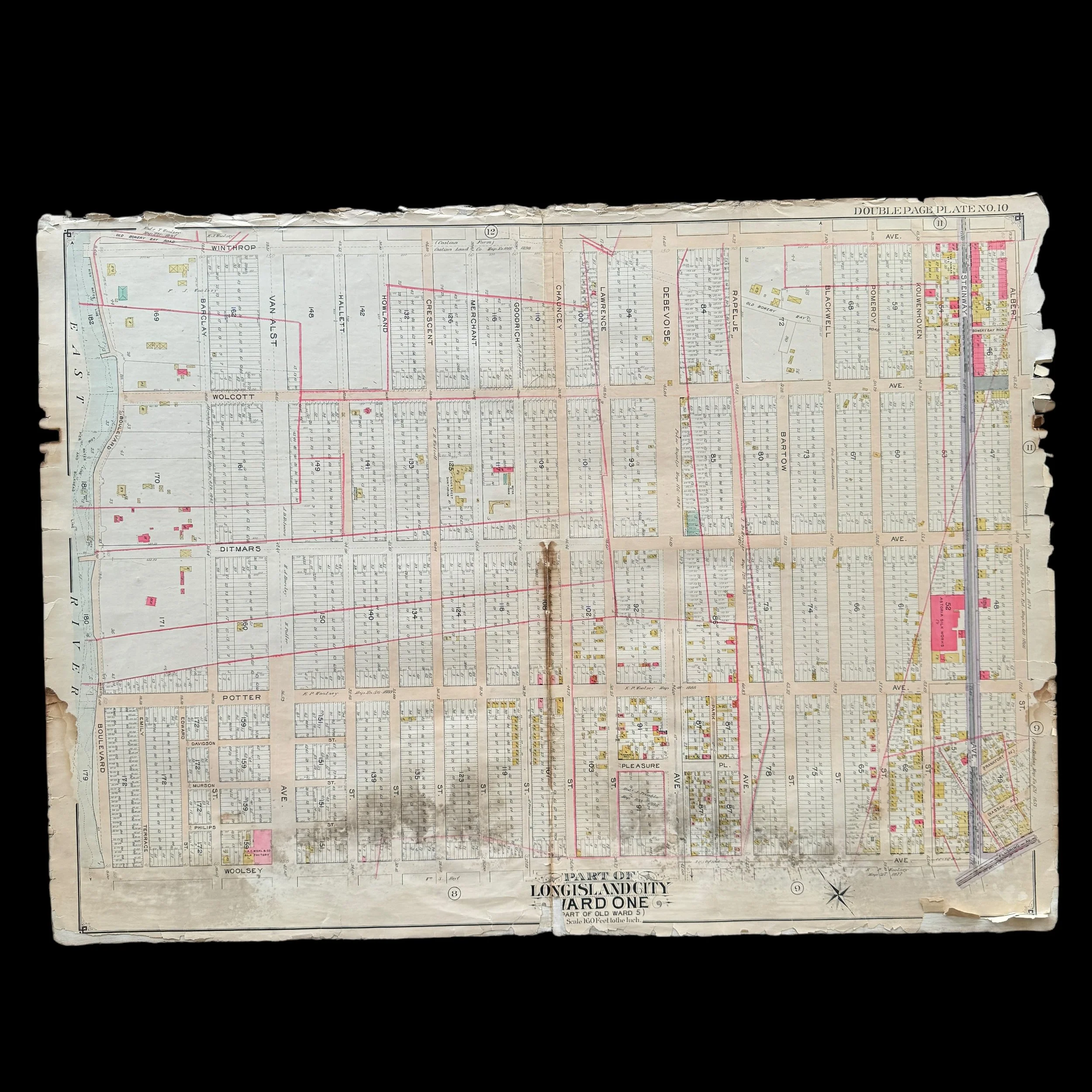


VERY RARE! Original 1903 New York City Long Island Brooklyn Queens Early 1900's NYC Blueprint Map (PLATE 10)
Comes with a hand-signed C.O.A.
*This is an extremely rare piece of original early 1900s New York City history that would make a stunning centerpiece in any collection. Framed and displayed, this original 1903 NYC blueprint would not only serve as a captivating conversation piece but also as a tangible link to the city’s past. Its detailed craftsmanship and historical significance make it perfect for anyone passionate about New York City's rich architectural and urban development history. Whether featured in a private collection, office, or historical space, this rare blueprint is sure to become a treasured heirloom that celebrates the evolution of one of the world's greatest cities.
Size: 27 × 37 inches
Dated: 1903
Place: New York - Brooklyn - Queens
Publisher: E. Belcher Hyde
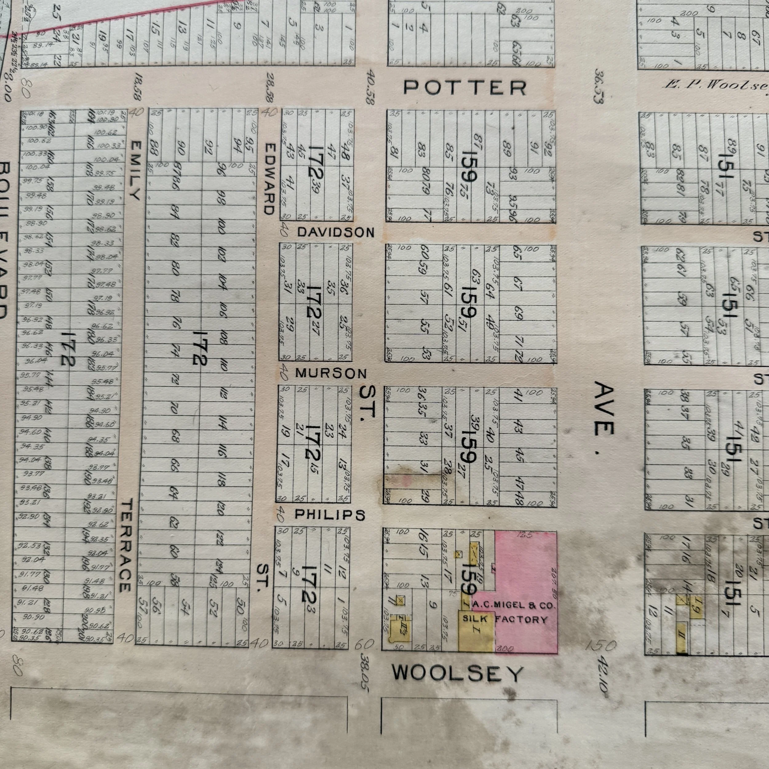
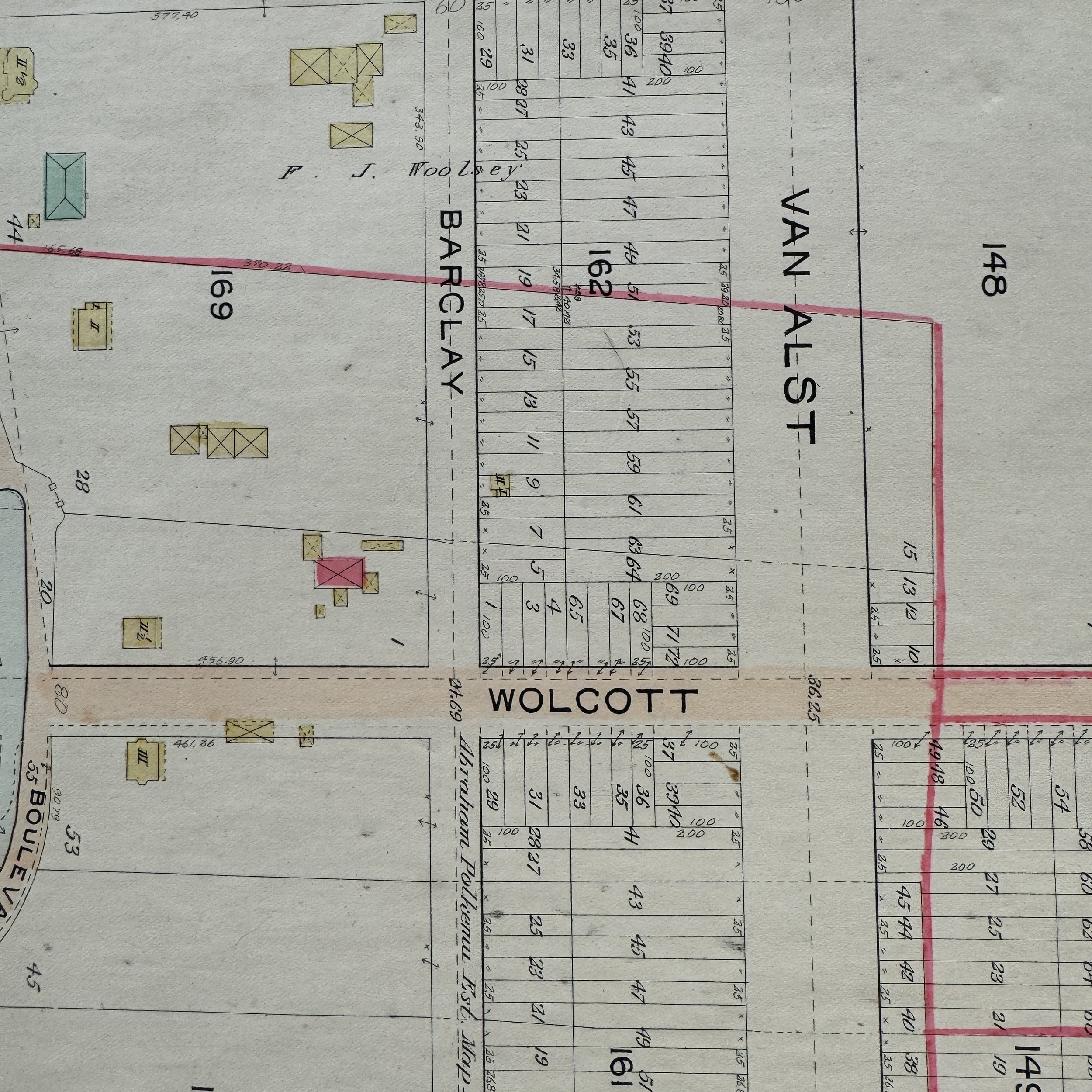
Features: Winthrop Ave., Albert St., Flushing Ave.; Including Woolsey Ave., Boulevard
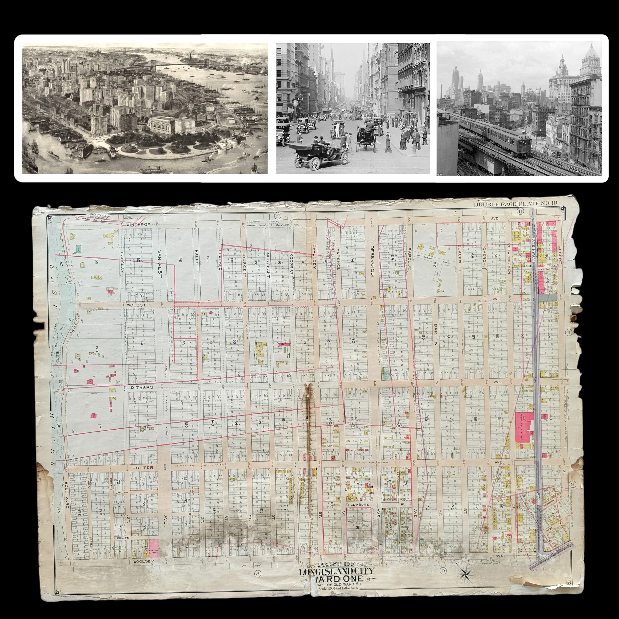
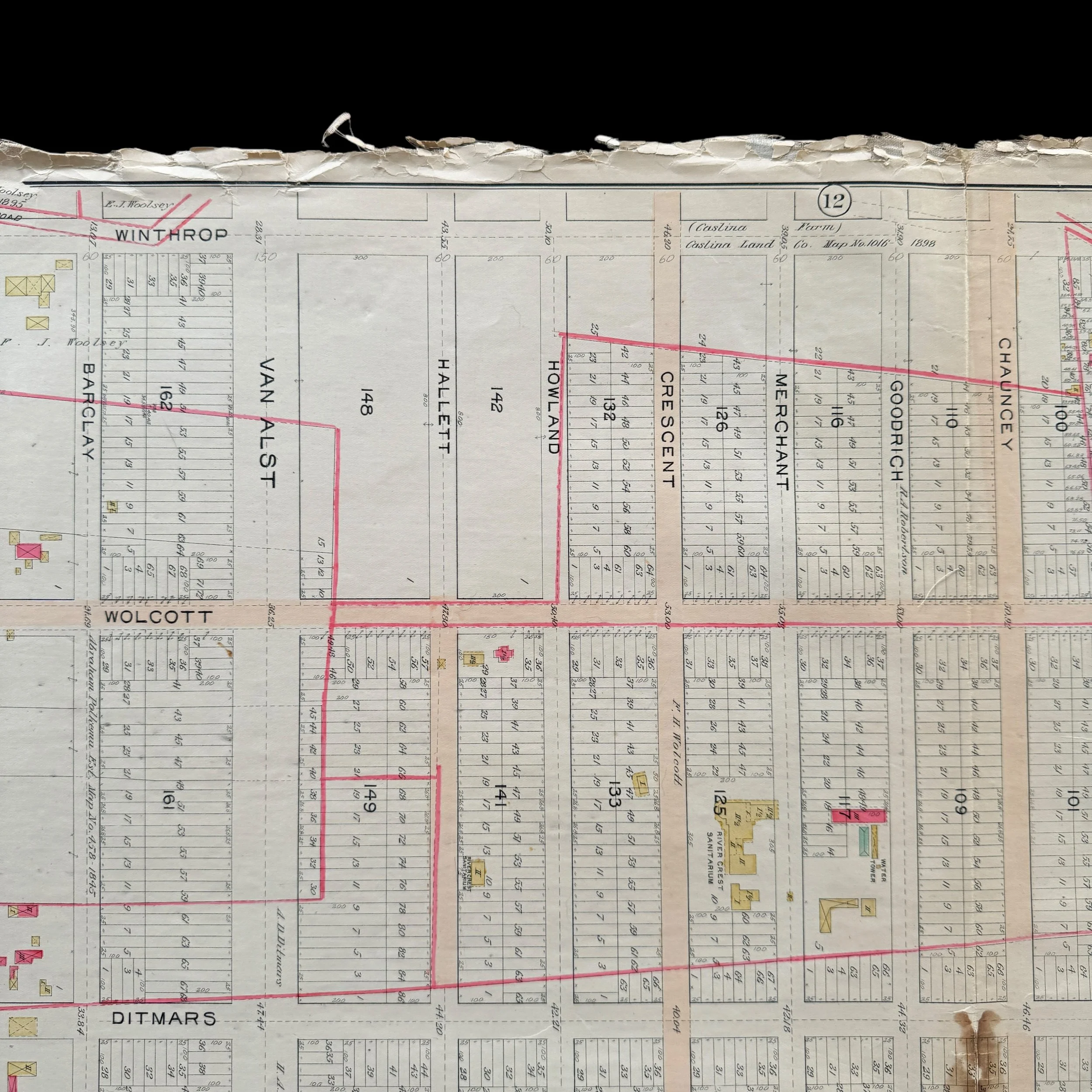
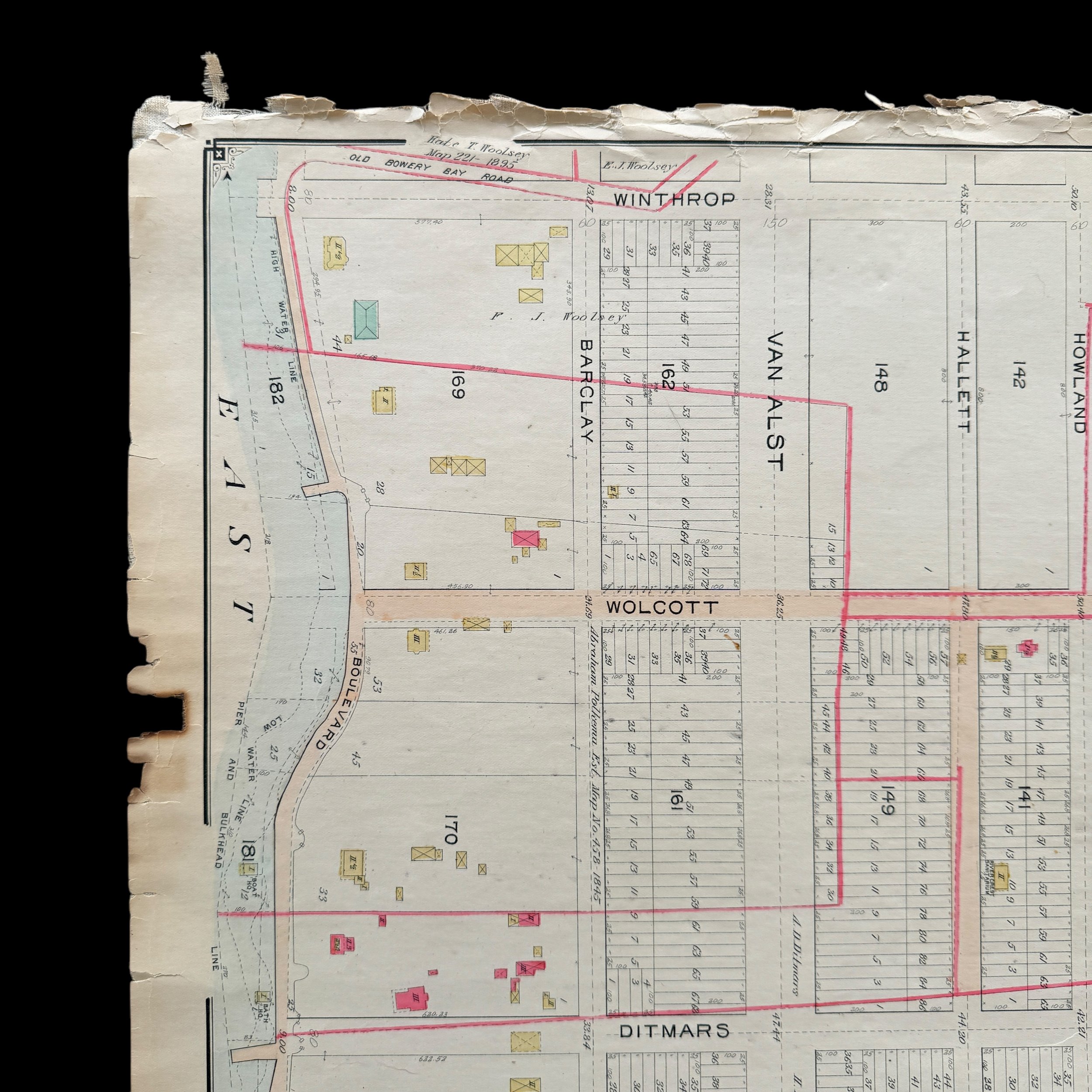
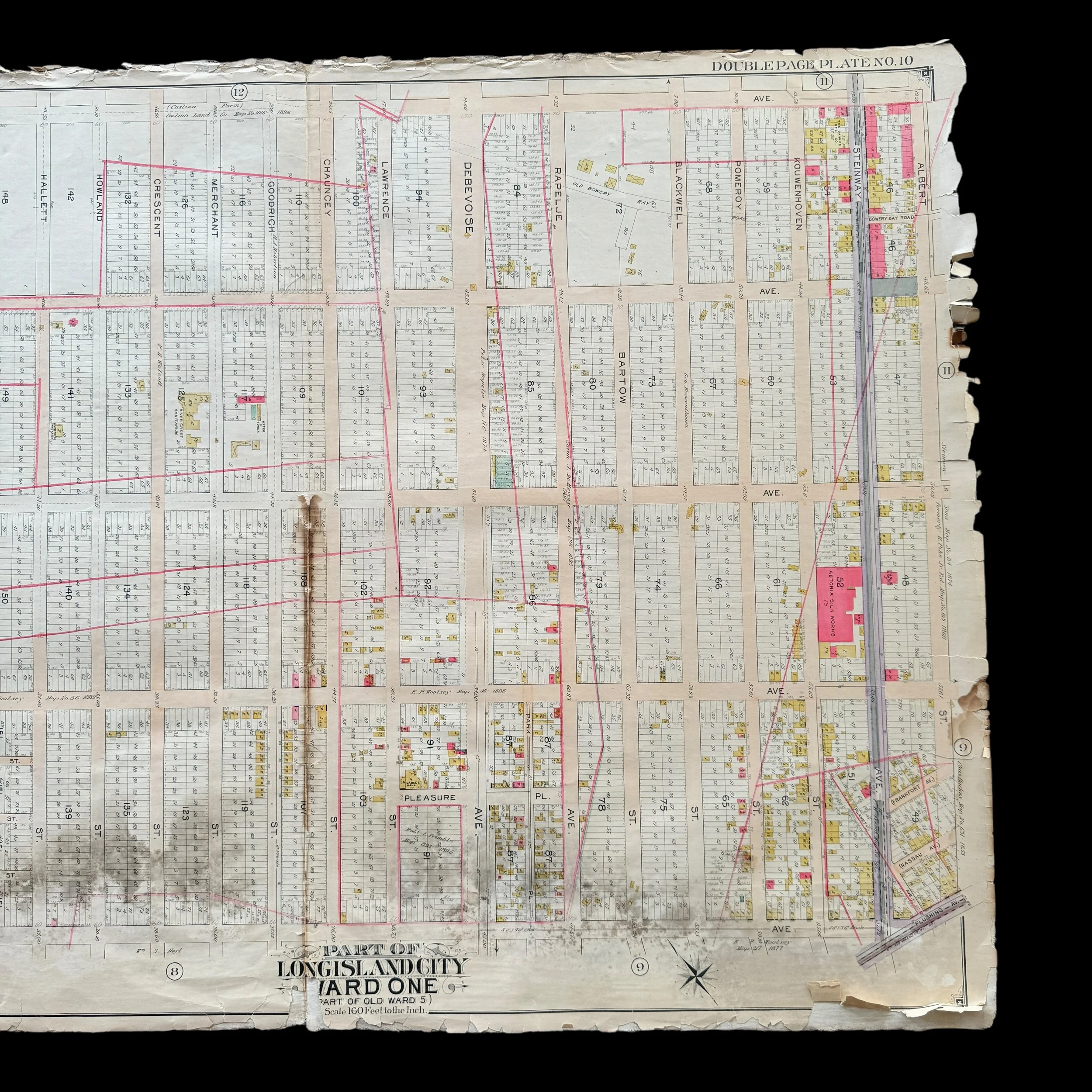
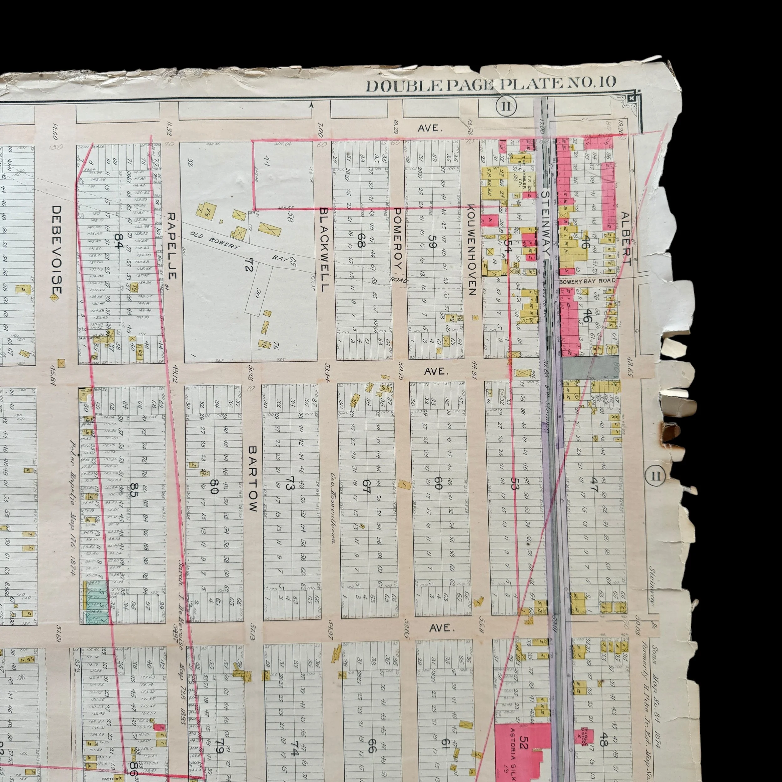
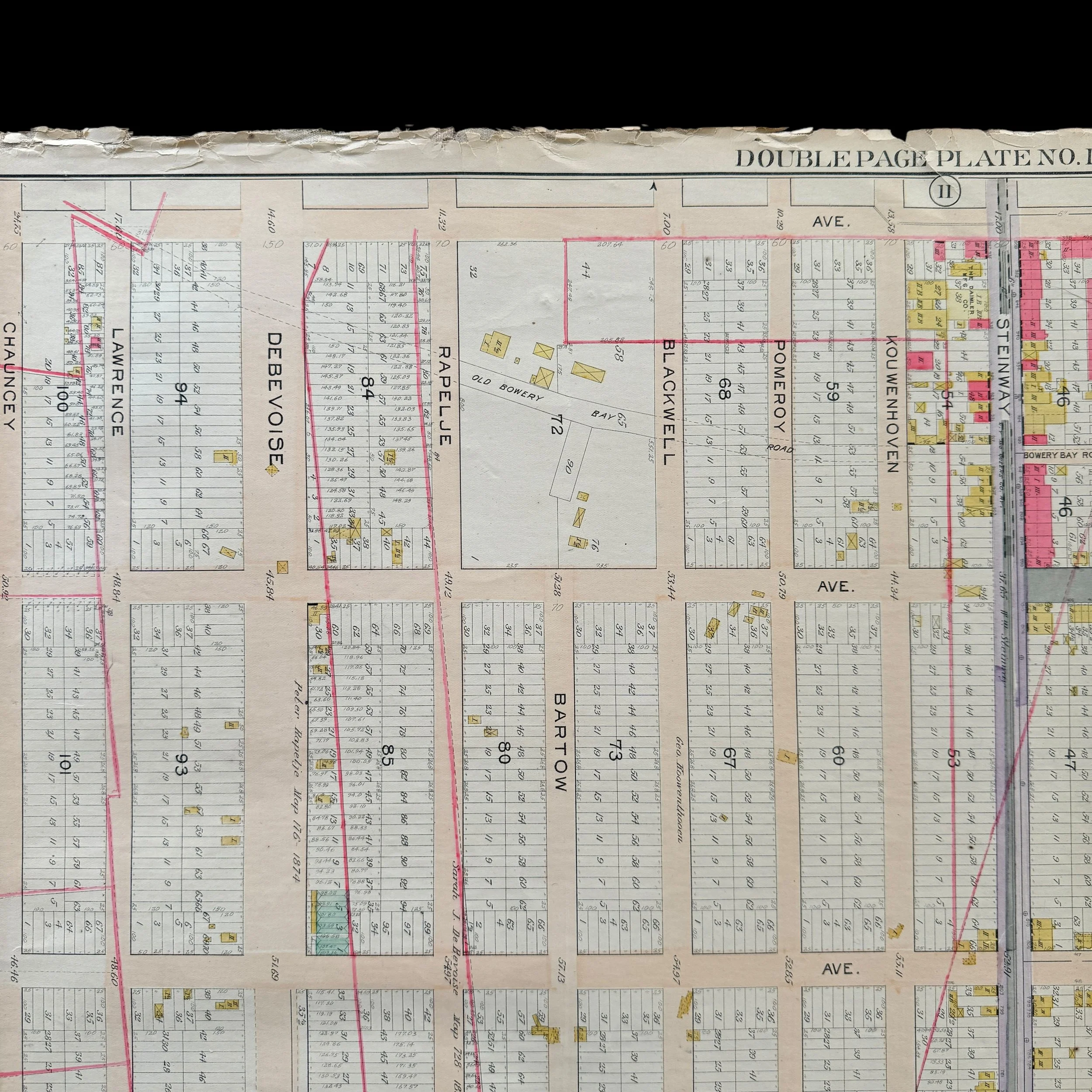
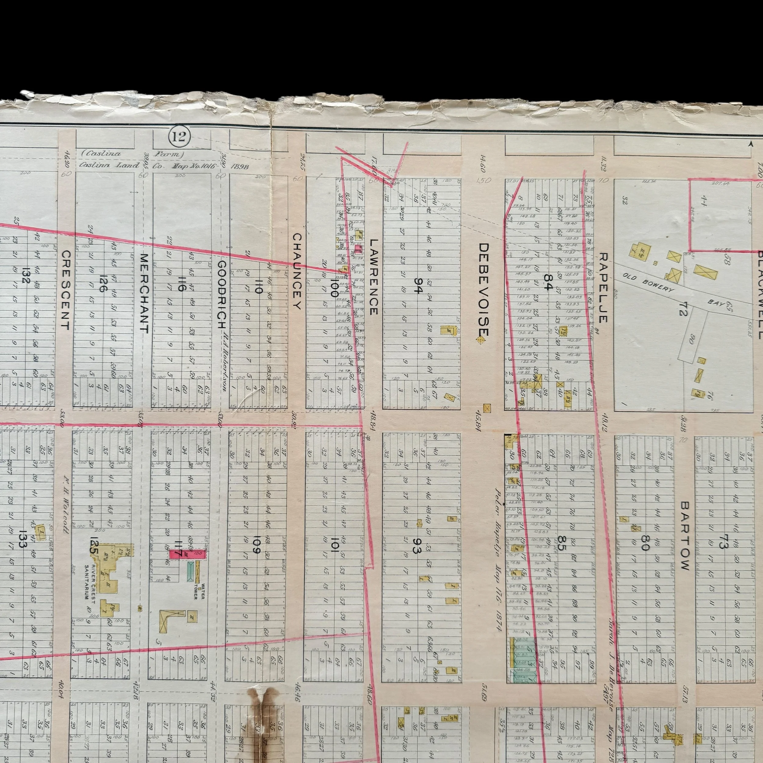
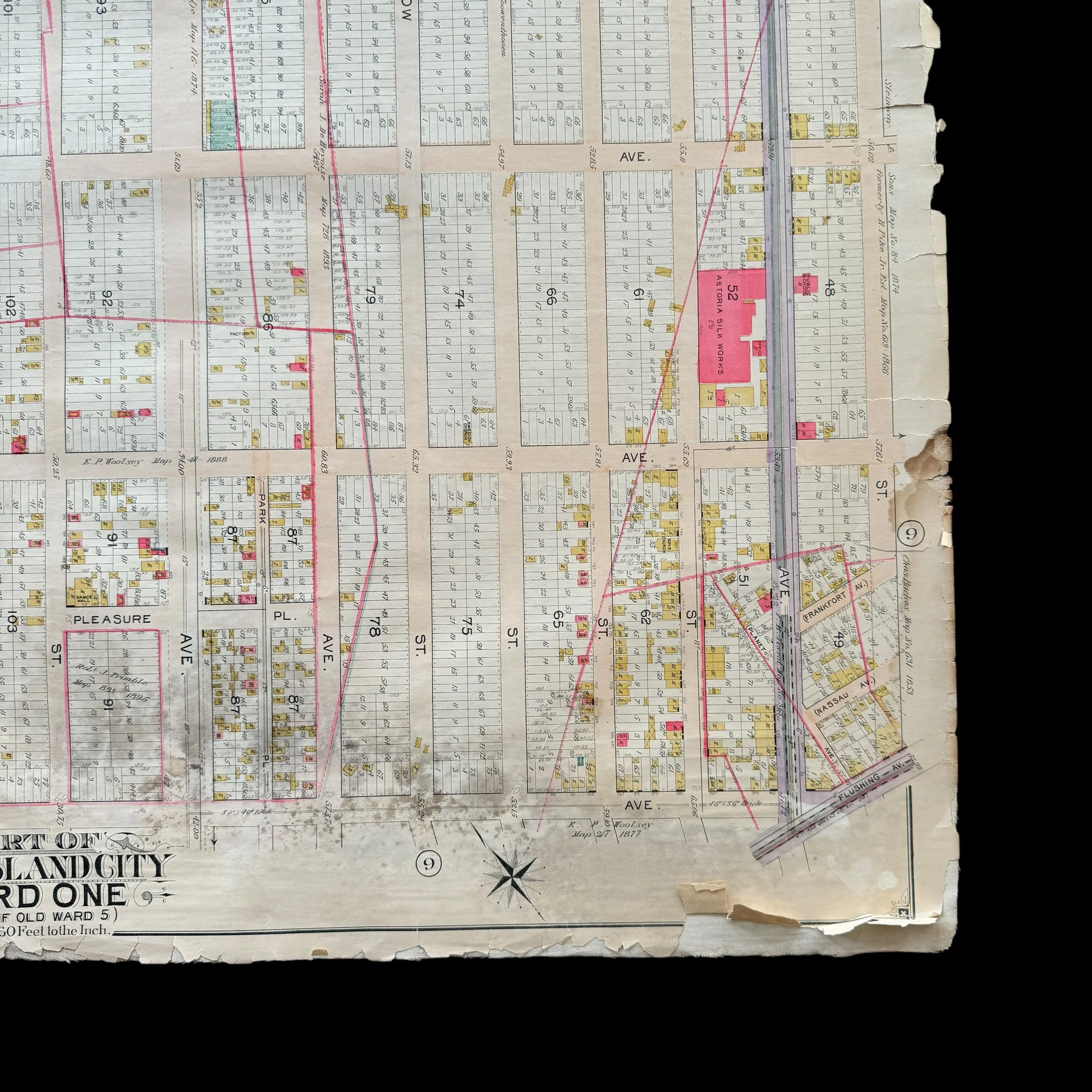
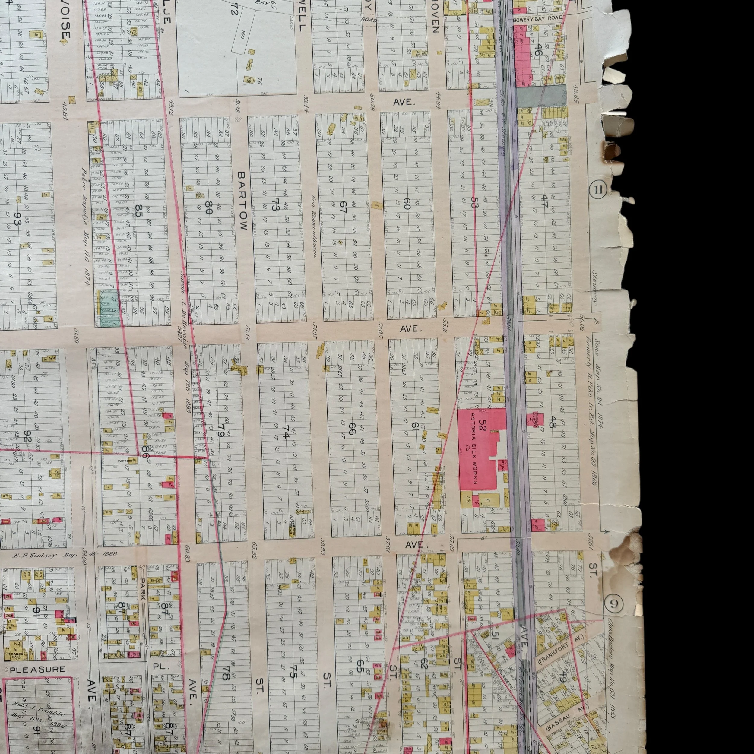
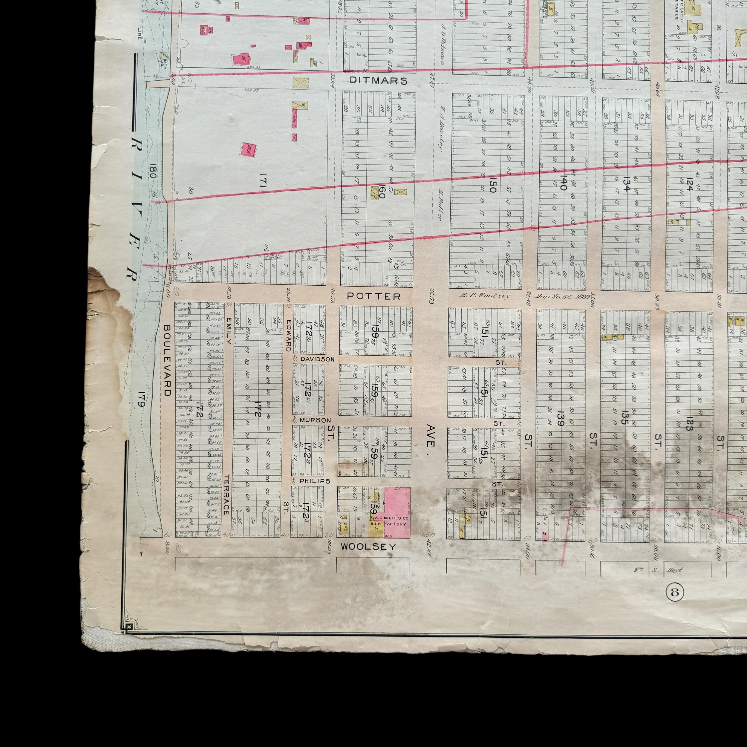
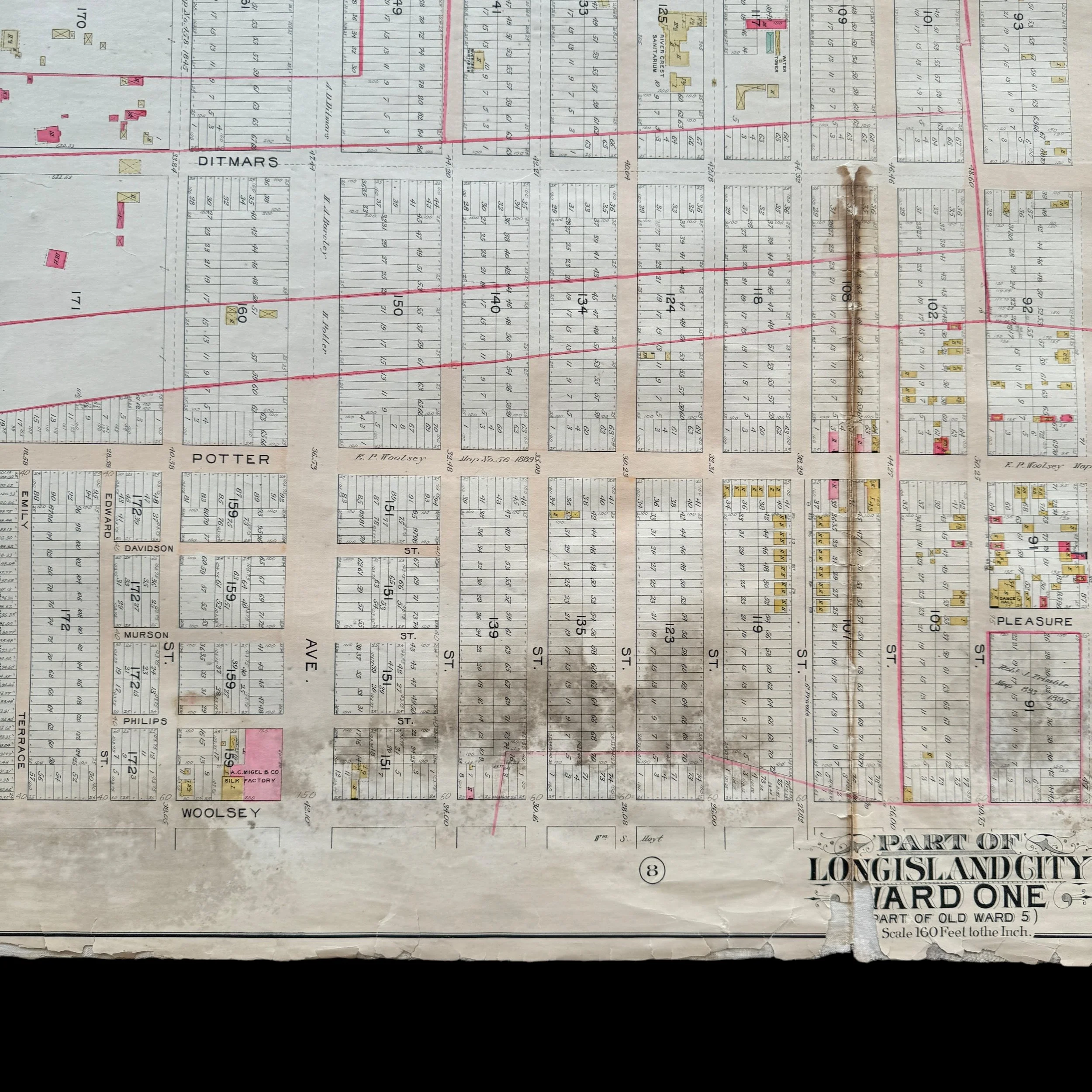
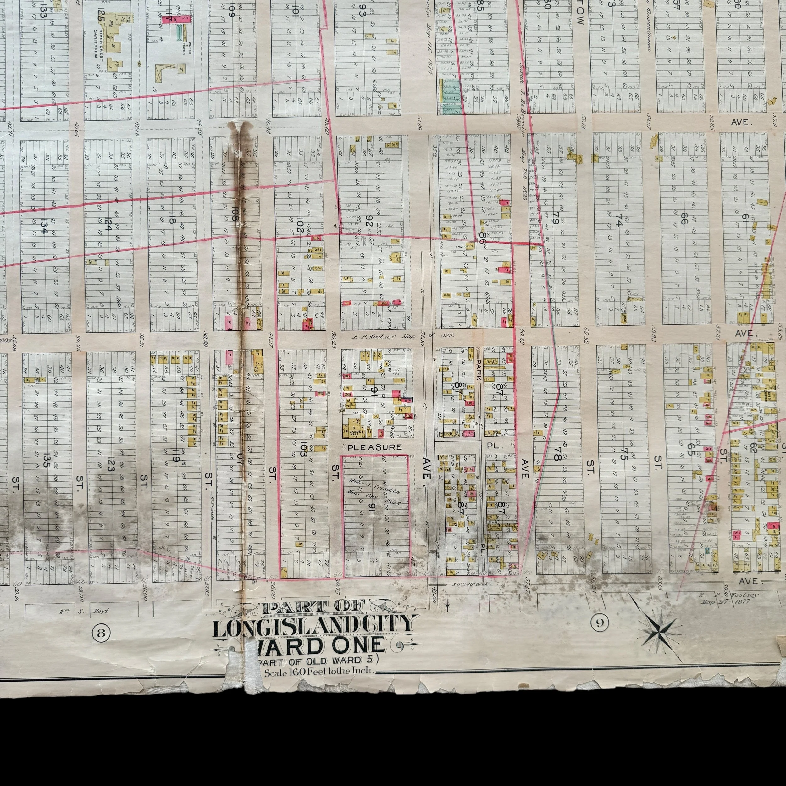
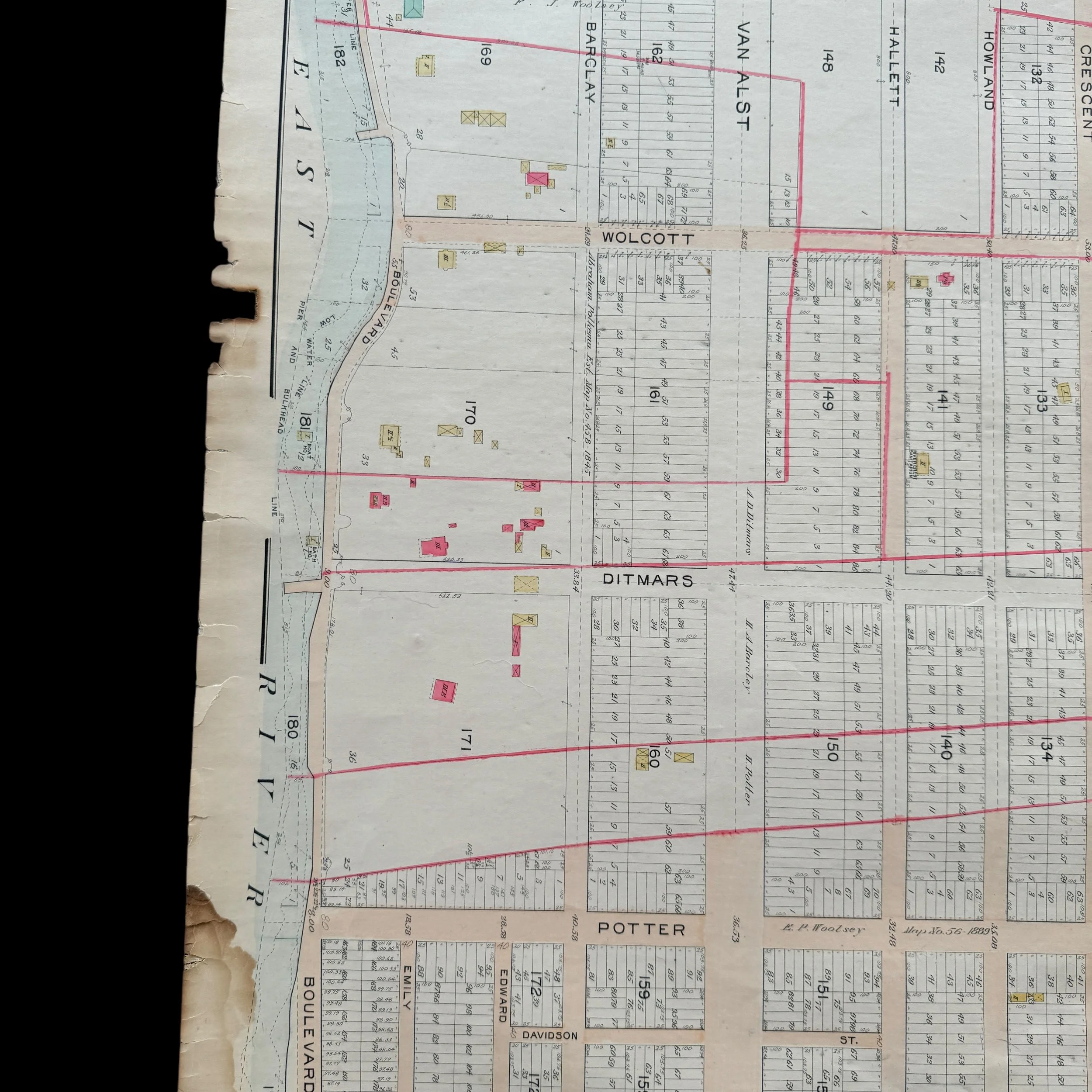
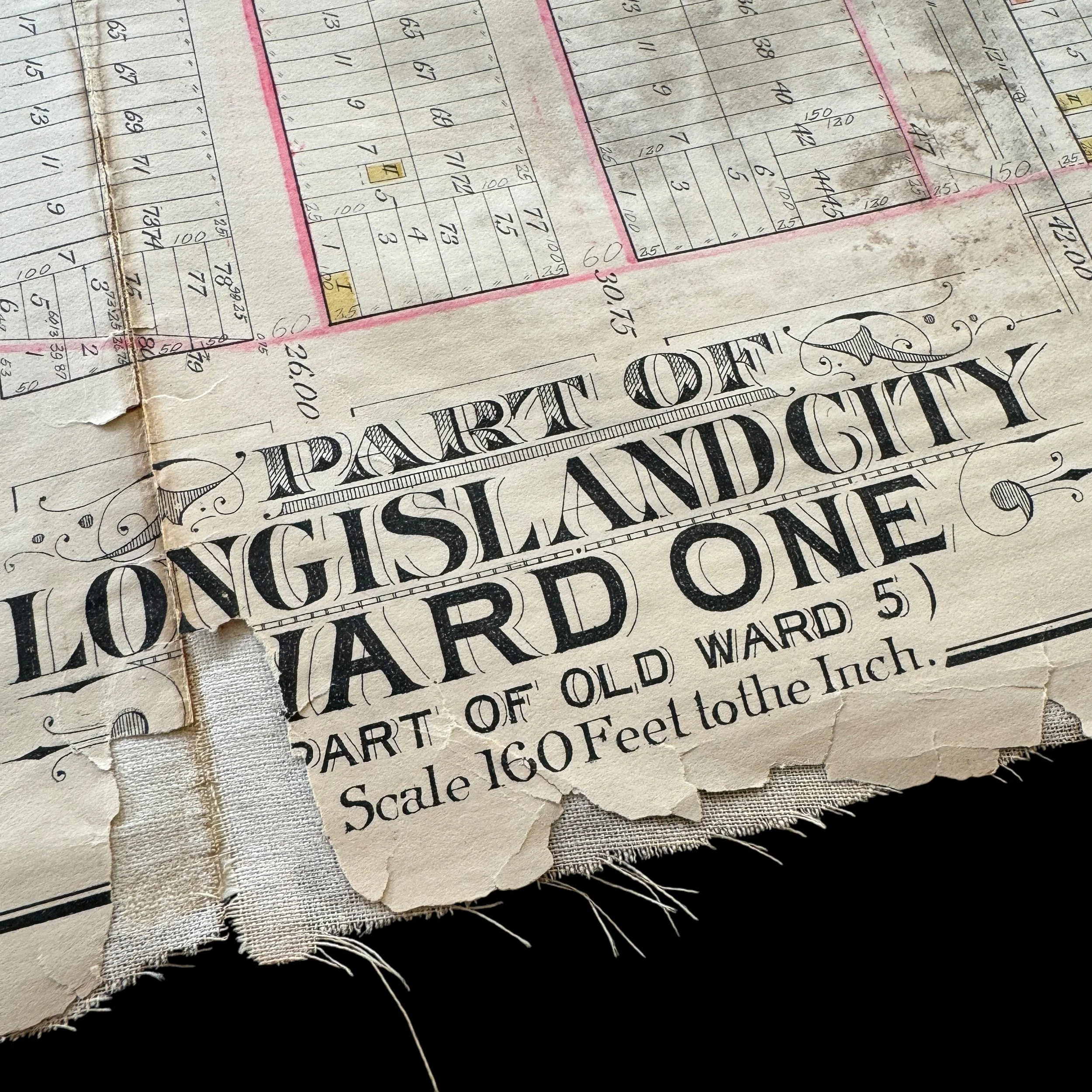
This extremely rare, museum-grade artifact from early 1900s New York City is an original 1903 blueprint titled “Part of Long Island City - Ward One.” A historic gem, this heavily used and marked blueprint was created by the renowned cartographer and publisher E. Belcher Hyde, whose detailed real estate and property maps of New York City and Long Island in the late 19th and early 20th centuries are revered for their precision and historical significance.
At more than 100 years old, this original NYC blueprint is part of a larger series that meticulously documented various sections of New York City, including Queens, Brooklyn, and other boroughs. These maps captured the rapid urban development during a time of major transformation for the city.
In 1903, Long Island City was at the heart of significant change, having been incorporated into Greater New York City just five years earlier in 1898. The area was transitioning from a largely industrial and residential neighborhood into a more integrated part of the bustling metropolis. Detailed blueprints like this one were vital to guiding that development, serving as indispensable tools for real estate professionals, city planners, and developers.
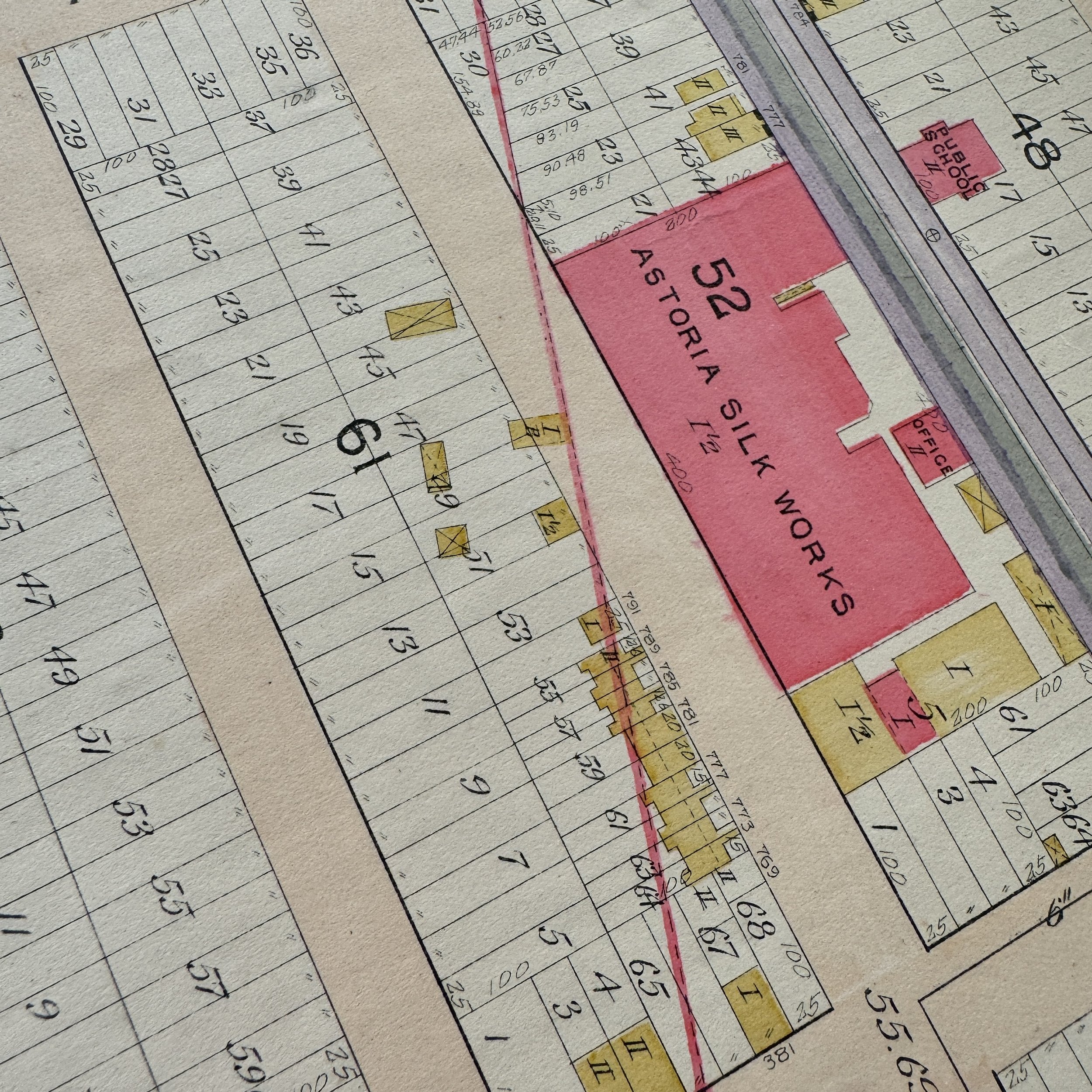
E. Belcher Hyde's blueprint for Long Island City - Ward One offered a wealth of information, from property boundaries and building footprints to street layouts, lot numbers, and ownership details. The blueprint also included railways, waterways, and industrial zones, making it an essential resource for planning new developments and infrastructure. These blueprints were not just practical but legal documents, often used to resolve disputes over property lines and land use.
Hyde’s attention to detail and accuracy in cartography ensured that his blueprints reflected the rapidly changing landscape of New York City at the turn of the century. Today, the 1903 blueprint is a valuable historical artifact, offering a detailed glimpse into the urban planning and development of Long Island City during this pivotal era.
Maps published by E. Belcher Hyde are now considered some of the most important historical documents of the time, providing an unparalleled snapshot of New York City and Long Island's growth, land use, and infrastructure at the height of their transformation into a global metropolis.
This is truly a once-in-a-lifetime opportunity to own a one-of-a-kind piece of New York City history. This original 1903 E. Belcher Hyde blueprint is the only known version available for purchase in the public sector. With the majority of these rare blueprints held in private museum collections, opportunities like this are exceedingly rare, making this a unique chance to own an authentic artifact of New York’s early 20th-century development.
The History of New York City During the Early 1900s: A Focus on Long Island City
The early 20th century marked a period of tremendous growth and transformation for New York City, a time when it began to solidify its place as one of the world’s great metropolises. The turn of the century brought rapid urbanization, advances in transportation, waves of immigration, and unprecedented economic expansion. In this dynamic environment, neighborhoods like Long Island City (LIC) in Queens played a crucial role in the city's growth, transitioning from largely industrial areas into integrated components of the Greater New York City landscape.
The Broader Context: New York City at the Turn of the Century
At the dawn of the 20th century, New York City was undergoing profound changes. The city had recently consolidated its five boroughs—Manhattan, Brooklyn, Queens, the Bronx, and Staten Island—into one unified metropolis in 1898. This act of consolidation was a pivotal moment that created the New York City we know today, allowing for coordinated development, urban planning, and the integration of previously independent areas into a cohesive whole.
The city’s population surged during this time, driven by both immigration and internal migration. By 1910, New York's population had swollen to over 4.7 million, making it the largest city in the United States. Immigrants from Southern and Eastern Europe, including Italians, Jews, and Slavs, flocked to the city in search of opportunity, dramatically reshaping the city’s demographics and culture. These new arrivals settled in various neighborhoods across the city, contributing to the city's cultural richness and workforce.
The early 1900s also saw the rise of New York as a financial and industrial powerhouse. Wall Street had cemented its place as the heart of global finance, and the city's manufacturing sector was thriving. Skyscrapers began to dot the skyline, symbolizing both the economic power and the architectural ambition of the age. By 1908, the city’s first steel-framed skyscraper, the Singer Building, had been completed, a harbinger of the vertical expansion that would come to define Manhattan.
Transportation innovations, including the opening of the first subway line in 1904, fundamentally transformed the city's geography. The subway allowed residents to live farther from their workplaces and helped drive the expansion of the outer boroughs. The rise of bridges such as the Williamsburg and Manhattan Bridges, opened in 1903 and 1909 respectively, further connected Manhattan to Brooklyn and Queens, enhancing the movement of people and goods across the city.
Long Island City in the Early 1900s: A Strategic Industrial Hub
Within the context of New York City’s rapid expansion and development,Long Island City (LIC)emerged as a key industrial and transportation hub. Located on the western tip of Queens along the East River, just across from Manhattan, LIC was ideally situated to take advantage of its proximity to both the river and the growing network of railroads. At the start of the 20th century, Long Island City was still a relatively new part of New York City, having been incorporated into Queens County following the 1898 consolidation.
Prior to its incorporation, Long Island City had been an independent city and a bustling industrial center. In the early 1900s, it retained much of its industrial character. Factories, warehouses, and manufacturing plants dominated the landscape, producing everything from machinery to chemicals and building materials. LIC's waterfront was lined with docks, where barges and ships loaded with goods came and went, contributing to the area’s reputation as a vital shipping and manufacturing zone.
One of the most important developments for Long Island City was the arrival of the Pennsylvania Railroad, which constructed the Long Island Rail Road (LIRR) terminal in the area. In 1909, work began on theEast River Tunnels, which would eventually connect Penn Station in Manhattan to Queens and Long Island via these tunnels under the East River, significantly enhancing the transportation infrastructure. The completion of Penn Station in 1910 was a milestone that further cemented LIC’s role as a transportation nexus, facilitating both passenger and freight traffic.
Long Island City also played a critical role in the city’s energy production. The iconicBig Allis(Astoria Generating Station) and theQueensboro Power Plantwere major energy suppliers, powering homes and industries across New York City. The Queensboro Bridge, completed in 1909, further integrated LIC with Manhattan, providing an essential connection for vehicles and pedestrians while stimulating economic activity and residential growth in the area.
Industrial Growth and Its Challenges
While industrial development drove economic growth, it also presented challenges for Long Island City and New York City as a whole. The rapid urbanization and industrialization of LIC led to overcrowded housing for the growing working-class population. Immigrant workers and their families, drawn to jobs in LIC's factories, lived in densely packed tenement buildings with poor sanitation and limited infrastructure. The lack of adequate housing and city services, including clean water and proper sewage systems, contributed to public health crises, including outbreaks of diseases such as tuberculosis.
Efforts to address these challenges were part of a broader movement for urban reform that swept across New York City in the early 1900s. Activists and progressive reformers, such as those involved in theCity Beautiful Movement,called for better housing, cleaner streets, and improved public amenities. In LIC, there was a growing push for better living conditions for industrial workers, although these improvements were slow to materialize.
A Transitioning Neighborhood
By the end of the 1910s and into the 1920s, Long Island City began to experience changes in its industrial landscape. New types of industries, including film production, emerged in the area. The construction of new residential and commercial buildings began to alter the character of LIC, gradually transforming it from a purely industrial zone into a more diverse urban area.
LIC’s strategic location along the East River, its transportation connections, and its expanding industrial base made it a microcosm of the broader changes taking place in New York City during the early 1900s. As the city continued to grow and modernize, Long Island City adapted, transitioning from an industrial center into a more integrated part of New York’s urban fabric.
The early 1900s were a time of extraordinary growth, change, and opportunity for New York City, and Long Island City was a critical player in that transformation. As the city consolidated, expanded its infrastructure, and grew into a global powerhouse, LIC became an essential industrial and transportation hub that contributed to the city’s economic and logistical needs. Its factories, railways, and energy plants provided the lifeblood that fueled New York’s rapid urbanization.
Today, the blueprints and maps of Long Island City from this era, such as those created by E. Belcher Hyde, offer a unique window into the development patterns of this pivotal time. The history of LIC during the early 1900s not only reflects the industrial might of New York City but also the challenges and transformations that shaped the metropolis into what it is today.