WWII 1943 "FIRST EDITION" Allied Infantry and Armored Divisions Italian Theater Campaign Combat Map


WWII 1943 "FIRST EDITION" Allied Infantry and Armored Divisions Italian Theater Campaign Combat Map
Comes with C.O.A.
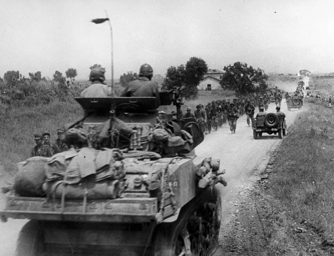
This original and rare museum-grade World War II Italian Theater Campaign 1943 dated combat map is a rare FIRST EDITION used by Allied Infantry and Armored Divisions during Allied operations in Italy. The Allied invasion of Italy was the Allied amphibious landing on mainland Italy that took place from 3 September 1943, during the Italian campaign of World War II. The operation was undertaken by General Sir Harold Alexander's 15th Army Group (comprising General Mark W. Clark's American Fifth Army and General Bernard Montgomery's British Eighth Army) and followed the successful Allied invasion of Sicily. The main invasion force landed on the west coast of Italy at Salerno on September 9 as part of Operation Avalanche, while two supporting operations took place in Calabria (Operation Baytown) and Taranto (Operation Slapstick).
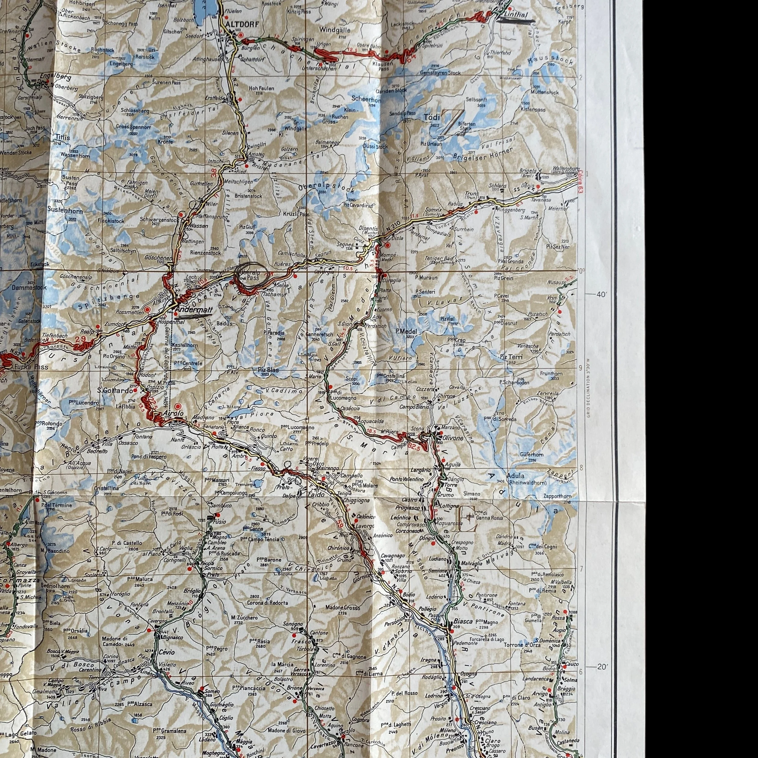
The campaign in Italy during World War II represented a critical theater of operations for the Allies in their quest to defeat Nazi Germany and its Axis partners. Beginning with the invasion of Sicily in July 1943, the Allies pushed northward through the Italian peninsula, facing formidable terrain and determined German resistance. Among the numerous battles and operations that characterized this campaign, the engagements around the cities of Linthal, Engelberg, Altdorf, Bellinzona, and Sion stand out as significant milestones in the Allied advance.
The invasion of Italy was a complex endeavor that involved meticulous planning, coordination, and execution by the Allied forces, primarily composed of American, British, Canadian, and other Commonwealth troops. The strategic objectives of the Allied advance into Italy included securing ports, disrupting Axis supply lines, and ultimately threatening the southern flank of Nazi Germany. The initial landings in Sicily, codenamed Operation Husky, provided the Allies with a foothold in the Mediterranean and set the stage for further offensives on the Italian mainland.
As the Allies moved northward from Sicily, they encountered rugged terrain, formidable defensive positions, and determined German resistance. The mountainous regions of Italy, particularly in the northern areas bordering Switzerland, posed significant challenges for advancing Allied forces. The cities of Linthal, Engelberg, Altdorf, Bellinzona, and Sion, situated in or near these mountainous regions, became focal points of intense combat as the Allies sought to break through German defenses.
One of the key elements that facilitated the Allied advance was the effective use of maps. In the mountainous terrain of Italy, where visibility could be limited and navigation challenging, maps played a crucial role in planning maneuvers, coordinating troop movements, and identifying strategic objectives. Infantry and armored units relied on detailed topographic maps to navigate through rugged terrain, identify key defensive positions, and plan their attacks.
For example, in the engagement around the city of Linthal, Allied forces would have utilized maps to plot routes through the mountain passes, identify potential ambush sites, and coordinate with supporting units. Similarly, in Engelberg and Altdorf, where German forces were entrenched in defensive positions overlooking narrow valleys and passes, Allied commanders would have relied on maps to plan flanking maneuvers and coordinate artillery support.
The city of Bellinzona, located near the Swiss border, represented a crucial gateway for the Allied advance into northern Italy. Here, Allied forces would have used maps to identify river crossings, bypass enemy strongpoints, and coordinate amphibious assaults if necessary. The strategic importance of Bellinzona, situated at the confluence of several key routes through the Alps, made it a focal point of intense fighting during the Allied advance.
Further north, the city of Sion served as another critical objective for the Allies. Situated in the Rhone Valley and surrounded by mountains, Sion presented significant challenges for advancing Allied forces. Infantry and armored units would have relied on maps to identify avenues of approach, coordinate with air support, and exploit weaknesses in the German defenses.
In addition to maps, Allied forces also utilized aerial reconnaissance and intelligence to gather information about enemy positions, terrain features, and defensive fortifications. By combining these sources of information with detailed maps, Allied commanders were able to formulate effective strategies and tactics to overcome the challenges posed by the mountainous terrain of Italy.
The Allied advance into Italy was a protracted and costly campaign, marked by fierce fighting, harsh weather conditions, and logistical challenges. However, through perseverance, determination, and effective use of resources such as maps, the Allies were able to gradually push German forces out of Italy and pave the way for the eventual liberation of Western Europe.
In conclusion, the U.S. and Allied advance into Italy during World War II represented a significant chapter in the overall Allied effort to defeat Nazi Germany. The battles around the cities of Linthal, Engelberg, Altdorf, Bellinzona, and Sion underscored the challenges posed by Italy's rugged terrain and the importance of effective planning and coordination. The use of maps was instrumental in guiding Allied forces through the mountainous regions of Italy, enabling them to overcome German defenses and advance toward victory.