VERY RARE! WWII 1944 "SECRET" 4th Marine Division D-Day Amphibious Attack Map Operation Burlesque-Camouflage Pacific Theater


VERY RARE! WWII 1944 "SECRET" 4th Marine Division D-Day Amphibious Attack Map Operation Burlesque-Camouflage Pacific Theater
Comes with a hand-signed C.O.A. and a full historical researched write-up
SHOWS D-DAY LANDING BEACHES OF GREEN 2 AND GREEN 1.
*The 4th Marine Division under Major General Harry Schmidt was to assault Roi-Namur, and the Army 7th Infantry Division under Major General Charles H. Corlett would attack Kwajalien. After these islands were taken, there was one more objective in the Marshalls: Eniwetok Atoll. This was targeted for attack some three months later by a task force comprised of the 22d Marine Regiment (called in the Corps the "22d Marines") and most of the Army's 106th Infantry Regiment. Brigadier General Thomas E. Watson, USMC, would be in command. As a preliminary to these priority operations, the occupation of another atoll in the eastern Marshalls was planned. This objective was Majuro, which would serve as an advanced air and naval base and safeguard supply lines to Kwajalein 220 miles to the northwest. Because it was believed to be very lightly defended, only the Marine V Amphibious Corps Reconnaissance Company and the 2d Battalion, 106th Infantry, 7th Infantry Division were assigned to capture Majuro. To support all of these thrusts there would be a massive assemblage of U.S. Navy ships: carriers, battleships, cruisers, destroyers, and an astonishingly varied array of transports and landing craft. These warships provided a maximum potential for intensive pre-invasion aerial bombing and ship-to-shore bombardment; the increased tonnage in high explosives, the lengthened duration of the softening-up process. and the pinpointing of priority enemy targets were all lessons sorely learned from the inadequate preparatory shelling which had contributed to the steep casualties of Tarawa. For the Marshalls, there were altogether 380 ships carrying 85,000 men.
In late 1943, the U.S. Combined Chiefs of Staff decided to plan an attack on the Marshall Islands as part of the ongoing island-hopping campaign in the Pacific. Recent victories at Makin and Tarawa in the Gilbert Islands facilitated the construction of airbases and ports to supply the next ‘jump’ en route to the Japanese home islands.
The Marshalls were part of Japan’s outer ring of defenses and were reinforced with nearly 30,000 troops in strong defensive positions. The Allied assault began in late January 1944, and focused on the Kwajalein Atoll in the heart of the island group. The largest landmasses were Kwajalein Island and the linked island of Roi-Namur, the latter shown on this map that was created a month before the attack began.
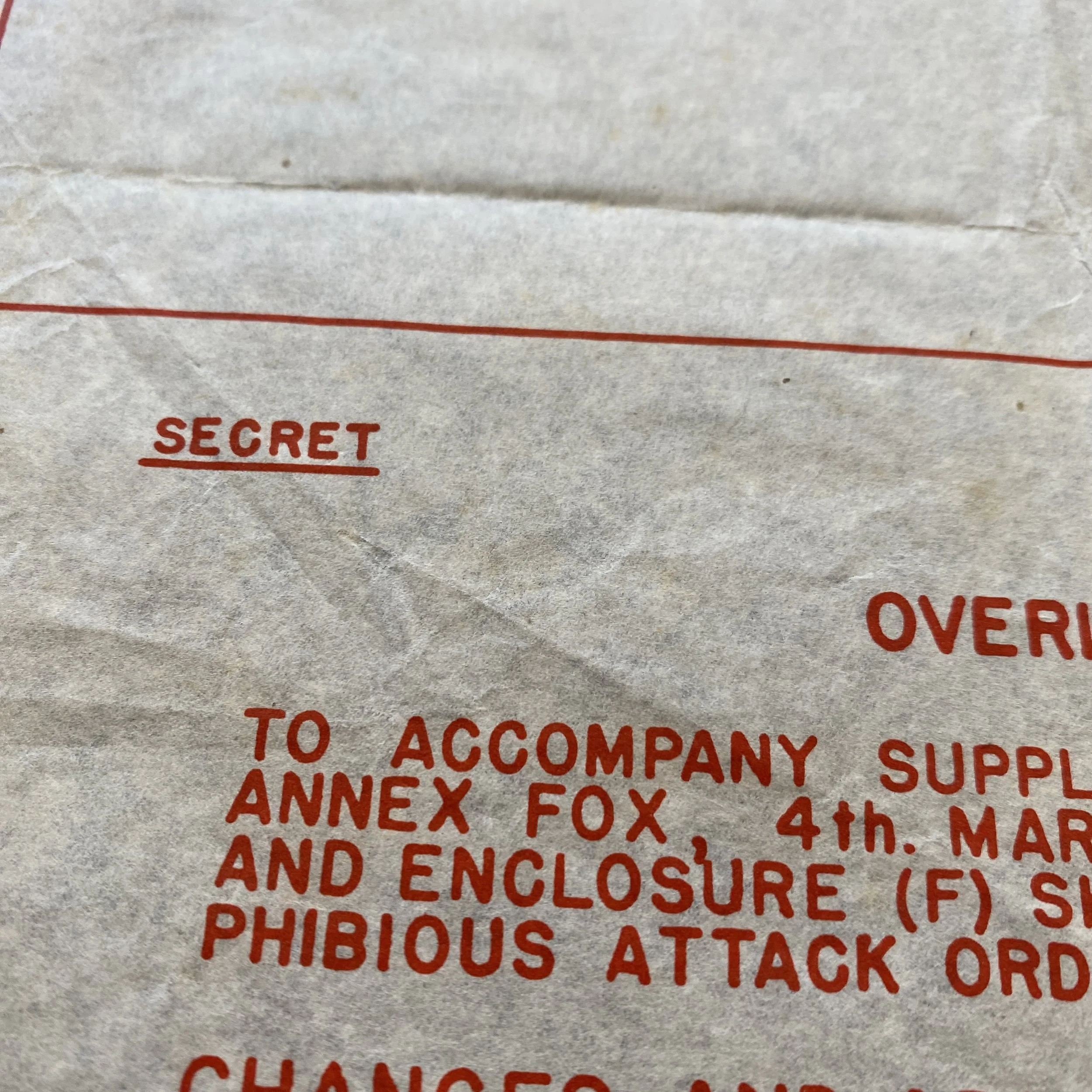
Marked SECRET this map overlay provides a detailed overview of Japanese defenses amid the inhospitable terrain. (Burlesque, Camouflage, and Carillon were the codenames used for Roi, Namur, and Kwajalein).
During World War II, the Pacific Theatre witnessed some of the most intense and strategic battles between Allied and Axis forces. Among these, the Burlesque and Camouflage Islands Carillon Atoll in the Marshall Islands played a significant role in the D-Day invasion of the Fifth Amphibious Force by the Fourth Marine Division. Despite being marked "SECRET," this assault map overlay holds invaluable historical significance, shedding light on the complex operations that took place during the Allied campaign in the Pacific.
I. The Carillon Atoll and its Strategic Importance:
Carillon Atoll, part of the Marshall Islands in the central Pacific, is composed of numerous islands, among which are the Burlesque and Camouflage Islands. The atoll's strategic location made it an important target for both the Allied and Axis powers during World War II. Its possession would enable better control of the surrounding regions and offer valuable forward bases for further military offensives.
II. Development of the Assault Map Overlay:
The production of the assault map overlay for the northern attack force of the Fourth Marine Division was a meticulously planned operation. This map was created to provide the Marines with crucial intelligence regarding the terrain, enemy defenses, and potential obstacles they might encounter during the D-Day invasion.
Military intelligence personnel, cartographers, and reconnaissance units worked tirelessly to gather data, survey the islands, and analyze aerial and satellite imagery. They combined this information to create a detailed and accurate map overlay that would guide the Marines through the invasion process.
III. The D-Day Invasion of the Fifth Amphibious Force:
The D-Day invasion of the Fifth Amphibious Force on the Burlesque and Camouflage Islands took place in 1944. The operation was part of a larger strategic campaign aimed at weakening the Japanese hold on the Pacific and securing vital positions for future offensives.
The assault began with a comprehensive naval bombardment, where Allied ships and aircraft bombarded enemy defenses, attempting to soften their resistance. The map overlay proved to be invaluable during this stage, enabling the Allied forces to target specific enemy positions with precision.
IV. Challenges and Tactics:
As with any military operation, the invasion of the Carillon Atoll was not without challenges. The Japanese forces, deeply entrenched on the islands, put up a fierce defense. The rugged terrain, dense vegetation, and well-fortified bunkers posed significant obstacles for the invading Marines.
To overcome these challenges, the Allied forces employed various tactics, including amphibious assaults, combined arms warfare, and coordinated air support. The assault map overlay played a crucial role in guiding the Marines through the treacherous landscape, ensuring they avoided potential ambushes and targeted enemy positions effectively.
V. The Aftermath and Legacy:
The D-Day invasion of the Burlesque and Camouflage Islands was a resounding success for the Allied forces. The Fourth Marine Division secured control of the atoll, dealing a significant blow to the Japanese defenses in the region.
The assault map overlay and the careful planning that went into its creation played a crucial role in this victory. By providing real-time information and insights, the overlay enhanced the Marines' situational awareness, contributing to the efficiency and success of the operation.
The successful capture of the Carillon Atoll had a profound impact on the overall Pacific Theatre campaign. It provided a strategic foothold for further advancements towards Japan, ultimately leading to the downfall of the Axis powers in the region.
The Burlesque and Camouflage Islands Carillon Atoll in the Marshall Islands holds a remarkable place in the history of World War II. The assault map overlay marked "SECRET" was an essential tool in the success of the D-Day invasion of the Fifth Amphibious Force by the Fourth Marine Division. Through meticulous planning, intelligence gathering, and precise execution, the Allied forces secured this strategic location, contributing significantly to their overall victory in the Pacific Theatre. The legacy of this historic event serves as a reminder of the valor and sacrifices made by those who fought in this critical chapter of human history.
Detialed History on the D-Day Invasion of Operation Burlesque-Camouflage:
'Burlesque-Camouflage' was the US seizure of the islands of Roi and Namur in the Kwajalein atoll of the Marshall islands group in the central Pacific Ocean (1/2 February 1944).
Kwajalein atoll lies near the geographical centre of the Marshall islands group in the central part of the Pacific Ocean, and in the central portion of the western Ralik chain. Namu atoll, its nearest neighbour, is some 40 miles (65 km) to the south-east, and Kwajalein is 337 miles (542 km) to the south-east of Eniwetok and 245 miles (395 km) to the north-east of Jaluit. Truk atoll in the Caroline islands group is 925 miles (1490 km) to the west, and Guam in the Mariana islands group is 1,320 miles (2125 km) to the west-north-west.
Kwajalein is the largest atoll in the world, and has a length of 66 miles (106 km) and width of 20 miles (32 km), and its lagoon has an area of 839 sq miles (2174 km²), which was sufficient to accommodate the whole of the US Pacific Fleet in World War II. The atoll comprises 97 islands and islets, of which 38 are of significant size, but there are only 6.33 sq miles (16.4 km²) of land, and the average height of the land above sea level is a mere 6 ft (1.8 m).
In overall configuration, the atoll is a misshaped triangle with numerous breaks in the reef providing access into the lagoon. The atoll forms is basically two arms, the south and the west with a small portion extending to the north, areas which are normally known as western, southern, and northern or north-eastern Kwajalein. While islands and islets are scattered on most of the reef’s length, there is a gap constituting the Tabik Channel, 15 miles (24 km) wide and with only its western part passable at low tide because of a submarine reef on the southern side of the western arm. The larger islands are concentrated in four areas: two of these were bypassed by the war, namely the western end of the western arm with Ebadon island and a number of islets, and the eastern portion of the western arm’s southern side, an area to the east of the Tabik Channel and where the southern arm turns to the south with Ennugenliggelap, Yebbenohr and Nell islands as the most notable.
On the end of the southern arm is the atoll’s largest island, Kwajalein, while on the northern lode are the twin islands of Roi and Namur. To the north of Kwajalein is the considerably smaller Ebeye island, which was also defended by the Japanese. These were the main objectives for 'Flintlock'. Both these areas possessed numbers of smaller islands, some of which were used by the US forces as artillery firing positions to support the assault on the main islands.
Even though these island objectives were in the same atoll and part of the same operation, they were fought as independent battles as the islands of Kwajalein ('Porcelain') and Roi-Namur ('Burlesque' and 'Camouflage') are 42 miles (67.5 km) apart.
The many islets in the area of Kwajalein and Roi-Namur were also codenamed and are often used as many of the local names are very similar and some have no known local names. In general, the codenames for islets in the area of Roi-Namur began with A and those in the area of Kwajalein with B and C, although there were exceptions.
The twin islands of Roi and Namur lie at the extreme northern corner of the northward-projecting barrier reef, and are thus the most northerly islands of the Kwajalein atoll. Roi had been stripped of vegetation to make room for the construction of an airfield, hence 'Burlesque', and Namur was heavily covered with palms and brush, hence 'Camouflage'. Both islands are irregularly shaped and separated by 500 yards (460 m), but were connected by a sandbar along the lagoon side and a concrete causeway mid-way between the lagoon and ocean sides. A brush-covered and triangular point of land projected from this sandbar to the north, Pauline Point toward its outer end being crossed by the causeway. Roi measures 1,170 by 1,250 yards (1070 by 1145 m), while Namur is 800 by 890 yards (730 by 815 m). Both islands had extensive road systems. An airfield with one 4,300-ft (1310-m) south-west/north-east runway crossed at right angles by one 2,700-ft (825-m) south-east/north-west runway with another 2,700-ft (825-m) runway linking the northern ends of the two others, taxiways and dispersal areas occupied most of Roi, on which there were few buildings other than hangars and workshops.
All airfield support facilities and barracks, as well as large numbers of other workshops, were grouped in Namur’s southern and western portions. The L-shaped Yokohama Pier, 450 ft (140 m) long, extended into the lagoon from the central part of Namur, and a considerably shorter pier was located on the lagoon side of Roi near its south-eastern corner.
Both islands are low and flat. On their ocean side the reef is 125 to 450 yards (115 to 410 m) wide and on its outer side drops steeply, resulting in heavy surf conditions. On the islands' lagoon sides the reef is more gradually sloped and brushed by light surf. There are three sandbars close to Namur’s south-eastern corner, and a line of small islands and islets extends to the south-east from Namur along the atoll’s barrier reef. The largest of these, and the closest, are Ennugarret (Abraham) 460 yards (420 m) distant, Ennumennent (Albert), Ennubirr (Allen) and Obella (Andrew). About 2 miles (3.2 km) to the south-west of Roi is the very small Ennuebing (Jacob) on the edge of the narrow Jacob Pass and 2 miles (3.2 km) farther still is the larger Mellu (Ivan) beside the main entrance into the lagoon, the Mellu Channel (Ivan pass).
The Japanese had located most of their defences on Roi’s northern and western shores and Namur’s northern and eastern shores as they expected any amphibious assault to be made from the ocean. Light defences were being built on the southern shores by the 61st Guard Force Despatched Force, 24th Air Flotilla Headquarters, under Rear Admiral Michiyuki Yamada, the service personnel of air units without aircraft, and a detachment of the 4th Fleet Construction Unit. Of the 3,000 men on the two islands, more than 2,000 were service personnel, but were nonetheless organised for ground combat.
Admiral Chester W. Nimitz, commander-in-chief of the Pacific Fleet and the Pacific Ocean Areas, decided, in the face of the advice of staff officers and some of his subordinate commanders, to bypass the outlying atolls of the Marshall islands group and strike first at the Japanese headquarters on Kwajalein. Events were to confirm that this was an excellent decision at the tactical, operational and strategic levels, for the Japanese defence plan was based on the premise that the US forces would perforce have first to take one of the outer atolls, and had therefore deployed the bulk of their troops in areas away from Kwajalein. The US forces had also learned much from their hard experiences in the 'Longsuit' assault on Tarawa atoll, and the preliminary bombardment would be considerably more effective and a larger proportion of the troops would be landed in amphibian tractors in assault waves whose scheduling was arranged with better attention to the tides. As a result, the US casualties were proportionally far lighter than those at Tarawa despite the fact that a larger garrison was attacked.
Preliminary raids against Kwajalein began as early as 4 December 1943, when Rear Admiral Charles A. Pownall led a force of six aircraft carriers, 10 cruisers and 11 destroyers to bombard the islands. Pownall’s force put 249 warplanes over the atoll, and these sank six transports and shot down 55 aircraft for a loss of just five of their own number. The incoming attacks were detected by the Japanese, however, and they were thus able to put about 50 fighters into the air, and the results were therefore less satisfactory than had been expected. Pownall withdrew at once, citing the exhaustion of his pilots and the lack of night-fighter support. During the withdrawal, the fleet carrier Lexington suffered a torpedo hit in her stern, and this left the carrier unsteerable for 20 minutes.
Long-range bomber attacks in January 1944 failed to complete the total suppression of the Japanese air power in the Marshall islands group, but from 29 January a series of powerful carrier strikes annihilated the remaining Japanese aircraft. These strikes continued through the period of the landing operations and ended on 6 February with the final attacks on Eniwetok. The strikes were carefully co-ordinated, with top cover by Grumman F6F Hellcat fighters to intercept any Japanese fighters while other Hellcat aircraft operated in the fighter-bomber role to bomb and strafe aircraft revetments, Douglas SBD Dauntless dive-bombers attacked anti-aircraft positions, and Grumman TBF Avenger level bombers dropped fragmentation clusters on revetments and 2,000-lb (907-kg) HE bombs to crater runways. The last Japanese aeroplane to be seen over Kwajalein was shot down on 29 January. The cost to the Americans was 49 aircraft and 48 aircrew in 4,021 sorties.
The US forces involved in 'Flintlock' were more than adequately covered by Vice Admiral Marc A. Mitscher’s Fast Carrier Task Force (Task Force 58) of Vice Admiral Raymond A. Spruance’s 5th Fleet, to which overall control of 'Flintlock' was entrusted. The 5th Fleet’s major assault element was Rear Admiral Richmond K. Turner’s 5th Amphibious Force (including Major General Holland M. Smith’s V Amphibious Corps) with TF58 sweeping ahead of it to eliminate Japanese air strength on the Marshall islands.
The US force was divided into a Southern Attack Force to tackle Kwajalein, and Rear Admiral Richard L. Conolly’s Northern Attack Force (Task Force 53) to make the assault on Roi and Namur. The US ships took up station to the west of Roi and Namur with the 4th Marine Division (14th [artillery], 20th [engineer], and 23rd, 24th and 25th Marines) aboard in the early hours of 31 January. Under the command of Major General Harry Schmidt, the division had departed San Diego, California in mid-January 1944 to be the first marine division committed directly to combat from the continental USA and thus undertaking the longest shore-to-shore amphibious assault (4,300 miles; 6920 km) up to that time.
The operation’s first phase called for elements of the 25th Marines to secure Jacob and Ivan, which controlled the Ivan Pass into the lagoon to the south-west of Roi. Elements landed on the islets at 09.55 had secured both by 10.15, allowing the ships of the naval task force to enter the lagoon. Other elements of the same regiment later landed on Allen, Albert and Andrew to the south-east of Namur between 15.10 and 15.45, and had secured all of these within an hour, there following at 18.30 a landing on Abraham, which had been secured within 45 minutes. Supporting regimental and battalion weapons were emplaced on Abraham, the islet nearest to Namur, and single artillery battalions were then emplaced on Jacob, Ivan, Albert and Allen. It is estimated that 35 Japanese were killed and five taken prisoner on these islets, while the marines lost 18 men killed, eight missing and 40 wounded.
The operation’s second phase was scheduled to start at 10.00 on on 1 February, when the 23rd and 24th Marines were to have assaulted Roi and Namur respectively, but difficulties with the assembly of the amphibian tractors delayed the assault for two hours. With two battalions abreast in amphibian tractors, the 23rd Marines landed on Beaches Red 2 and Red 3 on Roi’s southern shore at 11.57, and the marines then swept across the airfield, which was declared secure at 18.02.
At 11.55 the 24th Marines landed on the southern shore of Namur over Beaches Green 1 to the west of Yokohama Pier and Green 2 (to the east of this pier. The regiment also secured the causeway and sandbar connecting the two islands. At 13.05 a great detonation shook Namur, a large mushroom cloud covered most of the island, and shattered palm trees and huge chunks of concrete were hurled hundreds of yards: marines attacking a large concrete bunker in the island’s south-east had hurled satchel charges into this, causing the detonation of large numbers of torpedoes and two adjacent ammunition magazines. Some 20 marines were killed and about 100 injured, which constituted more than half of the casualties suffered by the 2/24th Marines on Namur. Regardless of this event, by the fall of night the 24th Marines had driven their way about three-quarters of the way across Namur. The attackers reached Natalie Point on the island’s northern end at 12.15 hours on the following day, and the island was declared secure at 14.18.
The marines counted 3,472 Japanese dead on both islands, but hundreds more were buried in bunkers. Some 91 prisoners were taken. The marines had lost 206 killed, 181 missing and 531 wounded.
By 6 February the 25th Marines had searched another 47 of the atoll’s other islands and islets and found nothing. The only Japanese air attack which got through to the atoll, carrier strikes having neutralised all the Japanese airfields in the Marshall islands group, was on 12 February and struck Roi, destroying much of the marines' ammunition stockpiles, killing 30 men and wounding 400.