RARE! WWII 1945 U.S. Navy LORAN Air Navigation Map GUAM - KWAJALEIN - SAIPAN - NEW GUINEA


RARE! WWII 1945 U.S. Navy LORAN Air Navigation Map GUAM - KWAJALEIN - SAIPAN - NEW GUINEA
Comes with hand-signed C.O.A.
*SHOWS NAVIGATIONAL AND COMBAT MARKINGS DIRECTLY ON AND AROUND THE ISLANDS O GUAM (MARIANAS ISLANDS) AND KWAJALEIN (MARSHALL ISLANDS).
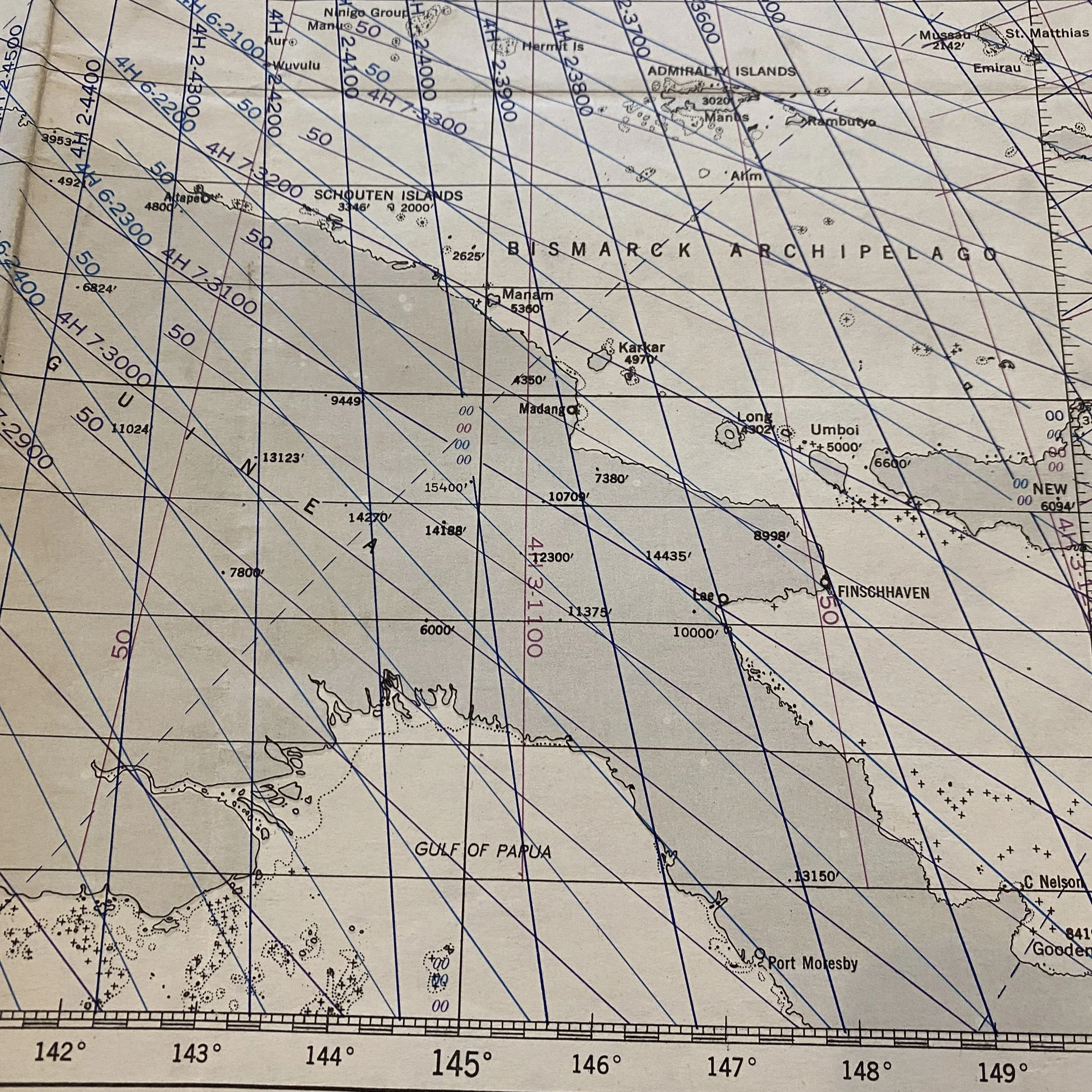
This incredibly rare and museum-grade World War II U.S. Navy LORAN Air Navigation map is a very rare and scarcely printed navigational chart used in the Pacific Theater. This very rare SECOND EDITION Pacific Theater plotting chart is dated March 1945 and is extremely detailed with the SECRET LORAN system used for navigating to missions and designated targets throughout the Pacific Theater.
This map was originally marked “CONFIDENTIAL” before being overstamped “RESTRICTED”. This was done for combat maps that had very special and classified information. RESTRICTED markings on WWII maps were done when the map was used in combat. This map shows the islands of GUAM, WAKE ISLAND, NEW GUINEA, TRUK, GILBERT ISLANDS, PALAU ISLAND, MARSHALL ISLANDS, KWAJALEIN, SAIPAN, MARIANAS ISLANDS,
LORAN (LOng RAnge Navigation) System:
During World War II, navigation was a critical aspect of aerial warfare. The ability to accurately determine one's position and navigate to a target or return home safely was crucial to the success of missions. One of the most important navigation aids during this period was the LORAN (LOng RAnge Navigation) system.
The LORAN system was first developed in the 1930s by a team of engineers led by Alfred Loomis, who was working for the Radio Corporation of America (RCA). LORAN was designed to provide accurate navigation for ships at sea, but its utility was quickly recognized for use by aircraft as well.
The system worked by sending out a radio signal from two or more transmitters located at known positions on the ground. These signals would be received by an aircraft equipped with a LORAN receiver, which would measure the difference in time between the arrival of the signals. By comparing the time differences, the aircraft could determine its position relative to the known locations of the transmitters.
LORAN was superior to other navigation aids available at the time, such as radio direction finding (RDF) and celestial navigation. RDF required the use of a directional antenna and relied on the reception of signals from a single transmitter, making it vulnerable to jamming and interference. Celestial navigation, while accurate, was limited by the need for clear weather and a clear view of the stars.
LORAN, on the other hand, could provide accurate navigation regardless of weather conditions or interference. The system was also difficult to jam, as the signals were transmitted on a low frequency and were spread out over a wide band. This made LORAN a valuable asset for both Allied and Axis forces during World War II.
The use of LORAN was especially important for missions over the Atlantic Ocean, where long distances and poor weather conditions made navigation difficult. The system was also used extensively in the Pacific Theater, where the vast distances and numerous small islands made navigation a challenge.
LORAN played a significant role in several important missions during the war. One notable example was the Doolittle Raid on Tokyo in April 1942. The raid, which involved the launch of B-25 bombers from the aircraft carrier USS Hornet, required accurate navigation to reach their targets in Japan and then return to friendly territory in China. LORAN was instrumental in providing this navigation, allowing the bombers to hit their targets and return safely.
Another example of the importance of LORAN was during the Battle of the Atlantic, where the Allies used the system to track German U-boats. LORAN receivers were installed on aircraft and ships, allowing them to accurately locate and attack U-boats even in poor weather conditions. This helped to turn the tide of the battle in the Allies' favor.
After the war, LORAN continued to be used for navigation, both by civilian and military aircraft. The system was continually improved, with the development of more accurate transmitters and receivers, and the addition of new features such as Doppler navigation.
In conclusion, the LORAN navigation system played a crucial role in aerial navigation during World War II. Its accuracy and reliability allowed aircraft to navigate accurately over long distances and in poor weather conditions, contributing to the success of numerous missions. The system's continued use after the war demonstrates its value and importance in the history of navigation.
This chart shows great theater use for its age and would make an amazing addition to any WWII collection.