VERY RARE! Heavily Mission Marked 1945 Iwo Jima Okinawa & Japan USAAF Heavy Bomber Air Raid Mission Navigation Map


VERY RARE! Heavily Mission Marked 1945 Iwo Jima Okinawa & Japan USAAF Heavy Bomber Air Raid Mission Navigation Map
Comes with a hand-signed C.O.A. and a full historical research document/write-up
*HEAVY COMBAT AIR MISSION MARKINGS AROUND OKINAWA. SHOWS ALL MAJOR JAPANESE TARGET DESIGNATIONS SUCH AS IWO JIMA, HIROSHIMA, NAGASAKI, ETC.
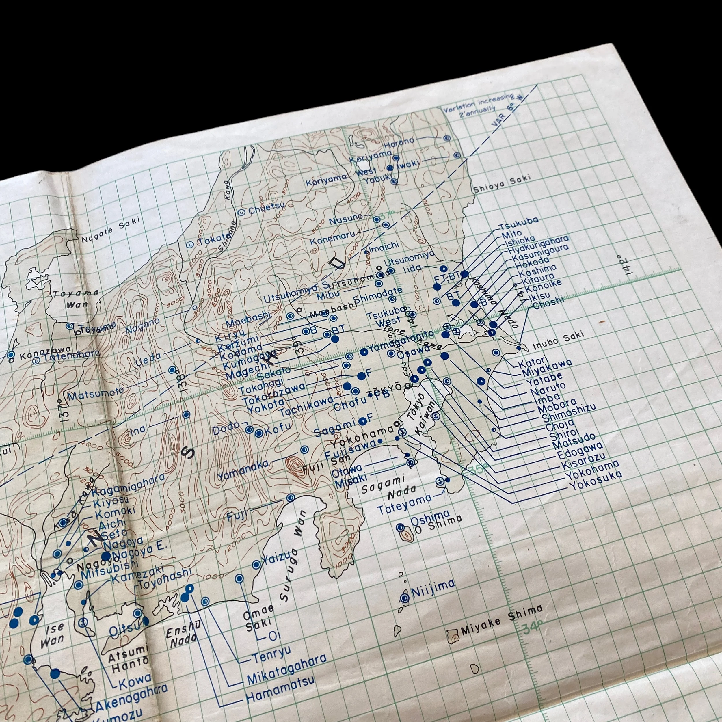
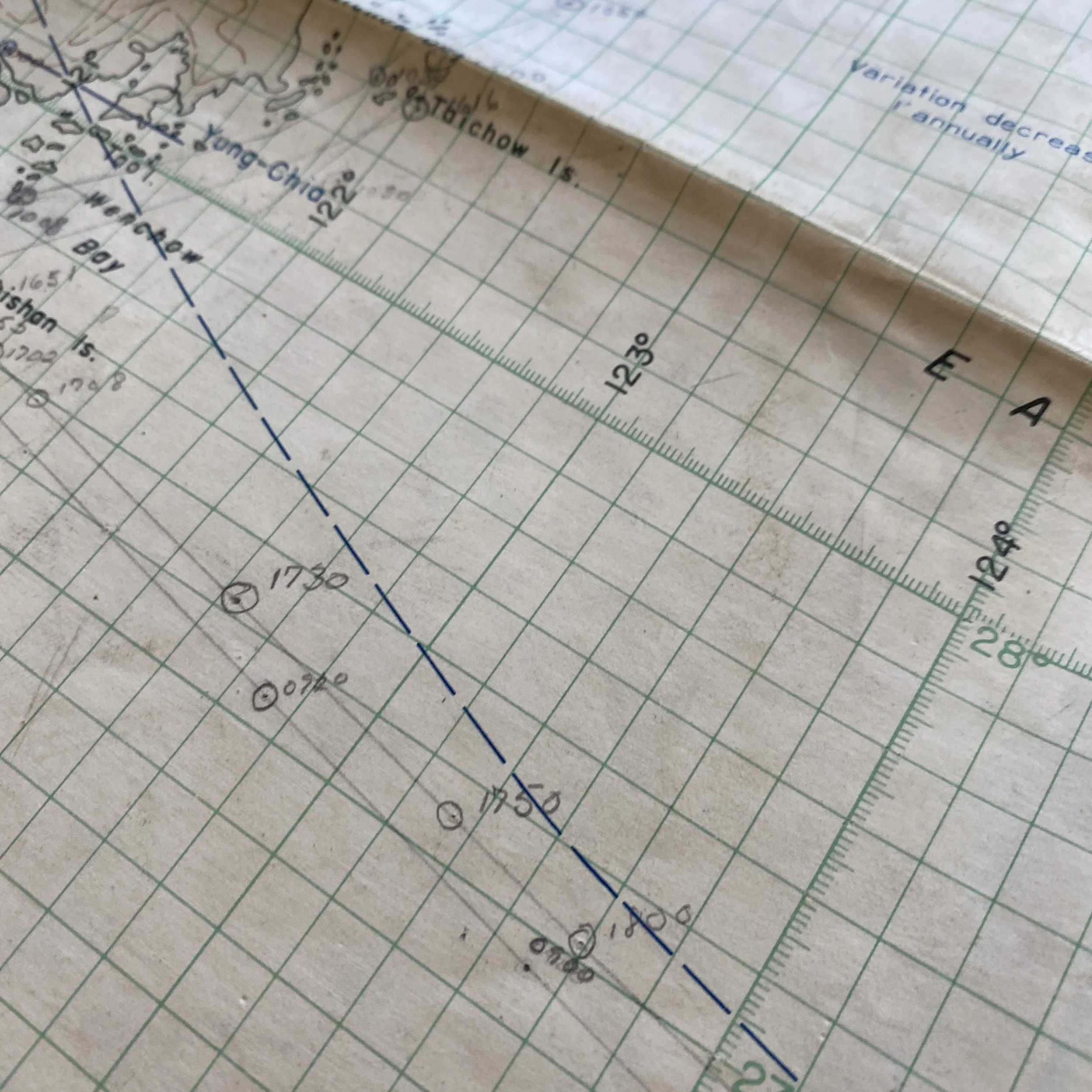
The Air Navigation Chart, marked "RESTRICTED," played a pivotal role during World War II in guiding aviators through the perilous skies of the Pacific Theater. Dated May 1945, this RESTRICTED air map aided allied forces in their missions across the vast expanse of the Pacific Ocean, most notably during the battles of Iwo Jima and the strategic bombing campaigns on mainland Japan.
The Pacific Theater in May 1945:
By May 1945, World War II had been raging for nearly six years, and the Pacific Theater had become a critical battleground for the Allied and Axis forces. The Battle of Iwo Jima, which concluded in March 1945, had been a costly and challenging operation, with the United States Marine Corps fighting ferociously to capture the small volcanic island. The successful capture of Iwo Jima provided a crucial forward base for allied aircraft and enabled the launch of devastating bombing raids on mainland Japan.
Meanwhile, on the main islands of Japan, the Japanese military and civilians were facing relentless aerial bombardments by the United States Army Air Forces (USAAF) and the United States Navy. These strategic bombing campaigns aimed to cripple Japan's industrial capacity and diminish their ability to wage war effectively.
The Importance of Air Navigation Charts
In the vast expanse of the Pacific Theater, accurate air navigation was crucial for successful missions. Pilots and navigators relied heavily on air navigation charts to plan their routes, estimate fuel consumption, calculate wind corrections, and identify potential hazards. The "Air Navigation Chart" provided vital information on aeronautical navigation, including radio beacons, waypoints, magnetic variations, and airfields, among other critical data.
The restricted nature of the map underscored its importance in safeguarding strategic information. Access to such data was limited to authorized personnel to prevent enemy intelligence gathering. This heightened secrecy ensured that valuable intelligence on flight paths and targets remained out of enemy hands.
Missions on Iwo Jima:
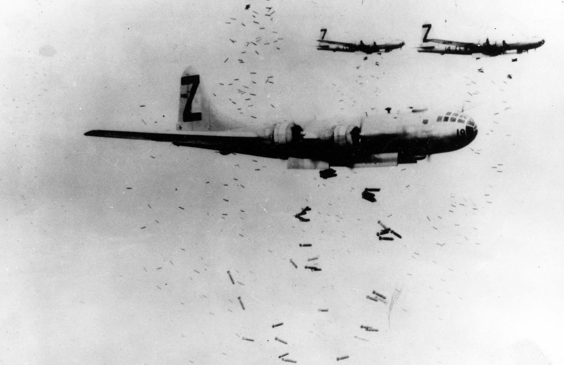
The Battle of Iwo Jima was a turning point in the Pacific Theater. After the island's capture, the airfield was transformed into a crucial base for long-range B-29 Superfortress bombers, which played a decisive role in the strategic bombing of mainland Japan. The "Air Navigation Chart" was indispensable for planning these bombing missions. B-29 crews meticulously studied the map to chart their courses and identify specific targets.
Strategic Bombing Campaigns on Mainland Japan:
The strategic bombing campaigns over mainland Japan were relentless and aimed at crippling the Japanese war effort. The air navigation chart played a central role in planning these missions, particularly during the night incendiary raids and daylight precision bombing runs.
For the night incendiary raids, which aimed to create massive firestorms in urban areas, the crews had to follow specific routes to maximize the impact of the bombing. The chart provided crucial information on landmarks, radio beacons, and waypoints, which guided the bombers through the darkness to their targets.
During daylight precision bombing runs, such as the infamous raid on Tokyo on March 9, 1945, the air navigation chart helped aviators to accurately navigate to their designated targets, often industrial facilities and military installations. These missions were highly risky, as they required flying at low altitudes to improve bombing accuracy while exposing the aircraft to heavy anti-aircraft fire.
Air Navigation and Target Maps: The Key to Success:
The success of the Allied efforts in the Pacific Theater can be attributed in large part to the effective utilization of air navigation and target maps like the "Air Navigation Chart." These maps were instrumental in planning and executing missions that were critical to achieving strategic objectives.
Island-Hopping Strategy: The island-hopping strategy employed by the Allies involved capturing key islands in the Pacific to establish airfields and naval bases, gradually moving closer to the Japanese mainland. Air navigation charts were crucial in guiding aircraft between these islands, ensuring a safe and efficient route for troop transport and resupply missions.
Long-Range Bombing: The capture of Iwo Jima provided the Allies with a critical forward base for B-29 Superfortress bombers, which had the range to reach mainland Japan. Air navigation charts were used to plan these long-range bombing missions, considering factors like prevailing winds, fuel consumption, and target coordinates. The raids were instrumental in weakening Japanese defenses and demoralizing the enemy.
Precision Bombing: Daylight precision bombing required meticulous planning, as bombers had to fly at low altitudes to hit their targets accurately. Air navigation charts played a vital role in guiding the aircraft along specific flight paths, avoiding enemy defenses, and ensuring precise targeting.
Night Incendiary Raids: To maximize the impact of the night incendiary raids, which aimed to create firestorms in urban areas, air navigation charts helped bombers navigate through the darkness. The charts allowed pilots to identify landmarks and radio beacons to guide them to their intended targets.
Challenges and Risks Faced by Aviators:
Operating in the Pacific Theater presented immense challenges and risks for aviators. The vastness of the ocean, extreme weather conditions, and the relentless resistance from the Japanese forces posed significant threats.
Weather and Navigation: The vast stretches of the Pacific Ocean presented a navigational challenge for aviators. Strong crosswinds, unpredictable weather patterns, and long flight durations demanded precise navigation using air navigation charts to stay on course and reach their destinations safely.
Long Distance: The Pacific Theater covered a vast area, and many missions required long-range flights. These extended journeys meant that aircraft often flew close to their maximum range, leaving little margin for error in fuel consumption calculations.
Enemy Defenses: Japanese anti-aircraft fire and fighter aircraft posed a constant threat to the Allied forces. Aviators had to rely on evasive maneuvers and accurate navigation to avoid enemy defenses and complete their missions successfully.
Fatigue: Pilots and crew members faced fatigue during extended missions, such as the round-trip flights between the captured islands and the Japanese mainland. Maintaining focus and concentration was crucial to ensure the safe execution of their duties.
Legacy and Impact:
The use of air navigation charts during World War II revolutionized aviation practices and contributed significantly to the outcome of the Pacific Theater. The precision and accuracy of bombing runs improved, minimizing collateral damage and maximizing the impact on enemy targets. Additionally, the experience gained during the war laid the foundation for the development of modern navigation and targeting systems.
Beyond their military significance, air navigation charts also had a lasting impact on civilian aviation. The lessons learned during World War II greatly influenced the advancement of aeronautical navigation technology, making air travel safer and more efficient for generations to come.
The "Air Navigation Chart" marked "RESTRICTED," dating back to May 1945, holds a prominent place in the annals of history. During the final months of World War II in the Pacific Theater, this invaluable document guided aviators through treacherous skies, enabling them to undertake critical missions during the Battle of Iwo Jima and the strategic bombing campaigns on mainland Japan. By providing essential information on air navigation and targets, the chart played a pivotal role in achieving Allied victory in the Pacific.
The sacrifices and courage of the aviators who relied on this chart, facing immense challenges and risks, must not be forgotten. Their determination, along with the strategic use of air navigation and target maps, left a profound legacy on aviation practices and technology, shaping the future of both military and civilian flight navigation. The "Air Navigation Chart" remains a symbol of the ingenuity and perseverance of those who navigated the skies to secure a safer world for generations to come.